SUMMARY
This is AI generated summarization, which may have errors. For context, always refer to the full article.
What’s the weather like in your area? Report the situation through Rappler’s Agos or tweet us at @rapplerdotcom.
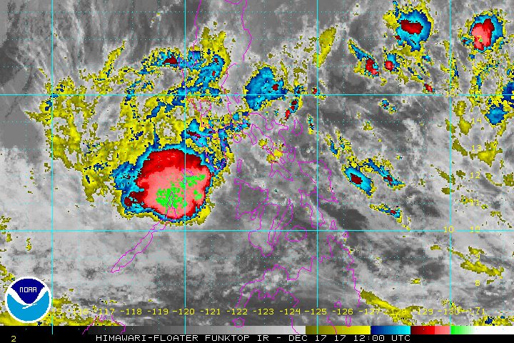
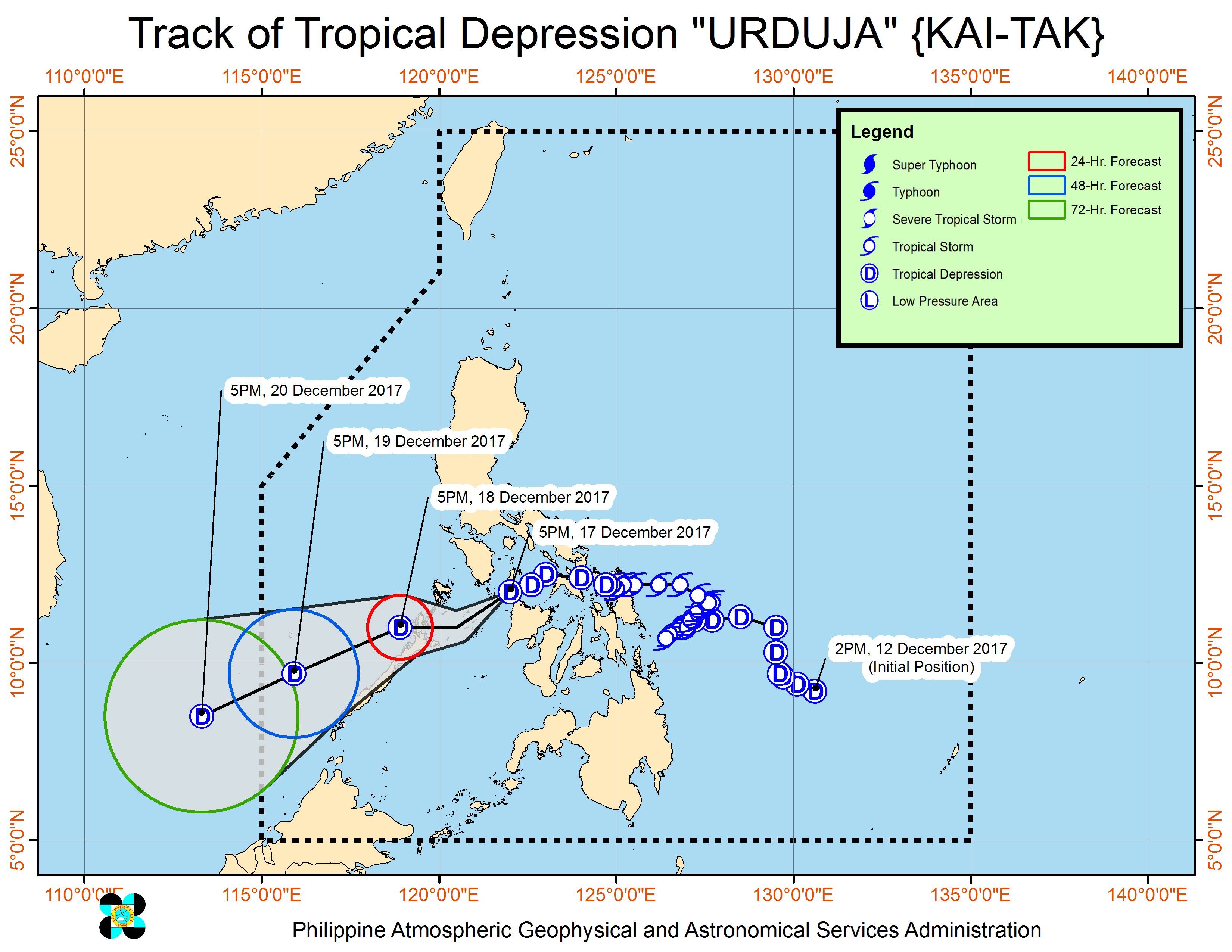
MANILA, Philippines – Tropical Depression Urduja (Kai-tak) made its 4th landfall in Malay, Aklan early Sunday evening, December 17.
In a bulletin issued 8 pm on Sunday, state weather bureau PAGASA said Urduja is already in the vicinity of Buruanga, Aklan, moving west southwest at 15 kilometers per hour (km/h).
The tropical depression continues to have maximum winds of 55 km/h and gustiness of up to 80 km/h. (READ: EXPLAINER: How tropical cyclones form)
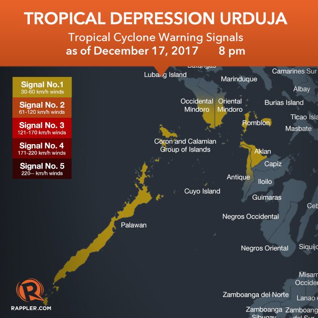
There are fewer areas under signal number 1:
- southern Occidental Mindoro
- southern Oriental Mindoro
- Romblon
- Palawan
- Aklan
- northern Antique
Before hitting Aklan, Urduja also made landfall in the following areas:
- San Policarpo, Eastern Samar – 1:30 pm, Saturday, December 16
- Mobo, Masbate – 10 am, Sunday, December 17
- Sibuyan Island – 12 noon, Sunday, December 17
PAGASA forecaster Aldczar Aurelio earlier said in a news briefing that a 5th landfall may occur in Palawan.
Urduja, which was earlier a tropical storm before weakening into a tropical depression, left at least 3 people dead and 19 others injured, based on data from the National Disaster Risk Reduction and Management Council (NDRRMC). But in the province of Biliran alone, the local government said landslides left at least 26 people dead.
Urduja dumped heavy rain that triggered floods and landslides, with its effects first felt in Eastern Visayas. (LOOK: Houses in Eastern Samar flooded due to Urduja)
PAGASA said residents of provinces in the tropical depression’s path “must undertake appropriate measures against flooding and landslides and coordinate with their respective local government and disaster risk reduction and management offices.” (READ: FAST FACTS: Tropical cyclones, rainfall advisories)
Below are the top 5 areas which received the most rainfall in terms of millimeters (mm) on Friday, December 15.
- Catarman, Northern Samar – 347.4 mm (normal monthly rainfall: 628.2 mm)
- Catbalogan, Samar – 331.2 mm (normal monthly rainfall: 322.7 mm)
- Juban, Sorsogon – 162 mm (no amount given for normal monthly rainfall)
- Borongan, Eastern Samar – 155 mm (normal monthly rainfall: 674.8 mm)
- Guiuan, Eastern Samar – 109.6 mm (normal monthly rainfall: 440.1 mm)
In a 24-hour period that began last Thursday, December 14, Guiuan had received nearly two months’ worth of rainfall in just one day, making it the hardest-hit overall, so far.
Meanwhile, sea travel remains risky in seaboards of areas under signal number 1. More than 16,000 passengers have been stranded at various ports. (LOOK: Passengers stranded in Tacloban transport terminal)
In a statement on Sunday, Presidential Spokesperson Harry Roque gave an assurance that “vital services, such as preparedness and response to disasters or calamities shall continue with their operations even during holidays.”
Roque said the Department of Social Welfare and Development (DSWD) has a stockpile of 368,000 family food packs worth P223 million, food and non-food items worth P393 million, and available standby funds amounting to P245 million.
The DSWD earlier said around 221,386 persons or 50,653 families across 4 regions are affected. (READ: #ReliefPH: Help victims of Urduja)
Based on its latest forecast track, Urduja will leave the Philippine Area of Responsibility (PAR) on Wednesday, December 20.
Vinta after Urduja
Aside from Urduja, PAGASA is also monitoring a tropical depression located 1,925 kilometers east of Mindanao, still outside PAR. It has maximum winds of 40 km/h and gustiness of up to 50 km/h.
The tropical depression will be given the local name Vinta once it enters PAR on Friday, December 22.
Asked how strong Vinta would be, Aurelio said: “Wala pa tayong data para doon pero inaasahan nating lalakas ito….Kitang-kita ‘nyo malayo pa lang itong bagyo, kitang-kita ninyo dagat ito at dito siya dadaan bago tumama sa lupa so makakaipon siya ng lakas….Kung aabot ng typhoon ‘di natin masabi sa ngayon, pero ang importante po paghandaan po natin ‘yung panibagong bagyo na nasa labas ng Philippine Area of Responsibility.”
(We still don’t have data for that but we expect it to strengthen….As you can see, this tropical cyclone is still far from the country, it’s still over water and it will pass through water before hitting land so it can still gain strength….Whether it will reach typhoon category we can’t say yet, but what’s important is that we should prepare for this new tropical cyclone that is outside the Philippine Area of Responsibility.)
Vinta will likely affect the Visayas and Mindanao, having a track similar to Urduja, added Aurelio. – Rappler.com
Add a comment
How does this make you feel?
There are no comments yet. Add your comment to start the conversation.