SUMMARY
This is AI generated summarization, which may have errors. For context, always refer to the full article.
What’s the weather like in your area? Report the situation through Rappler’s Agos or tweet us at @rapplerdotcom.
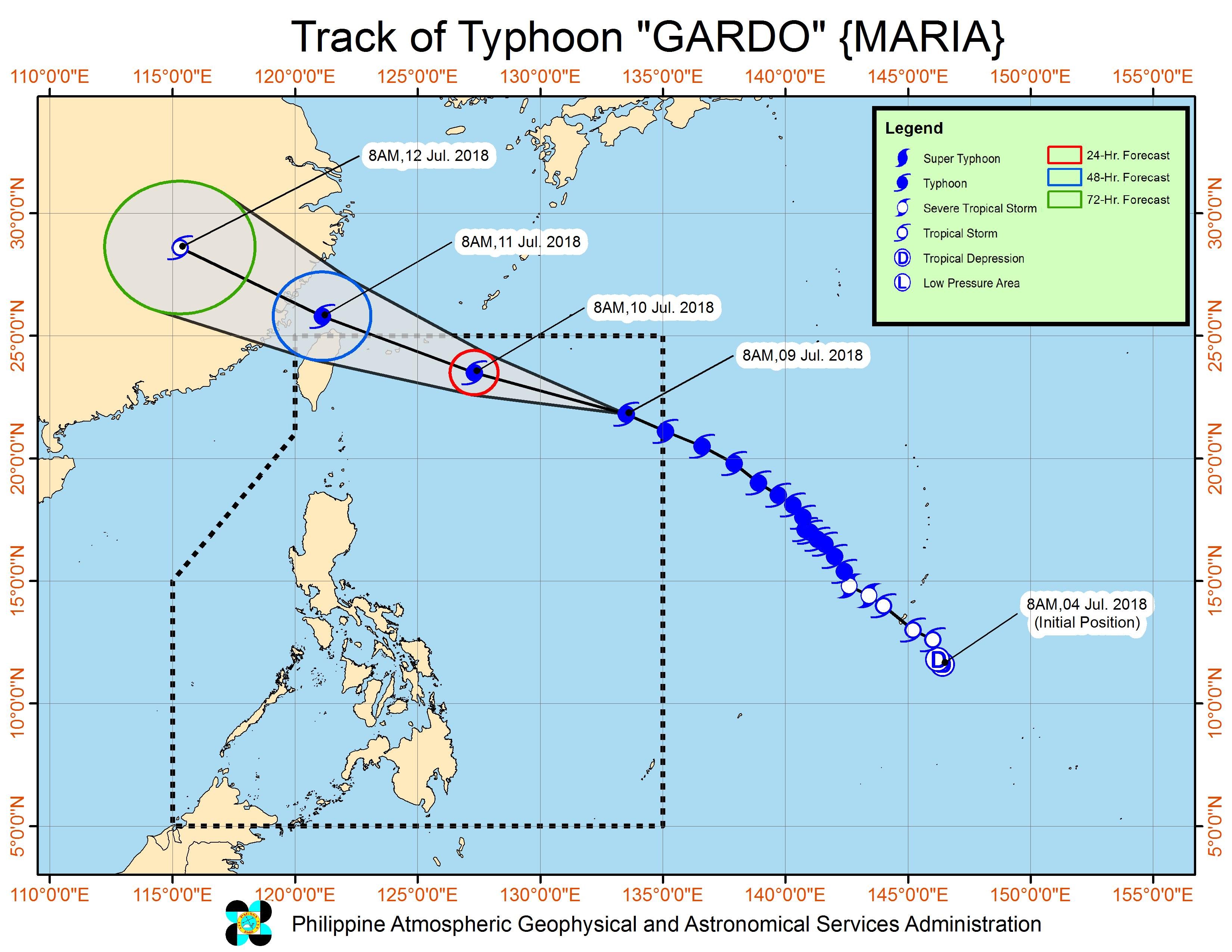
MANILA, Philippines – Typhoon Gardo (Maria) maintained its strength on Monday morning, July 9, after entering the Philippine Area of Responsibility (PAR) before dawn.
Gardo is not expected to make landfall in the Philippines, so tropical cyclone warning signals will not be raised in any area.
But PAGASA warned that the typhoon will enhance the southwest monsoon or hanging habagat.
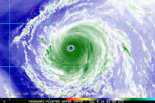
In a bulletin issued 11 am on Monday, state weather bureau PAGASA said Gardo is already 1,165 kilometers east of Basco, Batanes, still moving west northwest over the Philippine Sea at 30 kilometers per hour (km/h).
The typhoon continues to have maximum winds of 200 km/h near the center and gustiness of up to 245 km/h.
In a press briefing, PAGASA Weather Division chief Esperanza Cayanan explained why Metro Manila and other areas were generally sunny on Monday morning, when residents were already expecting heavy rain.
According to Cayanan, there is a low pressure area (LPA) in the West Philippine Sea affecting Gardo’s enhancement of the southwest monsoon, which is why the hanging habagat isn’t as strong yet.
“Dahil po may low pressure [area] dito, ‘yun po niyang hangin umiikot po dito, kaya nahihila, kaya medyo naii-spare tayo sa western section ng Luzon…. ‘Yan po ‘yung dahilan kung bakit hindi tayo nasasapul ng husto nung ulan ng habagat…. Pero pagtaas po nitong bagyo, kung tatawid na siya dito sa taas, at mawawala na itong low pressure system, posible pong mas lumakas na ‘yung habagat natin,” Cayanan said late Monday morning.
(Because there’s a low pressure area here, its air is circulating here, that’s why we’re mostly spared in the western section of Luzon…. That’s the reason why the rain from the southwest monsoon isn’t directly hitting us yet…. But when the typhoon moves further upward or starts crossing in the northern part, and the effect of the low pressure system will be diminished, the southwest monsoon could be enhanced.)
“Kanina nakita ‘nyo ‘yung haring araw [dahil] nasa offshore [or over the sea] lang po ang ulan…. Mamayang hapon po makakaranas na rin tayo ng mga thunderstorms, ng mga pag-ulan,” she added.
(It was sunny because the rain was still offshore [or over the sea]…. Later this afternoon we’ll be experiencing thunderstorms, rain.)
PAGASA warned that there will be monsoon rain in Mimaropa and Western Visayas beginning Monday until Wednesday, July 11.
Occasional rain will also hit Metro Manila, Calabarzon, Bicol, Zambales, Bataan, and Aurora from Monday until Tuesday, July 10.
“Medyo na-delay lamang. So huwag sana tayong mainip na magkaroon ng ulan. Pero expected na… itong remaining days of the week, ‘yun na ‘yung maulan na bahagi,” said PAGASA Weather Division assistant weather services chief Robert Sawi.
(The rain is just a bit delayed. Let’s not be impatient for the rain to arrive. We expect that… the remaining days of the week, it will be rainy.)
Residents of regions and provinces to be affected by the southwest monsoon, especially those in low-lying and in mountainous areas, should be on alert for possible flash floods and landslides. (READ: FAST FACTS: Tropical cyclones, rainfall advisories)
Due to the expected heavy rain on Monday, some areas in Luzon and Western Visayas suspended classes. (READ: #WalangPasok: Class suspensions, Monday, July 9)
PAGASA also warned that sea travel is risky in the northern and eastern seaboards of Northern Luzon.
The Philippine Coast Guard (PCG) earlier alerted its units in Bicol, Metro Manila, Central Luzon, Palawan, and Southern Tagalog to be on standby for any possible emergencies.
Based on its latest forecast track, Gardo will leave PAR on Wednesday morning, exiting just off Taiwan. Taiwan is still within PAR, an area set by the World Meteorological Organization (WMO) for PAGASA to monitor, as weather disturbances here directly or indirectly affect the Philippines. (READ: PAGASA: Typhoon Gardo different from Yolanda)
Gardo is the Philippines’ 7th tropical cyclone for 2018. The country usually gets an average of 20 tropical cyclones per year. (READ: LIST: PAGASA’s names for tropical cyclones in 2018)
PAGASA had declared the start of the rainy season last June 8. – Rappler.com
Add a comment
How does this make you feel?
There are no comments yet. Add your comment to start the conversation.