SUMMARY
This is AI generated summarization, which may have errors. For context, always refer to the full article.
What’s the weather like in your area? Report the situation through Rappler’s Agos or tweet us at @rapplerdotcom.
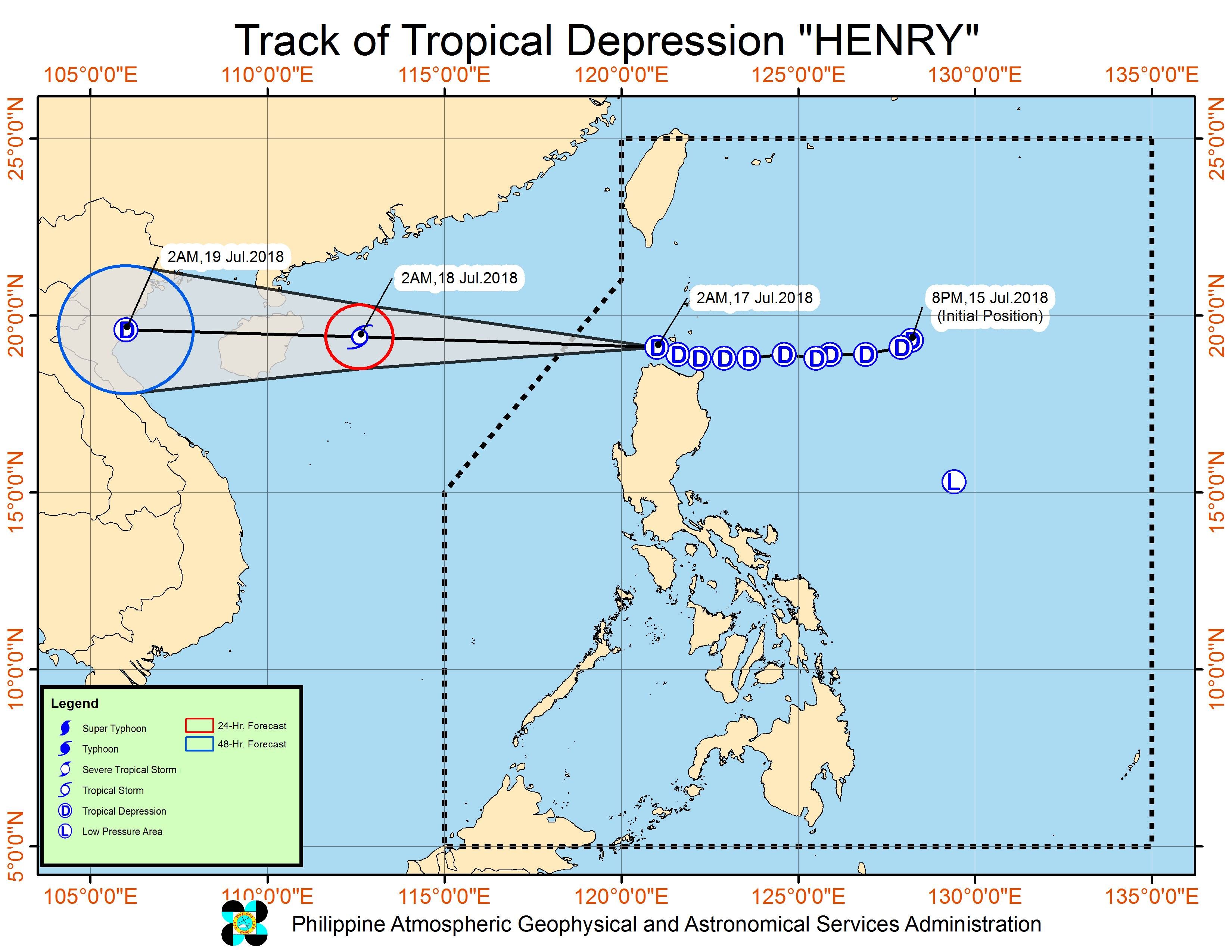
MANILA, Philippines – Tropical Depression Henry is now heading for the West Philippine Sea after making its 3rd landfall before dawn on Tuesday, July 17.
The tropical depression made landfall in the following areas in the province of Cagayan:
- Camiguin Island
- Fuga Island
- Dalupiri Island
In a bulletin issued 5 am on Tuesday, state weather bureau PAGASA said Henry is already 95 kilometers west of Calayan, Cagayan, moving west northwest at a slightly slower 20 kilometers per hour (km/h) from the previous 25 km/h.
The tropical depression continues to have maximum winds of 60 km/h and gustiness of up to 75 km/h.
Signal number 1 remains raised over:
- Batanes
- northern part of Cagayan including the Babuyan Group of Islands
- northern part of Apayao
- northern part of Ilocos Norte
PAGASA warned that occasional rains with gusty winds are expected in areas under signal number 1.
The tropical depression also continues to enhance the southwest monsoon or hanging habagat, which is bringing rain to Metro Manila, Zambales, Bataan, Cavite, Batangas, Oriental Mindoro, Occidental Mindoro, Palawan, and Western Visayas.
Scattered rainshowers and thunderstorms will also hit the rest of the country due to the southwest monsoon.
Areas affected by Henry and the southwest monsoon should stay on alert for possible flash floods and landslides. (READ: FAST FACTS: Tropical cyclones, rainfall advisories)
Several areas in Luzon have suspended classes for Tuesday due to heavy rain. (READ: #WalangPasok: Class suspensions, Tuesday, July 17)
PAGASA also warned that sea travel is risky in the western seaboard of Southern Luzon. Fishermen and others with small sea vessels are also advised not to venture out into the seaboards of areas under signal number 1 and the seaboards of the rest of Luzon. Both Henry and the southwest monsoon are causing moderate to rough seas.
Based on its latest forecast track, Henry is expected to leave the Philippine Area of Responsibility (PAR) on Tuesday morning.
Henry is the Philippines’ 8th tropical cyclone for 2018. The country usually gets an average of 20 tropical cyclones per year. (READ: LIST: PAGASA’s names for tropical cyclones in 2018)
Aside from Henry, PAGASA is also monitoring a low pressure area (LPA) located 825 kilometers east of Infanta, Quezon. This LPA is still too far to affect the country at the moment, but it could develop into a tropical depression within the next 48 hours.
PAGASA declared the start of the rainy season last June 8. – Rappler.com
Add a comment
How does this make you feel?
There are no comments yet. Add your comment to start the conversation.