SUMMARY
This is AI generated summarization, which may have errors. For context, always refer to the full article.
What’s the weather like in your area? Report the situation through Rappler’s Agos or tweet us at @rapplerdotcom.
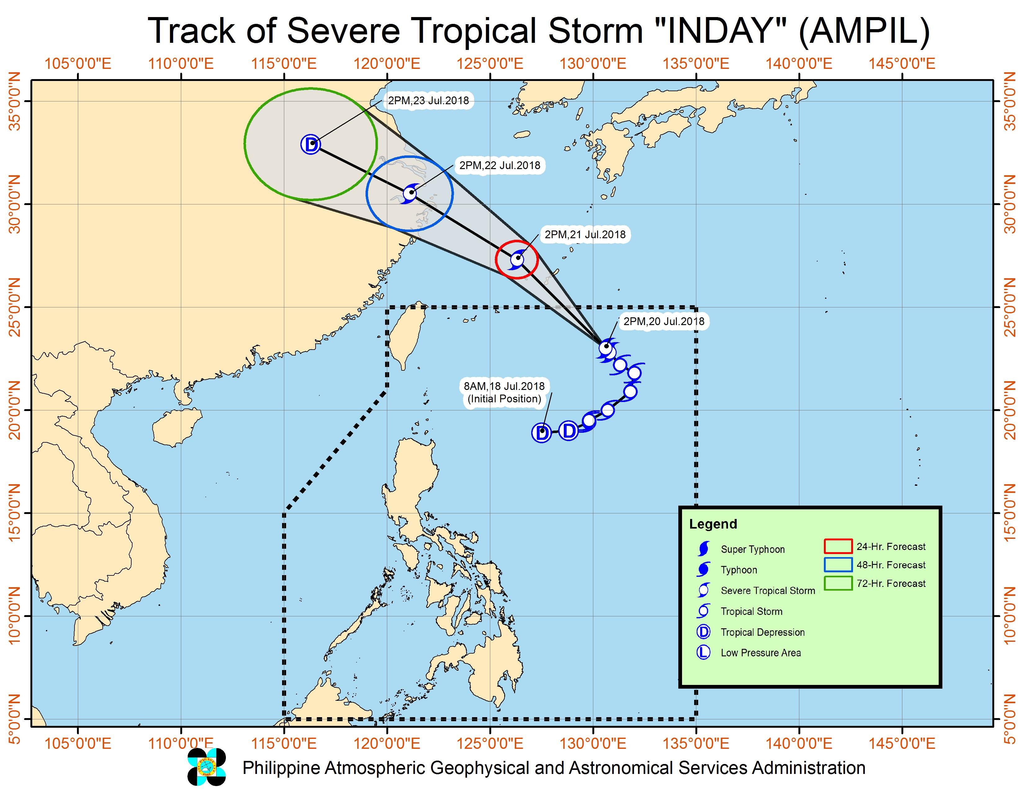
MANILA, Philippines – Severe Tropical Storm Inday (Ampil) maintained its strength but slowed down on Friday afternoon, July 20, while still enhancing the southwest monsoon or hanging habagat.
In a bulletin released past 4 pm on Friday, state weather bureau PAGASA said Inday continues to have maximum winds of 90 kilometers per hour (km/h) and gustiness of up to 115 km/h.
The severe tropical storm is already 945 kilometers east northeast of Basco, Batanes, slowly moving northwest. Inday is not expected to make landfall in the Philippines, and there are no areas under tropical cyclone warning signals.
While Inday won’t hit land, it continues to enhance the southwest monsoon. This means it will still be rainy in Luzon until Saturday, July 21.
More monsoon rain is expected in Metro Manila, the Ilocos Region, the Cordillera Administrative Region, Bataan, Zambales, Bulacan, Pampanga, Tarlac, and Nueva Ecija.
There will also be occasional rainshowers in the rest of Luzon, ranging from light to heavy, due to the southwest monsoon.
Residents of Luzon, especially those in low-lying or in mountainous areas, should stay on alert for possible flash floods and landslides. Floods have already hit various areas. (READ: FAST FACTS: Tropical cyclones, rainfall advisories)
The Visayas and Mindanao, which are not affected by the southwest monsoon, will only have isolated rainshowers or thunderstorms. But PAGASA advised residents of these island regions to still watch out for possible flash floods and landslides, in case thunderstorms dump heavy rain.
PAGASA also issued a gale warning at 5 pm on Friday for the western seaboards of Northern Luzon and Central Luzon. This means coastal waters off Ilocos Sur, La Union, Pangasinan, the western coast of Ilocos Norte, Zambales, and Bataan will be rough to very rough, with wave heights reaching 2.5 meters to 4.5 meters.
Because of this gale warning, fishing boats and other small sea vessels are advised not to sail, while larger sea vessels should watch out for big waves.
Based on its latest forecast track, Inday is expected to leave the Philippine Area of Responsibility (PAR) on Saturday morning.
Inday is the Philippines’ 9th tropical cyclone for 2018. The country usually gets an average of 20 tropical cyclones per year. (READ: LIST: PAGASA’s names for tropical cyclones in 2018)
Aside from Inday, PAGASA also continues to monitor a low pressure area (LPA) outside PAR. This LPA is now located 435 kilometers west of Laoag City, Ilocos Norte, and might enter PAR over the weekend. Updates will be given in PAGASA’s succeeding bulletins.
PAGASA declared the start of the rainy season last June 8. – Rappler.com
Add a comment
How does this make you feel?
There are no comments yet. Add your comment to start the conversation.