SUMMARY
This is AI generated summarization, which may have errors. For context, always refer to the full article.
What’s the weather like in your area? Report the situation through Rappler’s Agos or tweet us at @rapplerdotcom.
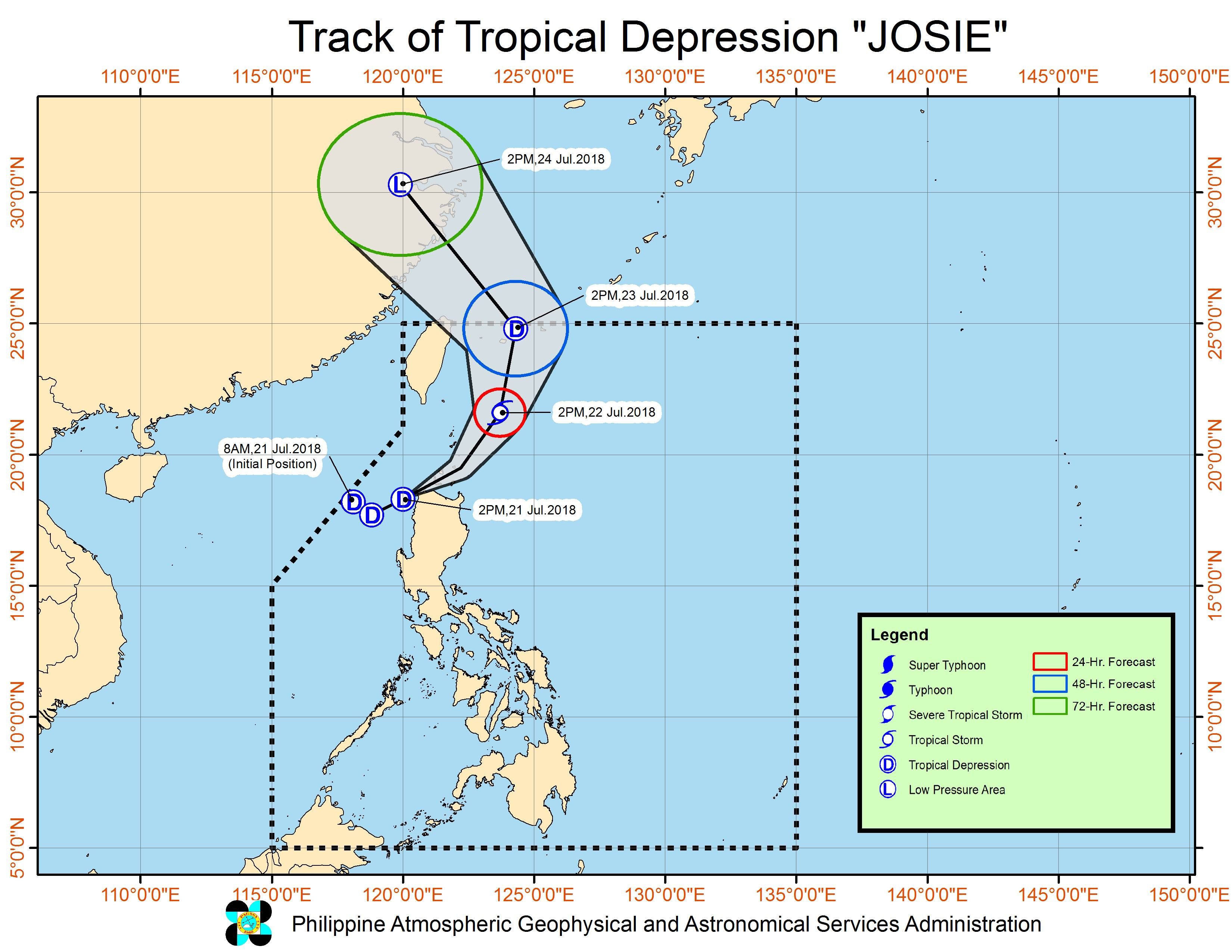
MANILA, Philippines – Tropical Depression Josie accelerated late Saturday afternoon, July 21, and is now nearing the Burgos-Pagudpud area in Ilocos Norte, where it may or may not make landfall.
In a bulletin released past 5 pm on Saturday, state weather bureau PAGASA said Josie is already 55 kilometers northwest of Laoag City, Ilocos Norte, moving east northeast at a faster 25 kilometers per hour (km/h) from the previous 15 km/h.
PAGASA said Josie is “about to make a close approach” to the Burgos-Pagudpud area, but it is still uncertain if landfall would occur.
The tropical depression continues to have maximum winds of 55 km/h and gustiness of up to 65 km/h.
Signal number 1 is still raised over:
- Batanes
- northern Cagayan including the Babuyan Group of Islands
- Ilocos Norte
- northern part of Ilocos Sur
- Apayao
- northern part of Abra
Josie is also enhancing the southwest monsoon or hanging habagat.
Moderate to heavy rain will persist in the Ilocos Region, the Cordillera Administrative Region, Batanes, the Babuyan Group of Islands, Zambales, Tarlac, and Nueva Ecija.
Scattered rainshowers, ranging from light to heavy, are also being experienced in Metro Manila, Calabarzon, the rest of Central Luzon, the rest of Cagayan Valley, Oriental Mindoro, and Occidental Mindoro due to the southwest monsoon.
Areas affected by Josie and the southwest monsoon should be on alert for possible flash floods and landslides. This is especially important as lands in parts of Luzon have already been saturated from the heavy rainfall in the past week. (READ: Monsoon rains increase risk of landslides in Baguio, Benguet)
Dagupan City in Pangasinan has already been placed under a state of calamity due to massive floods triggered by rain from the southwest monsoon.
PAGASA also warned that sea travel remains risky in the seaboards of Northern Luzon and in the western seaboard of Central Luzon, especially in areas under signal number 1. (READ: FAST FACTS: Tropical cyclones, rainfall advisories)
Based on its latest forecast track, Josie is expected to leave the Philippine Area of Responsibility (PAR) on Monday afternoon, July 23. That’s the day of President Rodrigo Duterte’s 3rd State of the Nation Address (SONA).
Josie is the Philippines’ 10th tropical cyclone for 2018. The country usually gets an average of 20 tropical cyclones per year. (READ: LIST: PAGASA’s names for tropical cyclones in 2018)
Josie comes on the heels of Severe Tropical Storm Inday (Ampil), which left PAR at 1 am on Saturday. Inday did not make landfall in the Philippines, but it enhanced the southwest monsoon.
PAGASA declared the start of the rainy season last June 8.
– Rappler.com
Add a comment
How does this make you feel?
There are no comments yet. Add your comment to start the conversation.