SUMMARY
This is AI generated summarization, which may have errors. For context, always refer to the full article.
What’s the weather like in your area? Report the situation through Rappler’s Agos or tweet us at @rapplerdotcom.
MANILA, Philippines – Tropical Depression Luis slowed down on Thursday evening, August 23, after making landfall in southern Taiwan. Taiwan is within the Philippine Area of Responsibility (PAR).
In a bulletin issued 11 pm on Thursday, the Philippine Atmospheric, Geophysical, and Astronomical Services Administration (PAGASA) said Luis is now 385 kilometers north northwest of Basco, Batanes, moving west at a slower 10 kilometers per hour (km/h) from the previous 15 km/h.
It continues to have maximum winds of 55 km/h and gustiness of up to 90 km/h.
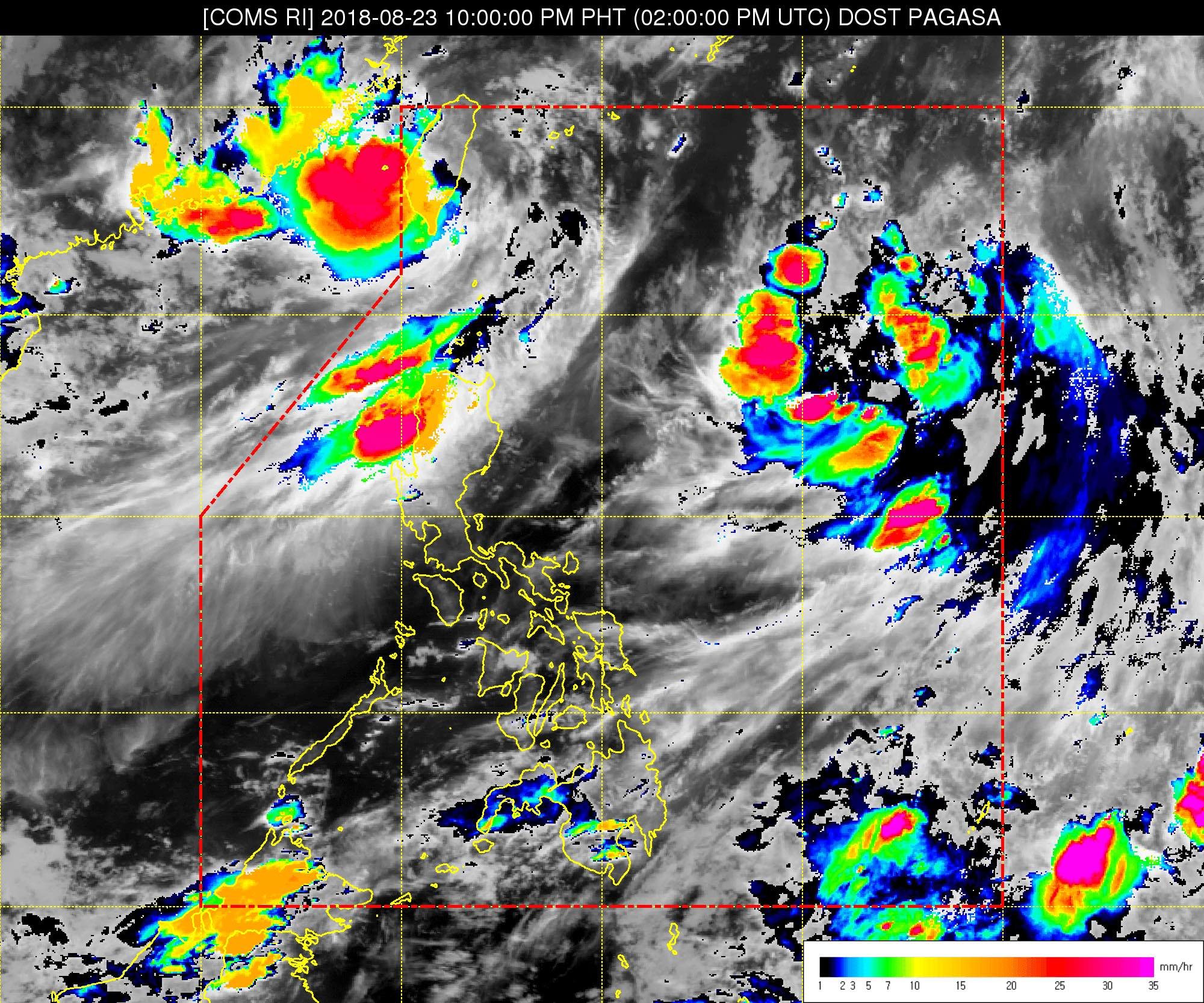
Luis also made landfall in the vicinity of Kaohsiung, Taiwan, at 8 am on Thursday. Taiwan, given its proximity to the Philippines, is inside PAR – the area set by the World Meteorological Organization for PAGASA to monitor. Weather disturbances inside PAR directly or indirectly affect the Philippines.
In the case of Luis, it is not expected to directly affect any part of the country, so there are no areas under tropical cyclone warning signals. But Luis will enhance the southwest monsoon or hanging habagat.
The southwest monsoon will trigger moderate to heavy rain in the Ilocos Region, the Cordillera Administrative Region, Batanes, and the Babuyan Group of Islands on Friday, August 24.
Residents of those areas should watch out for possible flash floods and landslides. (READ: FAST FACTS: Tropical cyclones, rainfall advisories)
The rest of the country, not affected by the southwest monsoon, will only have localized thunderstorms on Friday.
PAGASA also warned that travel is risky in the seaboards of Northern Luzon and Central Luzon.
A gale warning was issued at 5 pm on Thursday for Batanes, the Babuyan Group of Islands, the northern coast of Cagayan, Ilocos Norte, Ilocos Sur, La Union, Pangasinan, Zambales, Bataan, the eastern coast of Cagayan, Isabela, and Aurora.
This means seas off these areas are rough to very rough, with wave heights reaching 2.6 meters to 4.5 meters.
Fishermen and others with small vessels were advised not to set sail in areas covered by the gale warning. Larger vessels should watch out for big waves.
Based on its latest forecast track, Luis will leave PAR on Friday night.
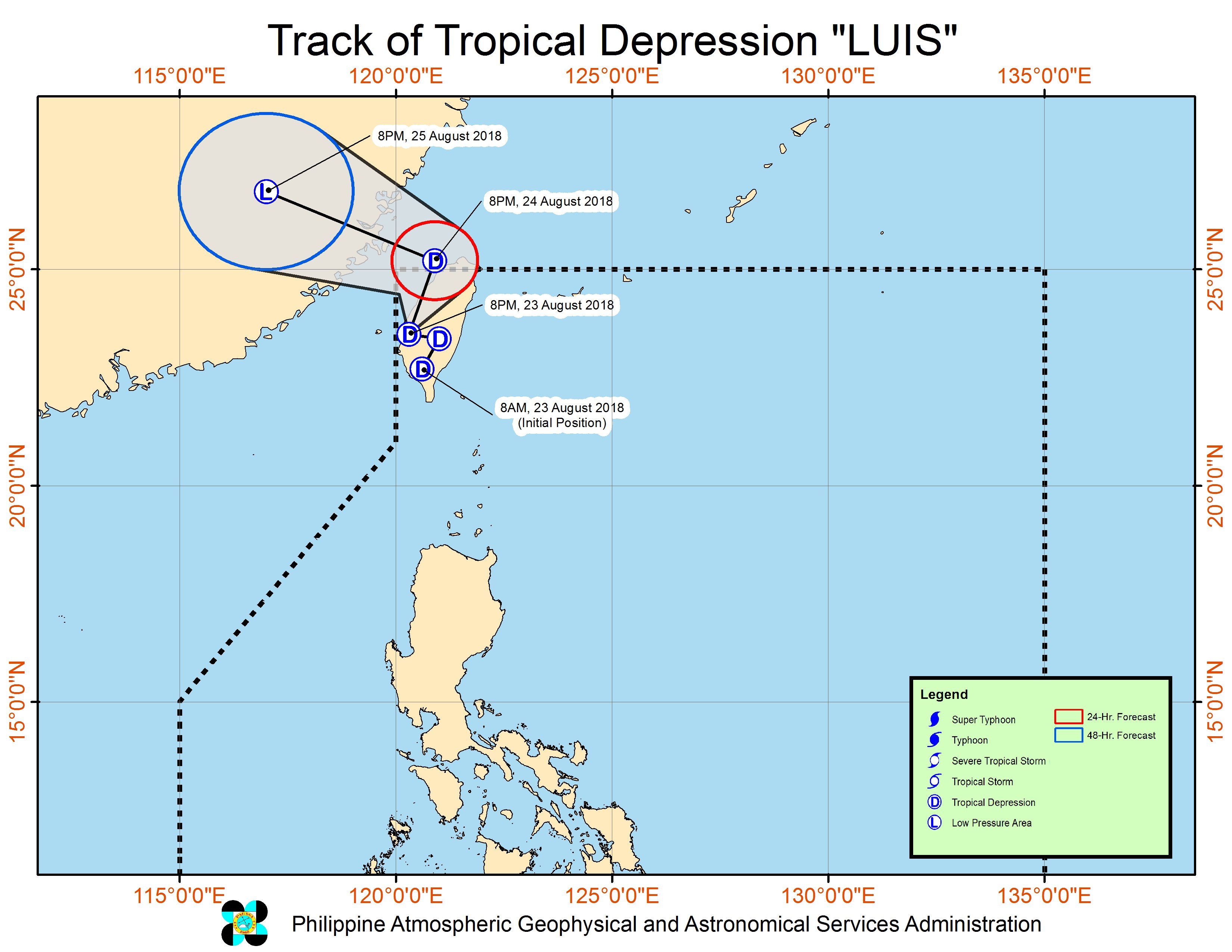
Meanwhile, PAGASA is also monitoring a low pressure area (LPA) located 1,000 kilometers east of Aparri, Cagayan.
This LPA could develop into a tropical depression within the next 24 to 48 hours. If it becomes a tropical depression, it would be named Maymay. (READ: LIST: PAGASA’s names for tropical cyclones in 2018)
Luis is the Philippines’ 12th tropical cyclone for 2018. The Philippines usually gets an average of 20 tropical cyclones per year.
PAGASA declared the start of the rainy season last June 8. – Rappler.com
Add a comment
How does this make you feel?
![[In This Economy] A counter-rejoinder in the economic charter change debate](https://www.rappler.com/tachyon/2024/04/TL-counter-rejoinder-apr-20-2024.jpg?resize=257%2C257&crop=267px%2C0px%2C720px%2C720px)
![[Vantage Point] Joey Salceda says 8% GDP growth attainable](https://www.rappler.com/tachyon/2024/04/tl-salceda-gdp-growth-04192024.jpg?resize=257%2C257&crop_strategy=attention)
![[ANALYSIS] A new advocacy in race to financial literacy](https://www.rappler.com/tachyon/2024/04/advocacy-race-financial-literacy-April-19-2024.jpg?resize=257%2C257&crop_strategy=attention)


There are no comments yet. Add your comment to start the conversation.