SUMMARY
This is AI generated summarization, which may have errors. For context, always refer to the full article.
What’s the weather like in your area? Report the situation through Rappler’s Agos or tweet us at @rapplerdotcom.
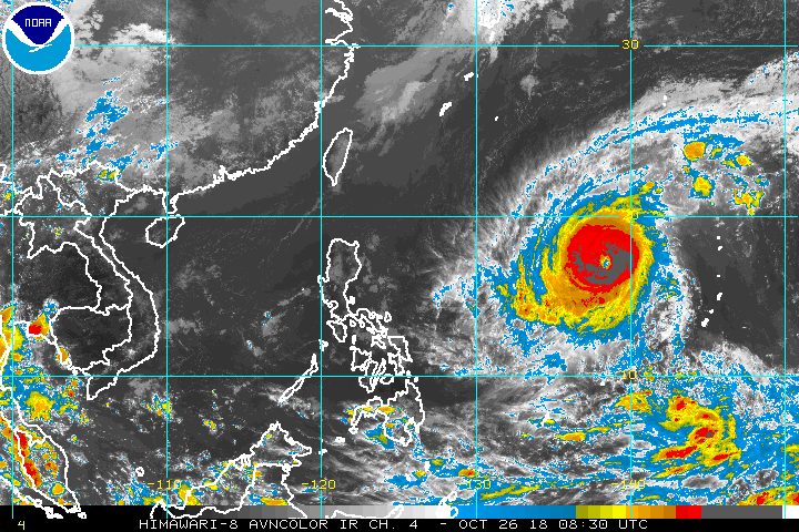
MANILA, Philippines – Typhoon Yutu slightly strengthened on Friday afternoon, October 26, while making its way to the Philippine Area of Responsibility (PAR).
In a Facebook Live video past 5 pm on Friday, the Philippine Atmospheric, Geophysical, and Astronomical Services Administration (PAGASA) said Yutu is now 1,815 kilometers east of Northern Luzon, moving west at 20 kilometers per hour (km/h).
Yutu now has maximum winds of 185 km/h from the previous 180 km/h and gustiness of up to 225 km/h from the previous 220 km/h. But PAGASA said it is unlikely to reach the super typhoon category, which requires maximum winds exceeding 220 km/h. (READ: FAST FACTS: Tropical cyclones, rainfall advisories)
If Yutu maintains its speed, it would likely enter PAR on Saturday morning, October 27. When it enters, it will be given the local name Rosita. (READ: LIST: PAGASA’s names for tropical cyclones in 2018)
PAGASA said tropical cyclone warning signals may be raised as early as Sunday evening, October 28, in the eastern parts of Northern Luzon and Central Luzon.
Moderate to heavy rain from Yutu or Rosita is expected to hit Northern Luzon and Central Luzon beginning Monday evening, October 29.
Sea travel will also be risky in the seaboards of Northern Luzon and Central Luzon beginning Sunday, and in the eastern seaboard of Southern Luzon starting Monday.
PAGASA advised everyone to continue monitoring updates on the typhoon.
So far, the Philippines has had 17 tropical cyclones in 2018. The country usually gets an average of 20 tropical cyclones per year.
Northeast monsoon
PAGASA also announced that the northeast monsoon or hanging amihan season has officially begun.
The northeast windflow or winds coming from the northeast will “further intensify and become dominant over most parts of the country,” according to PAGASA.
This also means “surges of cold temperatures” are expected, especially before dawn or early morning.
At the moment, the northeast monsoon is affecting Northern Luzon.
Isolated rainshowers are expected in the Ilocos Region, Cordillera Administrative Region, and Cagayan Valley on Saturday. But PAGASA said there will be “no significant impact.”
The rest of the country will also have localized thunderstorms on Saturday, mostly in the afternoon or evening. Flash floods and landslides are possible if the thunderstorms bring heavy rain.
PAGASA declared the start of the rainy season last June 8. – Rappler.com
Add a comment
How does this make you feel?
There are no comments yet. Add your comment to start the conversation.