SUMMARY
This is AI generated summarization, which may have errors. For context, always refer to the full article.
What’s the weather like in your area? Report the situation through Rappler’s Agos or tweet us at @rapplerdotcom.
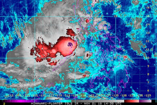
MANILA, Philippines – Signal No. 1 remains raised only in Palawan, including Cuyo Island and the Calamian Group of Islands, as of late Wednesday evening, November 21.
In a bulletin issued 11 pm on Wednesday, the Philippine Atmospheric, Geophysical, and Astronomical Services Administration (PAGASA) said Samuel is already 140 kilometers west southwest of Cuyo or 140 kilometers east northeast of Puerto Princesa City, Palawan.
The tropical depression slightly slowed down on its way to the province, now moving west at 25 kilometers per hour (km/h) from the previous 30 km/h.
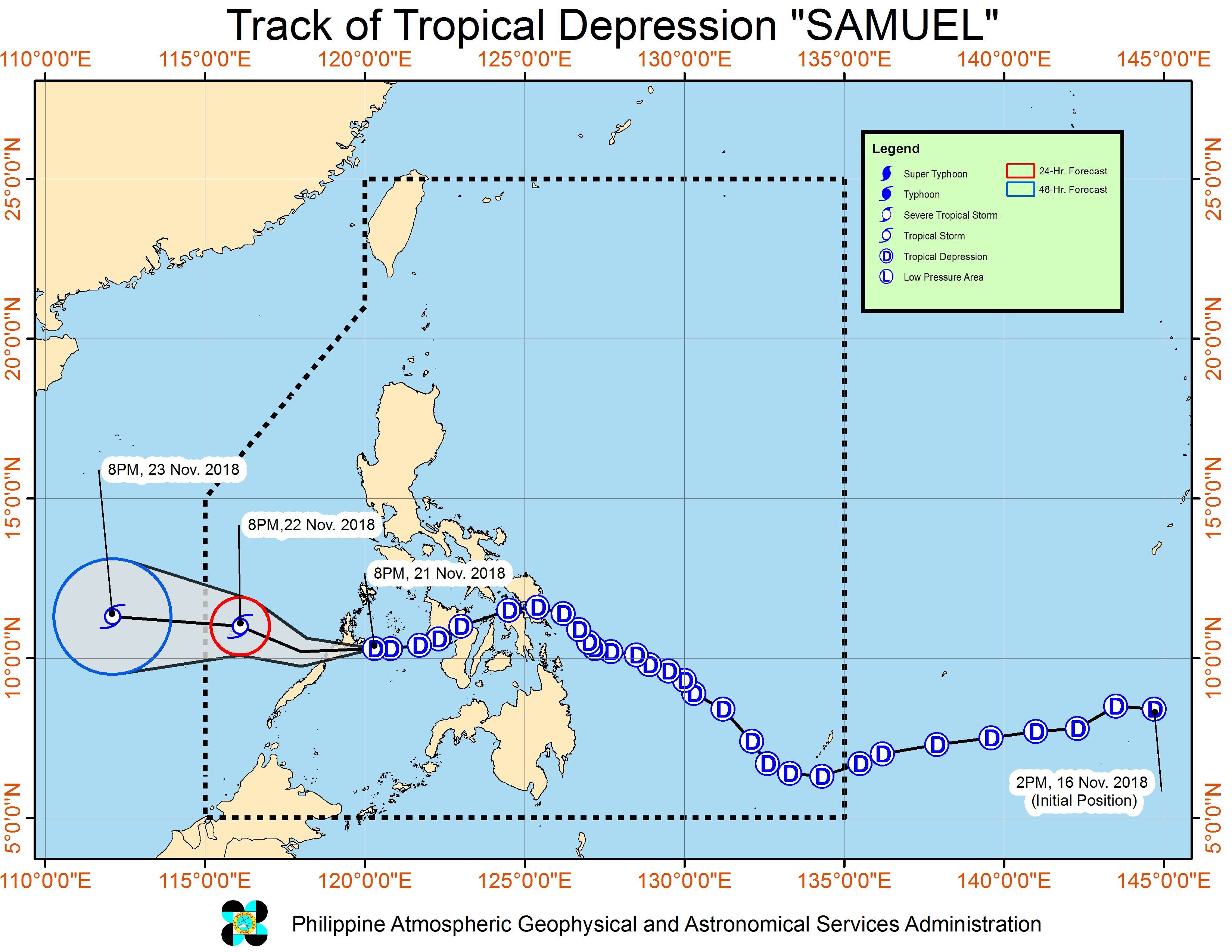
It is expected to make landfall in the northern part of Palawan early Thursday morning, November 22, possibly between 2 am and 4 am.
Samuel already made landfall 5 times in the Visayas on Wednesday morning, particularly in the following areas:
- Borongan City, Eastern Samar – 2 am
- Daram, Samar – 4 am
- Caibiran, Biliran – 5 am
- Calubian, Leyte – 5:30 am
- Barotac Nuevo, Iloilo – 9 am
The tropical depression continues to have maximum winds of 45 km/h and gustiness of up to 60 km/h.
PAGASA warned that moderate to heavy rain may trigger flash floods and landslides in Palawan, including Cuyo and Calamian. Residents should stay on alert, especially if they live near rivers, in low-lying communities, or in mountainous regions. (READ: FAST FACTS: Tropical cyclones, rainfall advisories)
Fishermen and others with small sea vessels are also advised not to set sail in Palawan and in the eastern seaboards of Luzon.
A gale warning was issued at 5 pm on Wednesday for Isabela, Aurora, Camarines Norte, Camarines Sur, Catanduanes, the eastern coast of Sorsogon, and the eastern coast of Quezon including Polillo Island.
Seas off those areas are rough to very rough, with wave heights reaching 2.6 meters to 4.5 meters.
Thousands of passengers have been stranded in various ports in the country.
If Samuel maintains its speed, it would exit the Philippine Area of Responsibility (PAR) either on Thursday evening or before dawn on Friday, November 23.
Samuel is the Philippines’ 19th tropical cyclone for 2018. The country usually gets an average of 20 tropical cyclones per year. (READ: LIST: PAGASA’s names for tropical cyclones in 2018)
Aside from Samuel, PAGASA is also monitoring a tropical storm outside PAR, with the international name Man-yi.
Tropical Storm Man-yi is already 2,375 kilometers east of Mindanao, moving west northwest over the Pacific Ocean at 35 km/h. It has maximum winds of 80 km/h and gustiness of up to 95 km/h.
At the moment, Man-yi only has a slim chance of entering PAR. If it does enter, PAGASA said it appears unlikely that it would make landfall. But this forecast could still change so keep monitoring updates.
Meanwhile, the northeast monsoon or hanging amihan will still bring isolated light rains to the Ilocos Region, Cordillera Administrative Region, and Cagayan Valley on Thursday. But PAGASA said there will be “no significant impact.”
The rest of the country not affected by Samuel or the northeast monsoon will only have localized thunderstorms on Thursday. But flash floods and landslides are possible if the thunderstorms become severe.
PAGASA declared the start of the rainy season last June 8. – Rappler.com
Add a comment
How does this make you feel?
There are no comments yet. Add your comment to start the conversation.