SUMMARY
This is AI generated summarization, which may have errors. For context, always refer to the full article.
What’s the weather like in your area? Report the situation through Rappler’s Agos or tweet us at @rapplerdotcom.
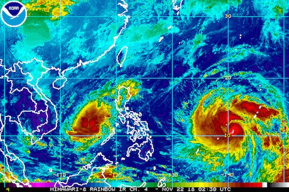
MANILA, Philippines – Man-yi, the tropical storm outside the Philippine Area of Responsibility (PAR), intensified into a severe tropical storm late Thursday morning, November 22. This is as Tropical Depression Samuel, inside PAR, continues to move away from the country.
In a press briefing at 11:30 am, the Philippine Atmospheric, Geophysical, and Astronomical Services Administration (PAGASA) said Severe Tropical Storm Man-yi is already 1,790 kilometers east of Mindanao.
It is still moving west northwest over the Pacific Ocean at a relatively fast 45 kilometers per hour (km/h).
Man-yi now has maximum winds of 105 km/h from the previous 85 km/h and gustiness of up to 130 km/h from the previous 105 km/h. It is expected to strengthen further into a typhoon within the next 48 hours.
Man-yi might enter PAR on Sunday, November 25, or Monday, November 26. If it does, it would be given the local name Tomas.
Man-yi or the potential Tomas is unlikely to make landfall, so far. But the public is advised to monitor updates in case this forecast changes. (READ: FAST FACTS: Tropical cyclones, rainfall advisories)
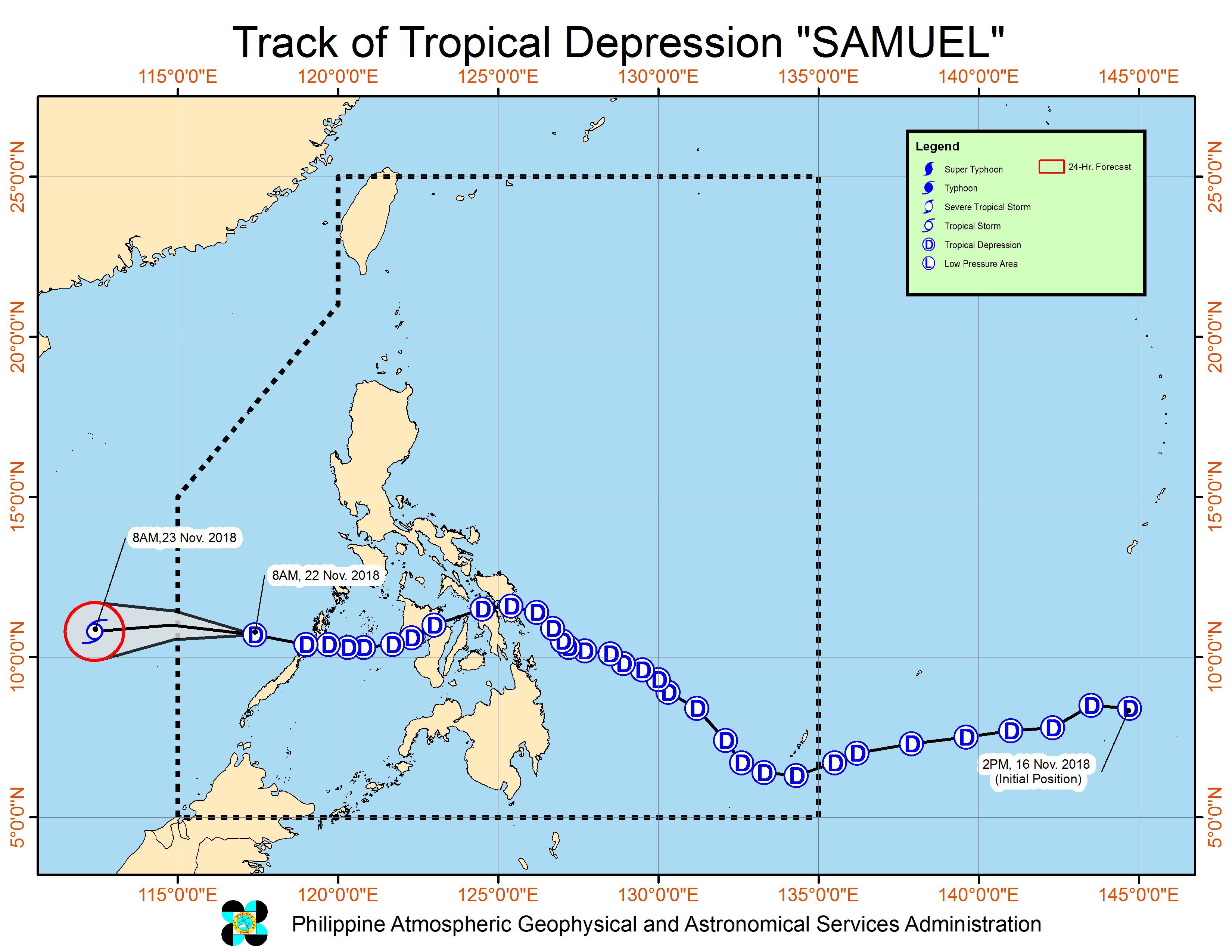
Meanwhile, Samuel is already 240 kilometers west northwest of Puerto Princesa City, Palawan. It is moving west over the West Philippine Sea at a slightly faster 30 km/h from the previous 25 km/h.
Samuel also slightly intensified as it makes its way out of PAR. The tropical depression now has maximum winds of 55 km/h from the previous 45 km/h, while its gustiness remains at 65 km/h.
There are no more areas under Signal No. 1.
But PAGASA warned that fishermen and others with small sea vessels are still advised not to set sail in the northern and western seaboards of Luzon.
A gale warning was issued at 5 am on Thursday for Ilocos Norte, Ilocos Sur, Batanes, Babuyan, Calayan, and the northern coast of Cagayan.
Seas off those areas are rough to very rough, with wave heights reaching 2.6 meters to 4.5 meters.
Thousands of passengers have been stranded in various ports in the country.
If it maintains its speed, Samuel would leave PAR on Thursday evening.
The tropical depression had made landfall 6 times, in the following areas:
Wednesday, November 21
- Borongan City, Eastern Samar – 2 am
- Daram, Samar – 4 am
- Caibiran, Biliran – 5 am
- Calubian, Leyte – 5:30 am
- Barotac Nuevo, Iloilo – 9 am
Thursday, November 22
-
Roxas, Palawan – 1 am
Samuel is the Philippines’ 19th tropical cyclone for 2018. The country usually gets an average of 20 tropical cyclones per year. (READ: LIST: PAGASA’s names for tropical cyclones in 2018)
PAGASA declared the start of the rainy season last June 8. – Rappler.com
Add a comment
How does this make you feel?
There are no comments yet. Add your comment to start the conversation.