SUMMARY
This is AI generated summarization, which may have errors. For context, always refer to the full article.
What’s the weather like in your area? Report the situation through Rappler’s Agos or tweet us at @rapplerdotcom.
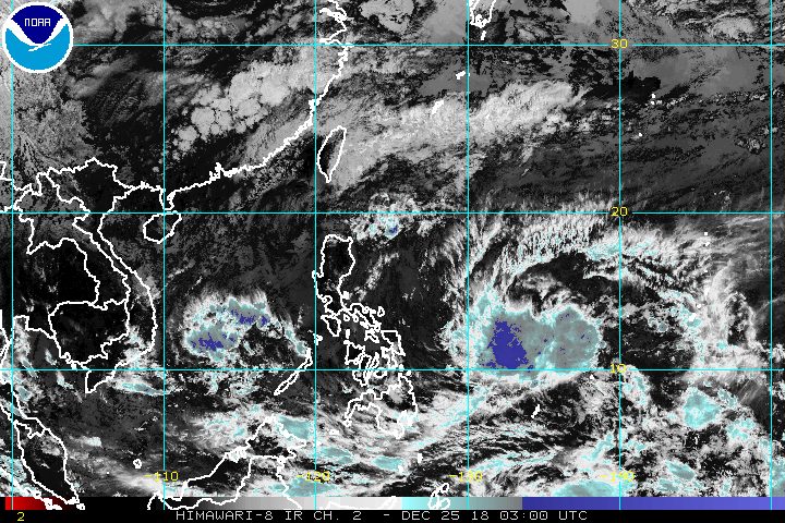
MANILA, Philippines – The first low pressure area (LPA) that forecasters have been monitoring already left the Philippine Area of Responsibility (PAR), but another one is set to enter on Christmas or the day after.
In a bulletin released around noon on Tuesday, December 25, the Philippine Atmospheric, Geophysical, and Astronomical Services Administration (PAGASA) said the first LPA is already 495 kilometers west northwest of Puerto Princesa City, Palawan, or outside PAR.
This LPA is no longer affecting any part of the country, after earlier bringing light to heavy rain.
But another LPA is coming, now located 1,025 kilometers east of Mindanao. It could enter PAR and develop into a tropical depression within the next 24 to 36 hours.
If it does become a tropical depression, it would be given the local name Usman, the Philippines’ 21st tropical cyclone for 2018. The country’s average number of tropical cyclones per year is 20. (READ: LIST: PAGASA’s names for tropical cyclones in 2018)
PAGASA earlier said that one to two tropical cyclones could enter or develop within PAR in December.
At the moment, the potential tropical cyclone’s track remains uncertain. But forecasters earlier predicted that it could affect Caraga, Eastern Visayas, and Bicol. Its possible landfall may be in the Samar-Bicol area on Friday, December 28.
The public should continue monitoring updates in case the forecast changes.
Northeast monsoon
Meanwhile, the northeast monsoon or hanging amihan is affecting Luzon on Christmas.
Batanes and the Babuyan Group of Islands should expect light to moderate rain, which may bring flash floods and landslides.
The rest of Luzon will have light rain, but PAGASA said there will be “no significant impact.” (READ: FAST FACTS: Tropical cyclones, rainfall advisories)
Still due to the northeast monsoon, a gale warning was issued at 5 am on Tuesday for Batanes, Calayan, Babuyan, Ilocos Norte, and the northern coast of Cagayan.
Seas off those areas are rough to very rough, with wave heights reaching 2.8 meters to 4.5 meters.
PAGASA advised fishermen and others with small vessels not to set sail in areas covered by the gale warning. Larger vessels should watch out for big waves.
PAGASA declared the start of the rainy season last June 8. – Rappler.com
Add a comment
How does this make you feel?
There are no comments yet. Add your comment to start the conversation.