SUMMARY
This is AI generated summarization, which may have errors. For context, always refer to the full article.
What’s the weather like in your area? Report the situation through Rappler’s Agos or tweet us at @rapplerdotcom.
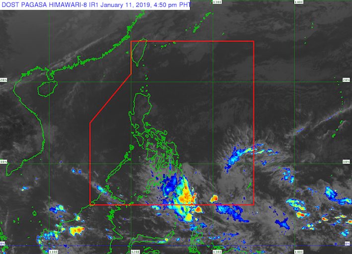
MANILA, Philippines – A low pressure area (LPA) was spotted outside the Philippine Area of Responsibility (PAR) on Friday, January 11.
In a bulletin issued 4 pm on Friday, the Philippine Atmospheric, Geophysical, and Astronomical Services Administration (PAGASA) said the LPA is 1,400 kilometers east southeast of Mindanao.
This LPA has a slim chance of developing into a tropical depression, so far.
But the trough or extension of the LPA began bringing scattered rainshowers and thunderstorms to Mindanao on Friday, which will continue on Saturday, January 12.
The rain, ranging from light to heavy, might trigger flash floods and landslides. PAGASA advised residents to be on alert. (READ: FAST FACTS: Tropical cyclones, rainfall advisories)
The Philippines gets an average of 20 tropical cyclones per year. The forecast for January is zero to one tropical cyclone. (READ: LIST: PAGASA’s names for tropical cyclones in 2019)
Meanwhile, the northeast monsoon or hanging amihan will affect Luzon and the Visayas on Saturday.
There will be light rain, but PAGASA does not expect any “significant impact.”
Due to the surge of the northeast monsoon, however, a gale warning was issued at 5 pm on Friday for the eastern coast of the Camarines provinces, Catanduanes, the eastern coast of Sorsogon, Northern Samar, Eastern Samar, the eastern coast of the Surigao provinces, the Dinagat Islands, Siargao, and the eastern coast of Davao Oriental.
Seas off those areas are rough to very rough, with wave heights reaching 2.8 meters to 4.5 meters.
PAGASA advised fishermen and others with small vessels not to set sail in areas covered by the gale warning. Larger vessels should watch out for big waves. – Rappler.com
Add a comment
How does this make you feel?


There are no comments yet. Add your comment to start the conversation.