SUMMARY
This is AI generated summarization, which may have errors. For context, always refer to the full article.
What’s the weather like in your area? Tweet us at @rapplerdotcom.
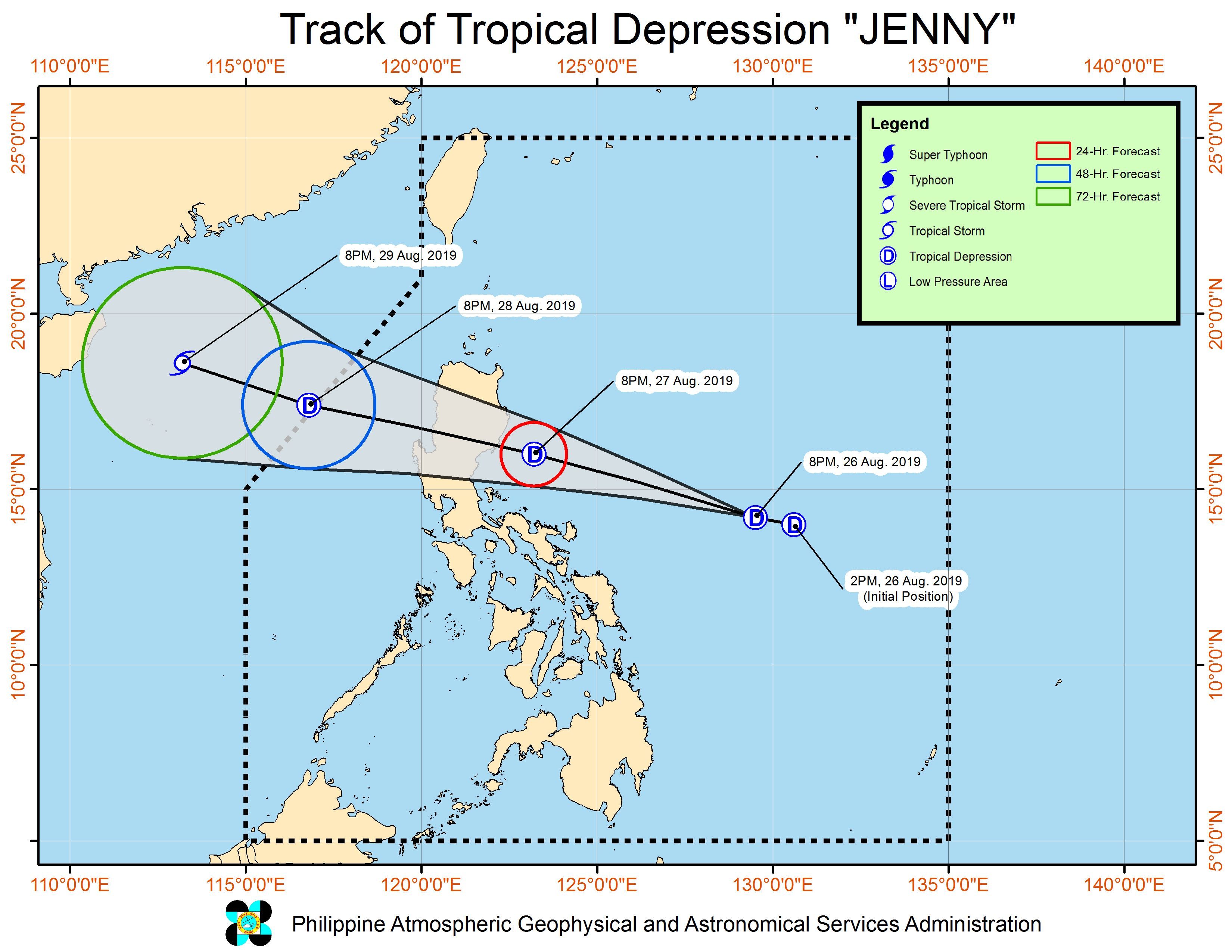
MANILA, Philippines – More areas were placed under Signal No. 1 as Tropical Depression Jenny slightly intensified over the Philippine Sea on Monday evening, August 26.
In a bulletin issued past 11 pm on Monday, the Philippine Atmospheric, Geophysical, and Astronomical Services Administration (PAGASA) said Tropical Depression Jenny now has maximum winds of 55 kilometers per hour (km/h) from the previous 45 km/h and gustiness of up to 70 km/h from the previous 55 km/h.
It is expected to remain a tropical depression during its stay inside the Philippine Area of Responsibility (PAR).
Jenny is already 530 kilometers east of Virac, Catanduanes. It slowed down and shifted direction, now moving west at 20 km/h. It was previously moving northwest at 25 km/h.
There are now 20 areas in Luzon under a tropical cyclone wind signal.
Signal No. 1 (winds of 30 km/h to 60 km/h)
- Cagayan
- Isabela
- Quirino
- Nueva Vizcaya
- Apayao
- Abra
- Kalinga
- Mountain Province
- Ifugao
- Benguet
- Ilocos Norte
- Ilocos Sur
- La Union
- Pangasinan
- Aurora
- Nueva Ecija
- Tarlac
- northern part of Zambales
- northern part of Quezon including Polillo Island
- Catanduanes
PAGASA warned areas under Signal No. 1 to prepare for potentially strong winds. It added that gusty conditions may also occur in most of Luzon and the Visayas due to the southwest monsoon or hanging habagat.
In terms of rainfall, here’s the latest on what to expect:
Monday evening, August 26, to Tuesday noon, August 27
- Moderate to heavy rain
- Bicol
- Eastern Visayas
- Cagayan
- Isabela
- Nueva Vizcaya
- Quirino
- Aurora
- Quezon
- Light to heavy rain
- rest of Luzon
- rest of the Visayas
- Zamboanga Peninsula
Tuesday noon to evening, August 27
- Moderate to heavy rain
- Metro Manila
- Central Luzon
- Calabarzon
- Nueva Vizcaya
- Quirino
- Benguet
- Pangasinan
- Light to heavy rain
- rest of Luzon
- Western Visayas
Jenny might make landfall over the eastern coastline of the Isabela-Aurora area on Tuesday evening, August 27, or Wednesday morning, August 28.
PAGASA advised areas affected by Jenny and the southwest monsoon to watch out for possible flash floods and landslides. (READ: FAST FACTS: Tropical cyclones, rainfall advisories)
Travel is also risky in the seaboards of areas under Signal No. 1.
Based on its latest forecast track, Jenny will leave PAR on Wednesday evening.
Jenny is the Philippines’ 10th tropical cyclone for 2019, and the 3rd for August. (READ: LIST: PAGASA’s names for tropical cyclones in 2019)
The country gets an average of 20 tropical cyclones annually, but since 2019 is an El Niño year, only 14 to 18 tropical cyclones are expected.
Below is the estimated number of tropical cyclones from August to December:
- August – 2 to 4
- September – 2 to 4
- October – 2 or 3
- November – 1 or 2
- December – 0 or 1
PAGASA declared the start of the rainy season last June 14. – Rappler.com
Add a comment
How does this make you feel?
There are no comments yet. Add your comment to start the conversation.