SUMMARY
This is AI generated summarization, which may have errors. For context, always refer to the full article.
What’s the weather like in your area? Tweet us at @rapplerdotcom.
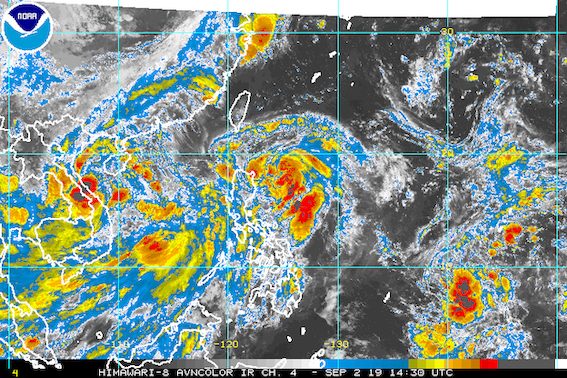
MANILA, Philippines – Tropical Storm Liwayway (Lingling) slightly intensified on Monday evening, September 2, while still moving over the Philippine Sea.
In a bulletin issued 11 pm on Monday, the Philippine Atmospheric, Geophysical, and Astronomical Services Administration (PAGASA) said Liwayway now has maximum winds of 75 kilometers per hour (km/h) from the previous 65 km/h and gustiness of up to 90 km/h from the previous 80 km/h.
It is expected to strengthen further into a severe tropical storm within 48 hours, while still inside the Philippine Area of Responsibility (PAR).
Liwayway is already 300 kilometers northeast of Casiguran, Aurora, or 285 kilometers east of Aparri, Cagayan.
It slightly slowed down and is now moving north northwest at 25 km/h from the previous 30 km/h.
Liwayway remains unlikely to make landfall.
But Batanes is still under Signal No. 1, which means winds of 30 km/h to 60 km/h are expected in the province. PAGASA advised residents to prepare for potentially strong winds.
Both Liwayway and the southwest monsoon or hanging habagat will also continue to trigger rain. Here is the latest on the expected rainfall:
Monday evening, September 2, to Tuesday afternoon, September 3
- Light to heavy rain due to Liwayway
- Cagayan including Babuyan Group of Islands
- Batanes
- Scattered light to heavy rain due to the southwest monsoon
- Ilocos Region
- Central Luzon
- Metro Manila
- Calabarzon
- Mimaropa
- Western Visayas
Tuesday afternoon, September 3, to Wednesday afternoon, September 4
- Light to heavy rain due to Liwayway
- Batanes
- Babuyan Group of Islands
- Scattered light to heavy rain due to the southwest monsoon
- Ilocos Region
- Cordillera Administrative Region
- Central Luzon
PAGASA warned that flash floods and landslides are possible in areas affected by Liwayway and the southwest monsoon. (READ: FAST FACTS: Tropical cyclones, rainfall advisories)
Travel is also risky in the seaboards of Luzon, especially in the seaboard of Batanes.
Based on Liwayway’s latest forecast track, it will leave PAR either on Wednesday, September 4, or on Thursday, September 5.
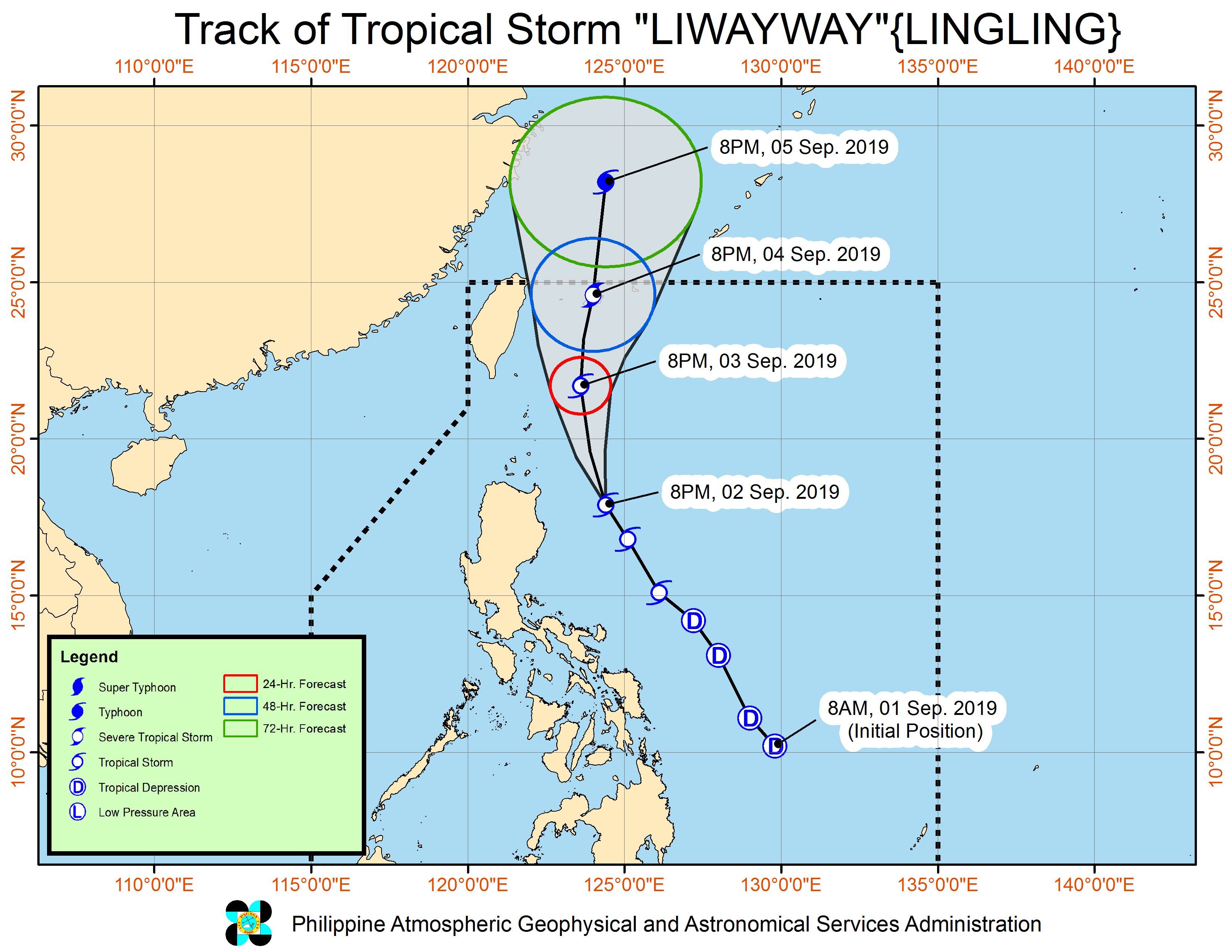
Meanwhile, the low pressure area that PAGASA spotted on Monday afternoon is now outside PAR, at 670 kilometers west of Northern Luzon.
Liwayway is the Philippines’ 12th tropical cyclone for 2019, and the 2nd for September. (READ: LIST: PAGASA’s names for tropical cyclones in 2019)
The country gets an average of 20 tropical cyclones annually, but since 2019 is an El Niño year, only 14 to 18 tropical cyclones are expected.
Below is the estimated number of tropical cyclones from September to December:
- September – 2 to 4
- October – 2 or 3
- November – 1 or 2
- December – 0 or 1
PAGASA declared the start of the rainy season last June 14. – Rappler.com
Add a comment
How does this make you feel?


There are no comments yet. Add your comment to start the conversation.