SUMMARY
This is AI generated summarization, which may have errors. For context, always refer to the full article.
What’s the weather like in your area? Tweet us at @rapplerdotcom.
MANILA, Philippines – Tropical Depression Marilyn slightly weakened on Saturday morning, September 14.
In a briefing past 11 am on Saturday, the Philippine Atmospheric, Geophysical, and Astronomical Services Administration (PAGASA) said Marilyn now has maximum winds of 45 kilometers per hour (km/h) from the previous 55 km/h and gustiness of up to 55 km/h from the previous 70 km/h.
PAGASA said Marilyn could even weaken into a low pressure area. Redevelopment into a tropical depression, however, is not being ruled out.
Marilyn is already 1,215 kilometers east of Basco, Batanes. It is moving northeast at the same slow pace of 10 km/h.
There are no areas under tropical cyclone wind signals and Marilyn is unlikely to make landfall.
But the southwest monsoon or hanging habagat will continue to bring rain, according to PAGASA. Below is the latest on the expected rainfall.
Saturday, September 14, until Sunday morning, September 15
- Occasional to frequent light to moderate rain, with intermittent heavy rain
- Palawan
- Occidental Mindoro
- Oriental Mindoro
- Western Visayas
- Zamboanga Peninsula
- Sulu Archipelago
- Scattered light to moderate rain, with at times heavy rain
- rest of Mimaropa
- Bicol
- Visayas
Residents of those areas must stay on alert for possible flash floods and landslides. (READ: FAST FACTS: Tropical cyclones, rainfall advisories)
Travel remains risky in the western seaboard of Southern Luzon and the seaboards of the Visayas and Mindanao, especially for small vessels.
Based on Marilyn’s latest forecast track, it might briefly leave PAR on Sunday, September 15, then possibly reenter.
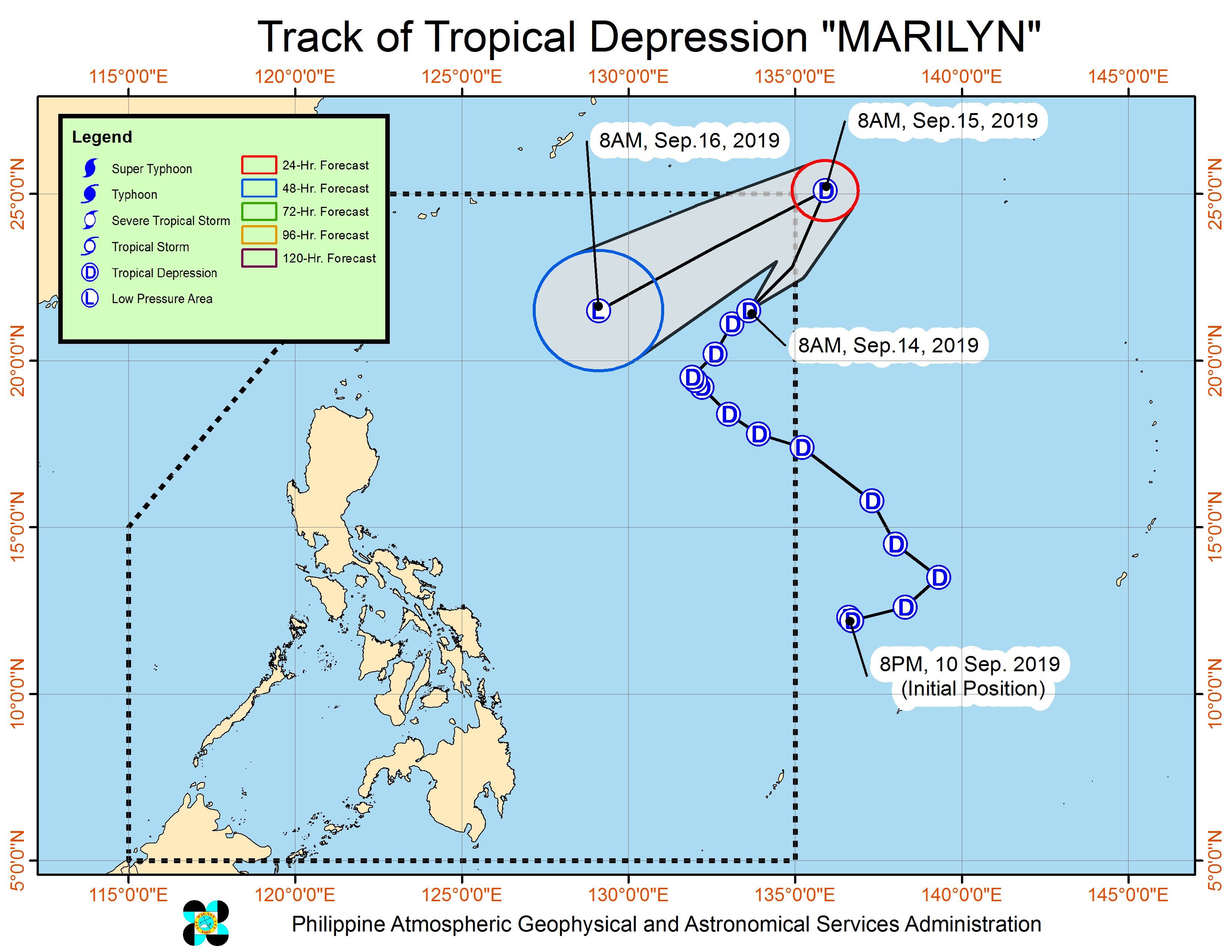
Marilyn is the Philippines’ 13th tropical cyclone for 2019, and the 3rd in September. (READ: LIST: PAGASA’s names for tropical cyclones in 2019)
PAGASA is also monitoring another tropical depression outside PAR, located 2,935 kilometers east of the Visayas.
But PAGASA Weather Specialist Loriedin de la Cruz said it only has a slim chance of entering PAR. It could move northwest instead, away from PAR.
The country gets an average of 20 tropical cyclones annually, but since 2019 is an El Niño year, only 14 to 18 tropical cyclones are expected.
Below is the estimated number of tropical cyclones from September to December:
- September – 2 to 4
- October – 2 or 3
- November – 1 or 2
- December – 0 or 1
PAGASA declared the start of the rainy season last June 14. – Rappler.com
Add a comment
How does this make you feel?
There are no comments yet. Add your comment to start the conversation.