SUMMARY
This is AI generated summarization, which may have errors. For context, always refer to the full article.
What’s the weather like in your area? Tweet us at @rapplerdotcom.
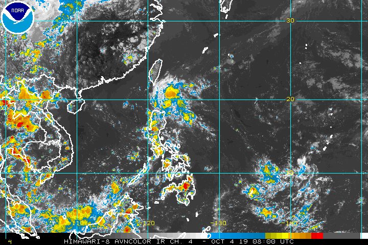
MANILA, Philippines – The state weather bureau is monitoring 3 weather systems as of Friday afternoon, October 4.
These are:
- a low pressure area (LPA) inside the Philippine Area of Responsibility (PAR)
- a shallow LPA (SLPA) outside PAR
- an LPA outside PAR
In a briefing past 4 pm on Friday, the Philippine Atmospheric, Geophysical, and Astronomical Services Administration (PAGASA) said the LPA inside PAR is already 510 kilometers east of Baler, Aurora.
This LPA will bring scattered rainshowers and thunderstorms to the following areas in the next 24 hours:
- Cagayan Valley
- Cordillera Administrative Region
- Aurora
The rest of the country, not affected by the LPA, will continue to have fair weather. But there may be isolated rainshowers or localized thunderstorms.
PAGASA Weather Specialist Gener Quitlong said the LPA could make landfall in extreme Northern Luzon on Saturday, October 5, or Sunday, October 6.
But it is not expected to become a tropical cyclone, and may just dissipate after hitting land. (READ: FAST FACTS: Tropical cyclones, rainfall advisories)
The SLPA outside PAR, meanwhile, is 1,750 kilometers east of Mindanao. It is expected to dissipate as well.
As for the LPA outside PAR, it is still very far, at 4,295 kilometers east of Luzon. According to Quitlong, this LPA could become a tropical cyclone before entering PAR.
“Sa datos po na nakukuha natin ngayon, maaaring by Thursday pa next week (October 10) or Friday (October 11) pa ito makakapasok, or depende po kung hanggang kailan mawawala [ang LPA sa loob ng PAR at SLPA] – itong dalawa ay makakaapekto sa paggalaw ng low pressure area,” said Quitlong.
(Based on the data we’re currently getting, the LPA could enter by Thursday or Friday next week, or depending on when these first two systems will dissipate, since these would affect the movement of the low pressure area.)
The Philippines has had 15 tropical cyclones in 2019. (READ: LIST: PAGASA’s names for tropical cyclones in 2019)
The country gets an average of 20 tropical cyclones annually, but since 2019 is an El Niño year, only 14 to 18 tropical cyclones are expected.
Below is the estimated number of tropical cyclones from October to December:
- October – 2 or 3
- November – 1 or 2
- December – 0 or 1
PAGASA declared the start of the rainy season last June 14. – Rappler.com
Add a comment
How does this make you feel?
There are no comments yet. Add your comment to start the conversation.