SUMMARY
This is AI generated summarization, which may have errors. For context, always refer to the full article.
What’s the weather like in your area? Tweet us at @rapplerdotcom.
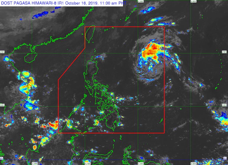
MANILA, Philippines – The low pressure area (LPA) inside the Philippine Area of Responsibility (PAR) developed into a tropical depression at 8 am on Wednesday, October 16. It has been given the local name Perla.
In a briefing past 11 am on Wednesday, the Philippine Atmospheric, Geophysical, and Astronomical Services Administration (PAGASA) said Tropical Depression Perla is 1,190 kilometers east of Baler, Aurora, or 1,120 kilometers east of Casiguran, Aurora.
It is over the Pacific Ocean, moving west northwest at 20 kilometers per hour (km/h).
At the moment, Perla has maximum winds of 45 km/h and gustiness of up to 55 km/h.
PAGASA said Perla is less likely to intensify into a tropical storm, and may even weaken into an LPA again while still inside PAR. (READ: FAST FACTS: Tropical cyclones, rainfall advisories)
There are also no tropical cyclone wind signals raised, so far.
PAGASA Senior Weather Specialist Chris Perez explained that Perla will not yet affect any part of the country on Wednesday and on Thursday, October 17.
But the tropical depression may cause bad weather in the following areas beginning Friday evening, October 18, or Saturday morning, October 19:
- Batanes
- Cagayan including Babuyan Group of Islands
- Apayao

Perla is the Philippines’ 16th tropical cyclone for 2019, and the 1st for October. (READ: LIST: PAGASA’s names for tropical cyclones in 2019)
The country gets an average of 20 tropical cyclones annually, but since 2019 is an El Niño year, only 14 to 18 tropical cyclones are expected.
Below is the estimated number of tropical cyclones from October to December:
- October – 2 or 3
- November – 1 or 2
- December – 0 or 1
Meanwhile, the northeasterly surface windflow is bringing light rain to Batanes and the Babuyan Group of Islands on Wednesday.
Travel is also risky, especially for small sea vessels, in the northern and western seaboards of Northern Luzon due to the northeasterly surface windflow.
The intertropical convergence zone (ITCZ) is also expected to trigger scattered rainshowers and thunderstorms in Mindanao and Eastern Visayas on Wednesday.
PAGASA defines the ITCZ as a “series of low pressure areas brought about by converging northeast and southeast winds that cause thunderstorms and rainshowers.”
Other parts of the country have generally fair weather, with just isolated rainshowers or localized thunderstorms, mostly in the afternoon or evening.
PAGASA declared the start of the rainy season last June 14. – Rappler.com
Add a comment
How does this make you feel?
There are no comments yet. Add your comment to start the conversation.