SUMMARY
This is AI generated summarization, which may have errors. For context, always refer to the full article.
What’s the weather like in your area? Tweet us at @rapplerdotcom.
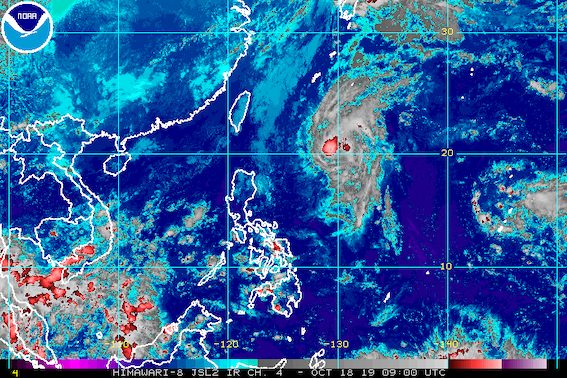
MANILA, Philippines – Tropical Storm Perla (Neoguri) gained more strength as it remained almost stationary or barely moving over the ocean on Friday afternoon, October 18.
In a briefing at 5 pm on Friday, the Philippine Atmospheric, Geophysical, and Astronomical Services Administration (PAGASA) said Perla is still 790 kilometers east of Basco, Batanes.
The tropical storm now has maximum winds of 75 kilometers per hour (km/h) from the previous 65 km/h and gustiness of up to 90 km/h from the previous 80 km/h. But it could eventually weaken back into a tropical depression while still inside the Philippine Area of Responsibility (PAR).
Perla is not expected to make landfall in the country and there are no areas under tropical cyclone wind signals. (READ: FAST FACTS: Tropical cyclones, rainfall advisories)
PAGASA Weather Specialist Aldczar Aurelio explained that a high pressure area prompted Perla to shift direction. The tropical storm had been earlier expected to hit or make a close approach to extreme Northern Luzon.
Though Perla’s track has since changed, PAGASA advised residents and disaster managers in extreme Northern Luzon to continue monitoring updates.
PAGASA said there may be occasional gusty conditions in that area until early next week due to the northeasterly surface windflow.
There may also be isolated light rain, particularly in the following provinces, until Saturday, October 19:
- Batanes
- Ilocos Norte
- Apayao
- Cagayan
Also due to the northeasterly surface windflow, travel remains risky in the seaboards of Northern Luzon, especially for small vessels.
Based on Perla’s latest forecast track, it might leave PAR on Monday, October 21, or on Tuesday, October 22.

Perla is the Philippines’ 16th tropical cyclone for 2019, and the 1st for October. (READ: LIST: PAGASA’s names for tropical cyclones in 2019)
The country gets an average of 20 tropical cyclones annually, but since 2019 is an El Niño year, only 14 to 18 tropical cyclones are expected.
Below is the estimated number of tropical cyclones from October to December:
- October – 2 or 3
- November – 1 or 2
- December – 0 or 1
Meanwhile, the rest of the country, not affected by the northeasterly surface windflow, will still enjoy fair weather. There may just be isolated rainshowers or localized thunderstorms, mostly in the afternoon or evening.
PAGASA declared the start of the rainy season last June 14. – Rappler.com
Add a comment
How does this make you feel?
There are no comments yet. Add your comment to start the conversation.