SUMMARY
This is AI generated summarization, which may have errors. For context, always refer to the full article.
What’s the weather like in your area? Tweet us at @rapplerdotcom.
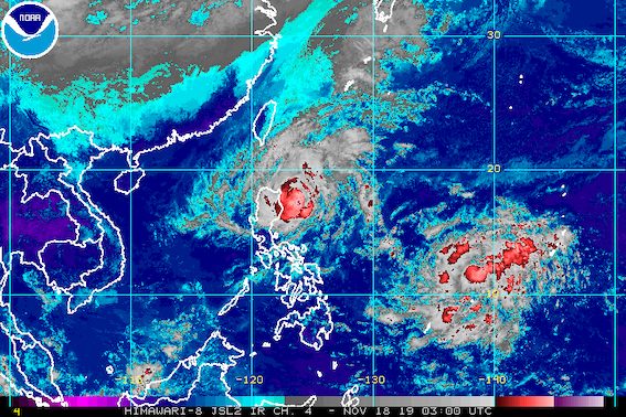
MANILA, Philippines – The northern part of Ilocos Norte was added to the list of areas under Signal No. 2 as Tropical Storm Ramon (Kalmaegi) maintained its course late Monday morning, November 18.
In a bulletin issued 11 am on Monday, the Philippine Atmospheric, Geophysical, and Astronomical Services Administration (PAGASA) said Ramon is now 160 kilometers east northeast of Tuguegarao City, Cagayan.
The tropical storm maintained its slow pace, moving west northwest at 10 kilometers per hour (km/h).
It continues to have maximum winds of 85 km/h and gustiness of up to 105 km/h.
These are all the areas under tropical cyclone wind signals:
Signal No. 2 (winds of 61 km/h to 120 km/h)
- Cagayan, including Babuyan Group of Islands
- northern part of Isabela (Sta Maria, San Pablo, Maconacon, Cabagan, Sto Tomas, Quezon, Delfin Albano, Tumauini, Divilacan)
- Apayao
- Kalinga
- northern part of Ilocos Norte (Pagudpud, Burgos, Bangui, Dumalneg, Adams)
Signal No. 1 (winds of 30 km/h to 60 km/h)
- Batanes
- rest of Ilocos Norte
- Ilocos Sur
- Abra
- Mountain Province
- Ifugao
- northern part of Aurora (Dilasag, Casiguran, Dinalungan)
- rest of Isabela
Below is the latest on the expected rainfall.
Monday afternoon, November 18
- Light to moderate rain with occasionally heavy rain
- eastern part of Cagayan
- eastern part of Isabela
- Light to moderate rain with intermittent heavy rain
- rest of Cagayan
- rest of Isabela
- Babuyan Group of Islands
- northern part of Aurora
- Apayao
- Kalinga
- Mountain Province
- Ifugao
- Abra
- Ilocos Norte
Monday evening, November 18
- Moderate rain with occasional to frequent heavy rain
- Cagayan, including Babuyan Group of Islands
- northern part of Isabela
- Apayao
- Light to moderate rain with intermittent heavy rain
- Batanes
- Kalinga
- Abra
- Ilocos Norte
- rest of Isabela
Tuesday, November 19
- Light to moderate rain with occasionally heavy rain
- northern part of Cagayan, including Babuyan Group of Islands
- Batanes
- Apayao
- Ilocos Norte
- Light to moderate rain with intermittent heavy rain
- rest of Cagayan
- Isabela
- Kalinga
- Abra
- Ilocos Sur
Residents of those areas must stay on alert for possible flash floods and landslides. (READ: FAST FACTS: Tropical cyclones, rainfall advisories)
Classes were suspended in some areas for Monday. (READ: #WalangPasok: Class suspensions, Monday, November 18, 2019)
Travel also remains risky, especially for small vessels, in the seaboards of areas under Signal Nos. 1 and 2, the western seaboard of Northern Luzon, and the eastern seaboards of Central Luzon and Southern Luzon.
Based on Ramon’s latest forecast track, it might make landfall in the northern part of Cagayan between Monday evening and Tuesday morning, November 19.
PAGASA said Ramon is likely to intensify further before making landfall, and then gradually weaken after hitting land.
It could leave the Philippine Area of Responsibility (PAR) on Wednesday evening, November 20.
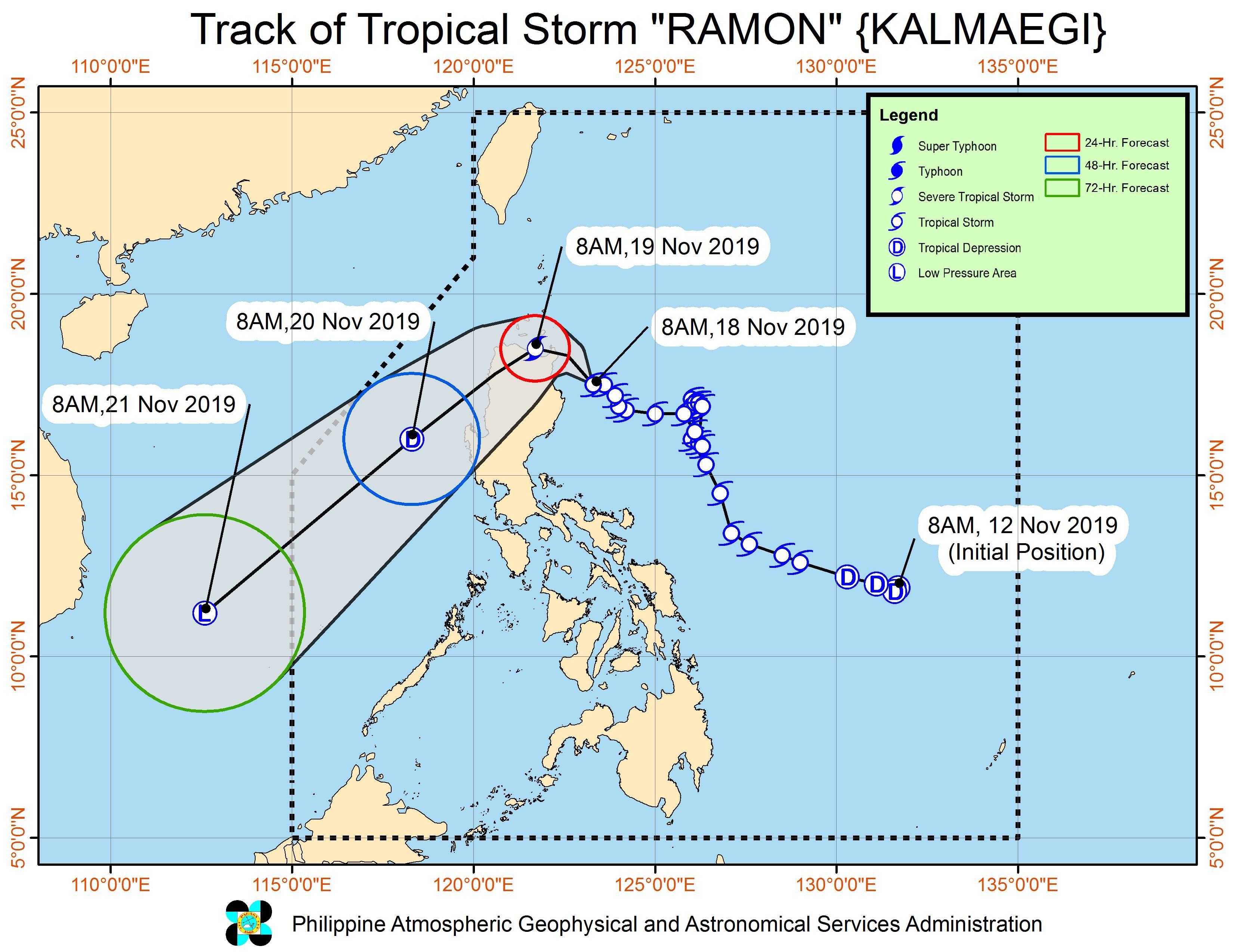
Ramon is the Philippines’ 18th tropical cyclone for 2019, and the 2nd for November.
Meanwhile, the low pressure area outside PAR is now 1,605 kilometers east of Eastern Visayas. It is expected to enter within 24 hours.
If it becomes a tropical depression and enters PAR, it would be given the local name Sarah. (READ: LIST: PAGASA’s names for tropical cyclones in 2019)
The country gets an average of 20 tropical cyclones annually, but since 2019 is an El Niño year, only 14 to 18 tropical cyclones are expected.
Below is the estimated number of tropical cyclones for the last two months of 2019:
- November – 1 or 2
- December – 0 or 1
PAGASA declared the start of the rainy season last June 14. – Rappler.com
Add a comment
How does this make you feel?
There are no comments yet. Add your comment to start the conversation.