SUMMARY
This is AI generated summarization, which may have errors. For context, always refer to the full article.
What’s the weather like in your area? Tweet us at @rapplerdotcom.
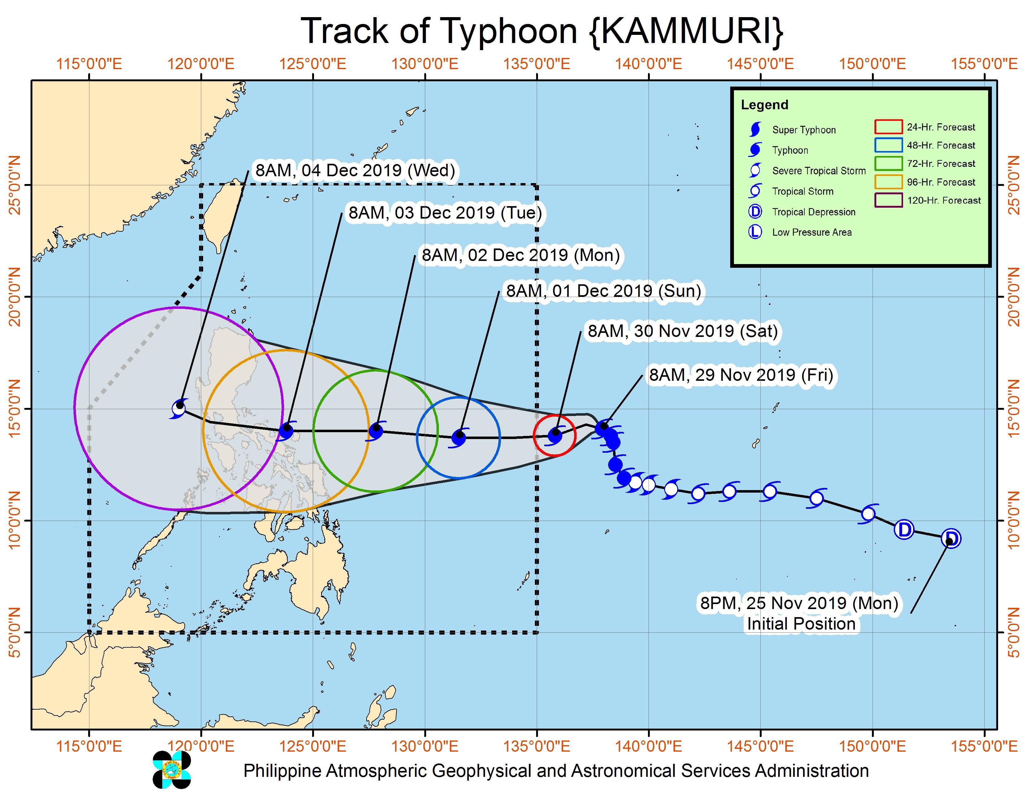
MANILA, Philippines – Typhoon Kammuri is poised to enter the Philippine Area of Responsibility (PAR) on Saturday, November 30.
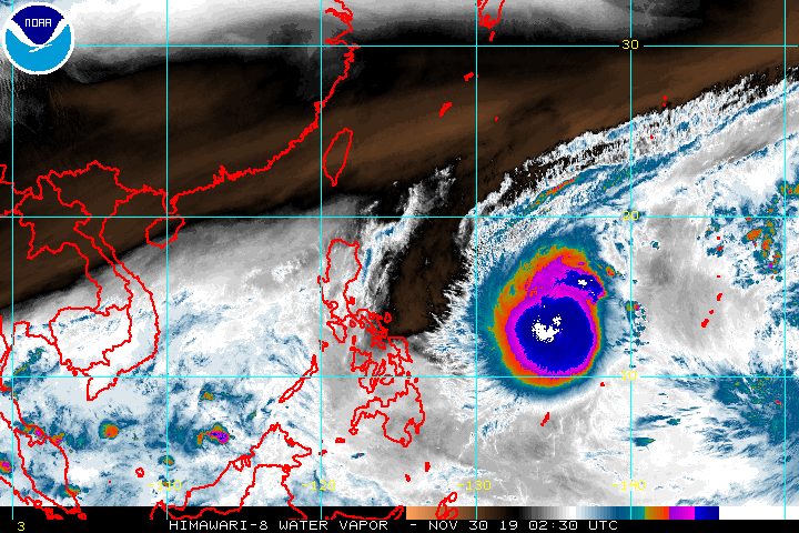
In a briefing past 11 am on Saturday, the Philippine Atmospheric, Geophysical, and Astronomical Services Administration (PAGASA) said Kammuri is already 1,220 kilometers east of Southern Luzon.
It is moving west southwest at 15 kilometers per hour (km/h), slightly slower than its pace of 20 km/h before dawn on Saturday.
Kammuri is also stronger compared to a day ago. It now has maximum winds of 150 kilometers per hour (km/h) from 140 km/h, and gustiness of up to 185 km/h from 170 km/h.
According to PAGASA, Kammuri is likely to intensify further before it makes landfall, still within typhoon category.
“Intensification into a super typhoon is less likely at this time, but not ruled out,” added PAGASA.
A typhoon has maximum winds of 118 km/h to 220 km/h, while a super typhoon has maximum winds exceeding 220 km/h, based on PAGASA’s classification system.
PAGASA Weather Specialist Raymond Ordinario emphasized that Kammuri will be powerful even if it remains to be a typhoon and does not strengthen into a super typhoon.
When Kammuri enters PAR, it will be given the local name Tisoy. (READ: LIST: PAGASA’s names for tropical cyclones in 2019)
Ordinario clarified that when the typhoon enters, it won’t have any immediate, direct effect yet since it is still making its way toward land. Weather on Saturday will still generally be fair, with just isolated rain.
Once Kammuri is already inside, Signal No. 1 may be raised in Northern Samar and Eastern Samar. This means winds of 30 km/h to 60 km/h may be experienced there in 36 hours – an advanced warning given so residents can prepare.
Maritime trips could be canceled once tropical cyclone wind signals are raised as well. (READ: FAST FACTS: Tropical cyclones, rainfall advisories)
Starting Monday, December 2, Kammuri or the potential Tisoy could trigger moderate to heavy rain and thunderstorms in Bicol, Samar, Northern Samar, and Eastern Samar.
Landfall is forecast in the Bicol area on Tuesday, December 3, possibly in Catanduanes.
On Tuesday until Wednesday, December 4, most areas in Central Luzon, Southern Luzon, and Metro Manila will experience strong winds and heavy rain as Kammuri crosses landmass. (READ: Typhoon Kammuri track may be like Glenda in 2014, Reming in 2006)
“Crucial time natin is between Tuesday and Wednesday, so lahat ng paghahanda ay dapat natin isagawa bago pa man umabot ‘yung epekto nga nitong ating papalapit na malakas na bagyo,” Ordinario said.
(Our crucial time is between Tuesday and Wednesday, so we should undertake all preparations before we feel the effects of the strong typhoon approaching our country.)
Some of the areas in the typhoon’s path are serving as venues for the 2019 Southeast Asian (SEA) Games. PAGASA earlier said it is coordinating with the Philippine Southeast Asian Games Organizing Committee for weather updates specifically for the venues.
PAGASA warned that flash floods and landslides are possible, especially in low-lying communities and in mountainous areas. Strong winds could also be destructive.
Kammuri or the potential Tisoy would be the Philippines’ 20th tropical cyclone for 2019.
The country gets an average of 20 tropical cyclones annually. In the earlier part of the year, only 14 to 18 tropical cyclones had been projected since 2019 is an El Niño year.
For the month of December, PAGASA is expecting 0 to 1 tropical cyclone.
Meanwhile, the state weather bureau also spotted a new low pressure area (LPA) outside PAR, more than 3,000 kilometers east of Mindanao.
Ordinario said the LPA could intensify into a tropical depression. It will be monitored in the coming days.
PAGASA declared the start of the rainy season last June 14. – Rappler.com
Add a comment
How does this make you feel?


There are no comments yet. Add your comment to start the conversation.