SUMMARY
This is AI generated summarization, which may have errors. For context, always refer to the full article.
What’s the weather like in your area? Tweet us at @rapplerdotcom.
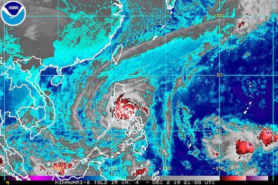
MANILA, Philippines – Typhoon Tisoy (Kammuri) slightly weakened as it continued to cross landmass before dawn on Tuesday, December 3, but it is still expected to dump more rain in parts of Luzon and the Visayas.
In a bulletin issued past 5 am on Tuesday, the Philippine Atmospheric, Geophysical, and Astronomical Services Administration (PAGASA) said Tisoy is already in the vicinity of the municipality of San Pascual in Burias Island, which is in the province of Masbate.
It is again moving at a slightly faster 20 kilometers per hour (km/h) from its speed of 15 km/h when it hit land.
Tisoy had made landfall in Gubat, Sorsogon, at 11 pm on Monday, December 2. Tropical cyclones commonly weaken while crossing land, though in Tisoy’s case, it remains strong nevertheless since it is still a typhoon.
Tisoy now has maximum winds of 155 km/h from 175 km/h at the time of its landfall, and gustiness of up to 235 km/h from 240 km/h. (READ: FAST FACTS: Tropical cyclones, rainfall advisories)
PAGASA said Tisoy’s eyewall is currently bringing violent winds and intense rainfall to Camarines Norte, Camarines Sur, Albay, and Masbate. It will also affect the southern part of Quezon, Romblon, and Marinduque in the next 3 hours.
Tisoy’s eyewall first hit Northern Samar on Monday afternoon.
The World Meteorological Organization defines the eyewall as “an organized band or ring of cumulonimbus clouds that surround the eye” of a tropical cyclone.
Below is the newest list of areas under tropical cyclone wind signals. Areas in Mindanao – Dinagat Islands and Siargao Island – are no longer included.
Signal No. 3 (winds of 121 km/h to 170 km/h)
- Catanduanes
- Camarines Sur
- Albay
- Sorsogon
- Camarines Norte
- Masbate including Ticao Island and Burias Island
- Romblon
- southern part of Quezon (Perez, Alabat, Quezon, Mauban, Sampaloc, Lucban, Tayabas, Pagbilao, Lucena, Sariaya, Candelaria, Dolores, Tiaong, San Antonio, Atimonan, Padre Burgos, Agdangan, Plaridel, Unisan, Pitogo, Gumaca, Lopez, Macalelon, General Luna, Calauag, Guinayangan, Tagkawayan, Buenavista, Mulanay, San Narciso, San Francisco, San Andres)
- Marinduque
- Oriental Mindoro
- Occidental Mindoro including Lubang Island
- Batangas
- Cavite
- Laguna
Signal No. 2 (winds of 61 km/h to 120 km/h)
- Metro Manila
- Bulacan
- Bataan
- Tarlac
- Pampanga
- Nueva Ecija
- southern part of Aurora (Dipaculao, Maria Aurora, Baler, San Luis, Dingalan)
- Rizal
- rest of Quezon including Polillo Island
- Calamian Islands (Coron, Busuanga, Culion, Linapacan)
- Cuyo Islands (Cuyo, Magsaysay, Agutaya)
- Zambales
- Pangasinan
- Northern Samar
- Eastern Samar
- Samar
- Biliran
- Aklan
- Capiz
- Antique
- Iloilo
- Guimaras
- northern part of Negros Occidental (Talisay, Calatrava, Silay, Enrique B Magalona, Victorias, Manapla, Cadiz, Sagay, Escalante, Toboso, Bacolod, Murcia, Salvador Benedicto, San Carlos, Bago, Pulupandan, Valladolid, La Carlota, San Enrique, Pontevedra, La Castellana, Moises Padilla)
- northern part of Cebu (Daanbantayan, Bantayan, Madridejos, Santa Fe, Medellin, Bogo City, San Remigio, Tabogon, Tabuelan, Tuburan, Carmen, Borbon, Sogod, Catmon, Asturias, Camotes Islands)
- Leyte
Signal No. 1 (winds of 30 km/h to 60 km/h)
- southern part of Isabela (Palanan, Dinapigue, San Mariano, San Guillermo, Benito Soliven, Naguilian, Reina Mercedes, Luna, Aurora, Cabatuan, San Mateo, Cauayan City, Alicia, Angadanan, Ramon, San Isidro, Echague, Cordon, Santiago City, Jones, San Agustin)
- Mountain Province
- Ifugao
- Benguet
- Nueva Vizcaya
- Ilocos Sur
- La Union
- Quirino
- rest of Aurora
- northern part of Palawan (El Nido, Taytay, Araceli, Dumaran, San Vicente, Roxas)
- rest of Negros Occidental
- Negros Oriental
- Bohol
- Siquijor
- rest of Cebu
- Southern Leyte
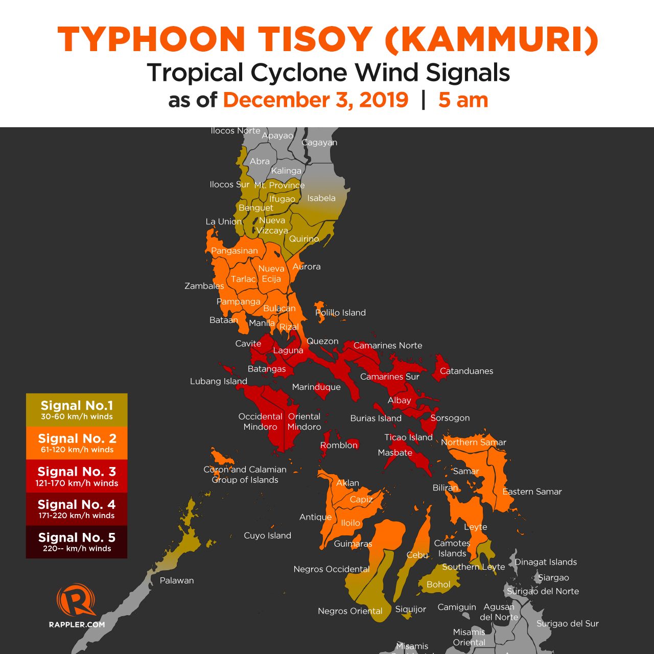
PAGASA added that there may be gusty conditions in areas in Northern Luzon that are not under any tropical cyclone wind signal, due to the northeast monsoon or hanging amihan.
Tuesday is also the day when the peak of rain from Tisoy is expected. Here’s the latest on the projected rainfall:
Between early Tuesday morning and late afternoon, December 3
- Frequent to continuous heavy to intense rain, with isolated torrential rain
- Bicol
- Romblon
- Marinduque
- Occidental Mindoro
- Oriental Mindoro
- Calabarzon
- Metro Manila
- Bataan
- Pampanga
- Bulacan
- Occasional to frequent heavy rain
- rest of Central Luzon
- Intermittent heavy rain
- Eastern Samar
- Northern Samar
- Samar
- Biliran
- Aklan
- Antique
- Capiz
- Iloilo
- Guimaras
- northern part of Negros Occidental
- northern part of Negros Oriental
- Cebu
Between late Tuesday afternoon, December 3, and early Wednesday morning, December 4
- Frequent to continuous heavy rain, with isolated intense rain
- Occidental Mindoro
- Oriental Mindoro
- Metro Manila
- Central Luzon
- Rizal
- northern part of Quezon including Polillo Island
- Occasional heavy rain
- Cagayan Valley
- Cordillera Administrative Region
- Marinduque
- Romblon
- rest of Calabarzon
- Intermittent heavy rain
- Bicol
- Calamian Islands
Residents should stay on alert for possible flash floods and landslides. (READ: Typhoon Kammuri track may be like Glenda in 2014, Reming in 2006)
Storm surges are also possible in certain coastal areas of these provinces:
2 to 3 meters high (6.6 to 9.8 feet)
- Batangas
- Occidental Mindoro
- Oriental Mindoro
- Marinduque
- Romblon
- Ticao Island
- Burias Island
- southern coast of the southern part of Quezon
1 to 2 meters high (3.3 to 6.6 feet)
- Camarines Norte
- northern coast of the southern part of Quezon
- Cavite
- Metro Manila
- Bulacan
- Pampanga
- Bataan
- Zambales (Subic Bay coastal areas)
Travel remains risky, especially for small vessels, in the seaboards of areas under tropical cyclone wind signals, the seaboards of Northern Luzon, the western seaboard of Palawan, and the northern and eastern seaboards of Mindanao. (READ: PH Coast Guard suspends maritime activities due to Typhoon Tisoy)
Numerous domestic and international flights to and from the Philippines have also been canceled due to Tisoy. In Metro Manila, the Ninoy Aquino International Airport will be closed for 12 hours on Tuesday.
Classes for Tuesday are suspended in many areas. (READ: #WalangPasok: Class suspensions, Tuesday, December 3, 2019)
The typhoon also prompted schedule adjustments to be made for some events of the 2019 Southeast Asian Games, which the Philippines is hosting until December 11. Some events were moved to an earlier time, while others were postponed.
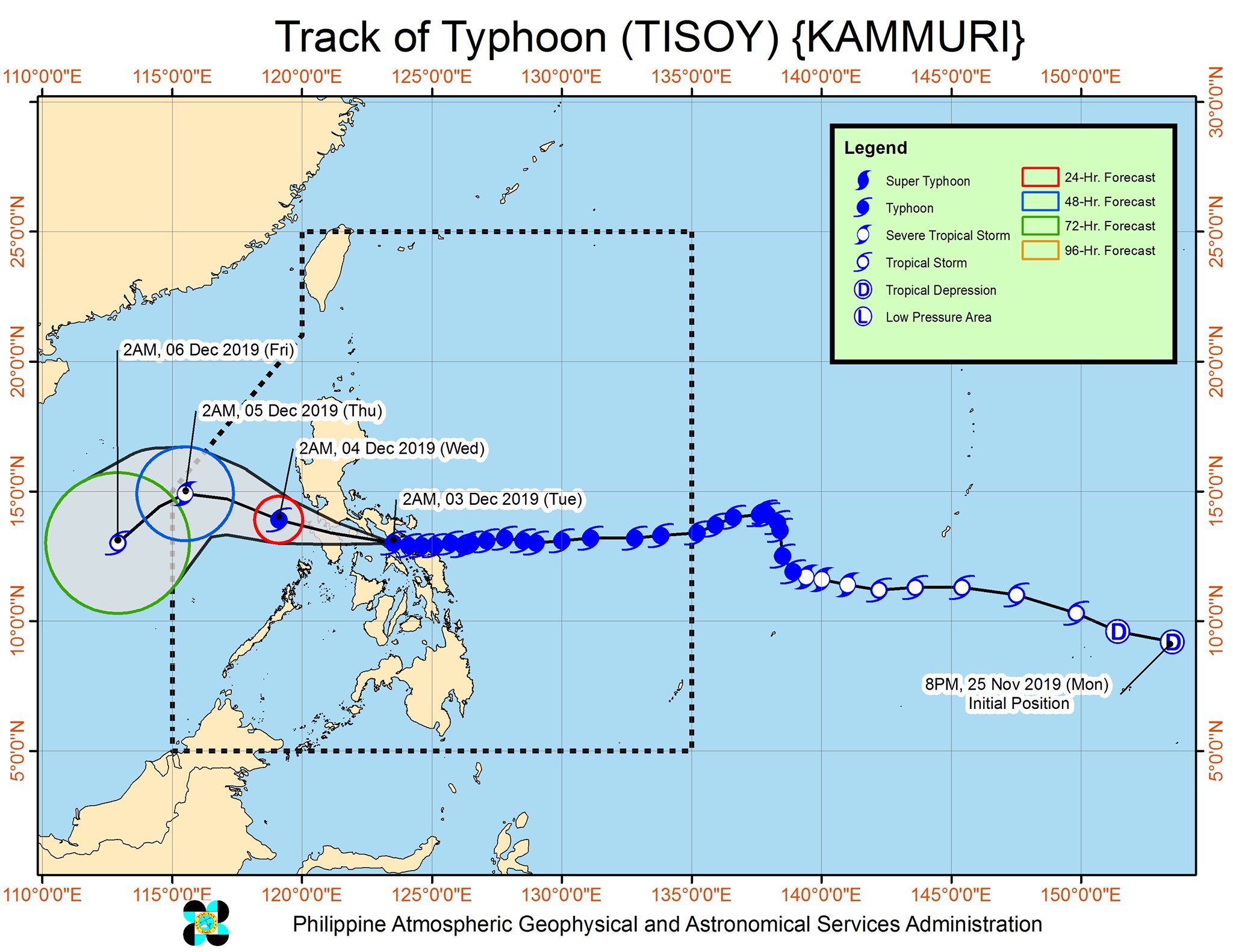
Based on its latest forecast track, Tisoy is expected to leave the Philippine Area of Responsibility on Thursday morning, December 5.
Tisoy is the Philippines’ 20th tropical cyclone for 2019. (READ: LIST: PAGASA’s names for tropical cyclones in 2019)
The country gets an average of 20 tropical cyclones annually. In the earlier part of the year, only 14 to 18 tropical cyclones had been projected since 2019 is an El Niño year.
For the month of December, PAGASA had been expecting 0 to 1 tropical cyclone.
PAGASA declared the start of the rainy season last June 14. – Rappler.com
Add a comment
How does this make you feel?
There are no comments yet. Add your comment to start the conversation.