SUMMARY
This is AI generated summarization, which may have errors. For context, always refer to the full article.
What’s the weather like in your area? Tweet us at @rapplerdotcom.
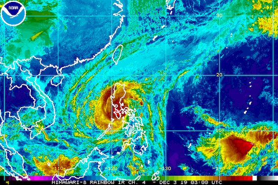
MANILA, Philippines – Typhoon Tisoy (Kammuri) is now moving toward the area of Batangas and the northern part of Oriental Mindoro, after making its 3rd landfall in Marinduque at 8:30 am on Tuesday, December 3.
In a briefing past 11 am on Tuesday, the Philippine Atmospheric, Geophysical, and Astronomical Services Administration (PAGASA) said Tisoy is already 55 kilometers east of Calapan City, Oriental Mindoro.
It is now moving west at a slightly faster 25 kilometers per hour (km/h) from the previous 20 km/h.
Tisoy slightly weakened, though the public should not be complacent since it remains a typhoon. It now has maximum winds of 150 km/h from the previous 155 km/h and gustiness of up to 205 km/h from the previous 235 km/h. (READ: FAST FACTS: Tropical cyclones, rainfall advisories)
Tisoy has made landfall thrice, so far:
- Gubat, Sorsogon – 11 pm on Monday, December 2
- San Pascual, Burias Island, Masbate – 4 am on Tuesday, December 3
- Torrijos, Marinduque – 8:30 am on Tuesday, December 3
Tropical cyclone wind signals have been lifted in several areas, but many others still remain on the list.
Signal No. 3 (winds of 121 km/h to 170 km/h)
- Burias Island
- Romblon
- southern part of Quezon (Perez, Alabat, Quezon, Mauban, Sampaloc, Lucban, Tayabas, Pagbilao, Lucena, Sariaya, Candelaria, Dolores, Tiaong, San Antonio, Atimonan, Padre Burgos, Agdangan, Plaridel, Unisan, Pitogo, Gumaca, Lopez, Macalelon, General Luna, Calauag, Catanauan, Guinayangan, Tagkawayan, Buenavista, Mulanay, San Narciso, San Francisco, San Andres)
- Marinduque
- Oriental Mindoro
- Occidental Mindoro including Lubang Island
- Batangas
- Cavite
- Laguna
Signal No. 2 (winds of 61 km/h to 120 km/h)
- Camarines Sur
- Camarines Norte
- Albay
- Catanduanes
- Sorsogon
- Metro Manila
- Bulacan
- Bataan
- Tarlac
- Pampanga
- Nueva Ecija
- southern part of Aurora (Dipaculao, Maria Aurora, Baler, San Luis, Dingalan)
- Rizal
- rest of Quezon including Polillo Island
- Calamian Islands (Coron, Busuanga, Culion, Linapacan)
- Cuyo Islands (Cuyo, Magsaysay, Agutaya)
- Zambales
- Pangasinan
- Masbate including Ticao Island
- western part of Northern Samar (Lavezares, Allen, Biri, Rosario, Victoria, San Jose, San Isidro, Bobon, Catarman, Lope de Vega)
- northwestern part of Samar (Calbayog, Tagapul-am, Almagro, Sto Niño)
- Aklan
- Capiz
- northern part of Antique (Caluya, Libertad, Pandan, Sebaste, Culasi, Tibiao)
Signal No. 1 (winds of 30 km/h to 60 km/h)
- southern part of Isabela (Palanan, Dinapigue, San Mariano, San Guillermo, Benito Soliven, Naguilian, Reina Mercedes, Luna, Aurora, Cabatuan, San Mateo, Cauayan City, Alicia, Angadanan, Ramon, San Isidro, Echague, Cordon, Santiago City, Jones, San Agustin)
- Benguet
- Nueva Vizcaya
- Ilocos Sur
- La Union
- Quirino
- rest of Aurora
- northern part of Palawan (El Nido, Taytay, Araceli, Dumaran)
- rest of Northern Samar
- rest of Samar
- Biliran
- northern part of Negros Occidental (Talisay, Calatrava, Silay, Enrique B Magalona, Victorias, Manapla, Cadiz, Sagay, Escalante, Toboso, Bacolod, Murcia, Salvador Benedicto, San Carlos, Bago, Pulupandan, Valladolid, La Carlota, San Enrique, Pontevedra, La Castellana, Moises Padilla)
- rest of Antique
- Iloilo
- Guimaras
- Leyte
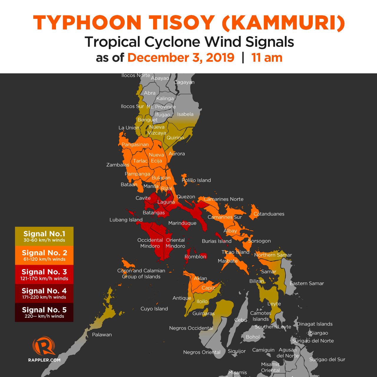
PAGASA added that parts of Northern Luzon may experience gusty conditions even if they are not under any tropical cyclone wind signal. This is due to the northeast monsoon or hanging amihan.
As for rainfall, here’s the latest on what to expect for the rest of Tuesday and on Wednesday, December 4:
Between Tuesday morning and late afternoon, December 3
- Frequent to continuous heavy to intense rain
- Romblon
- Marinduque
- Occidental Mindoro
- Oriental Mindoro
- Calabarzon
- Metro Manila
- Bataan
- Pampanga
- Bulacan
- Occasional to frequent heavy rain
- Bicol
- rest of Central Luzon
- Intermittent heavy rain
- Aklan
- Antique
- Capiz
- northern part of Negros Occidental
- northern part of Negros Oriental
Between late Tuesday afternoon, December 3, and Wednesday morning, December 4
- Frequent to continuous heavy rain, with isolated intense rain
- Occidental Mindoro
- Oriental Mindoro
- Metro Manila
- Central Luzon
- Rizal
- northern part of Quezon including Polillo Island
- Occasional heavy rain
- Cagayan Valley
- Cordillera Administrative Region
- Marinduque
- Romblon
- rest of Calabarzon
- Intermittent heavy rain
- Calamian Islands
Flooding and damage to property have been reported in Bicol. Other areas in the typhoon’s path may also experience floods as well as landslides. (READ: Typhoon Kammuri track may be like Glenda in 2014, Reming in 2006)
Storm surges are also possible in certain coastal areas of these provinces, based on PAGASA’s 8 am storm surge advisory:
Up to 3 meters high (9.8 feet)
- Marinduque
- Occidental Mindoro
- Oriental Mindoro
- Romblon
- Cavite
- Batangas
Travel remains risky, especially for small vessels, in the seaboards of areas under tropical cyclone wind signals, the seaboards of Northern Luzon, the western seaboard of Palawan, the seaboards of the Visayas, and the northern and eastern seaboards of Mindanao.
The Philippine Coast Guard said there were at least 6,449 stranded passengers in Central Visayas, Southern Tagalog, Western Visayas, Bicol, Eastern Visayas, and Southern Visayas as of 4 am on Tuesday.
Hundreds of domestic and international flights to and from the Philippines have also been canceled due to Tisoy. In Metro Manila, the Ninoy Aquino International Airport is closed for 12 hours on Tuesday.
Class and work suspensions were declared by local government units, Malacañang, and other institutions. (READ: #WalangPasok: Class suspensions, Tuesday, December 3, 2019)
Some events of the 2019 Southeast Asian (SEA) Games were either held earlier than scheduled or postponed to a later date. Organizers gave an assurance, however, that the SEA Games will not be extended.
Based on its latest forecast track, Tisoy is expected to leave the Philippine Area of Responsibility on Thursday morning, December 5.
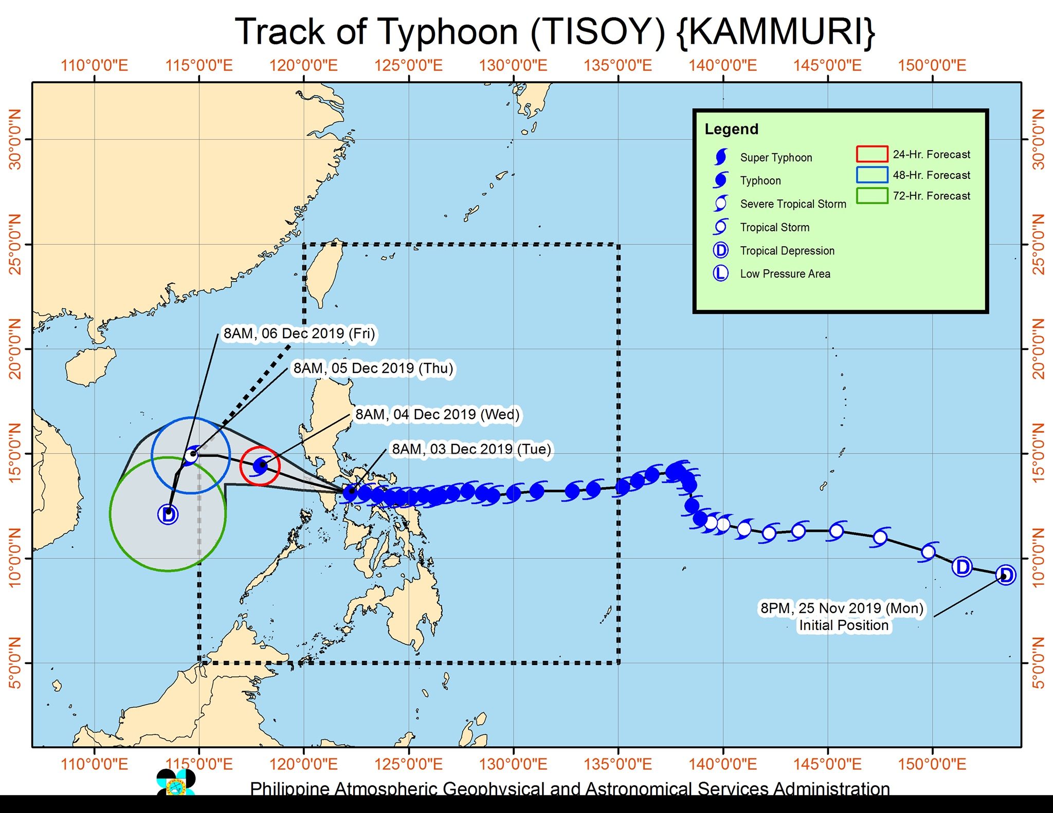
Tisoy is the Philippines’ 20th tropical cyclone for 2019. (READ: LIST: PAGASA’s names for tropical cyclones in 2019)
The country gets an average of 20 tropical cyclones annually. In the earlier part of the year, only 14 to 18 tropical cyclones had been projected since 2019 is an El Niño year.
For the month of December, PAGASA had been expecting 0 to 1 tropical cyclone.
PAGASA declared the start of the rainy season last June 14. – Rappler.com
Add a comment
How does this make you feel?
There are no comments yet. Add your comment to start the conversation.