SUMMARY
This is AI generated summarization, which may have errors. For context, always refer to the full article.

What’s the weather like in your area? Tweet us at @rapplerdotcom.
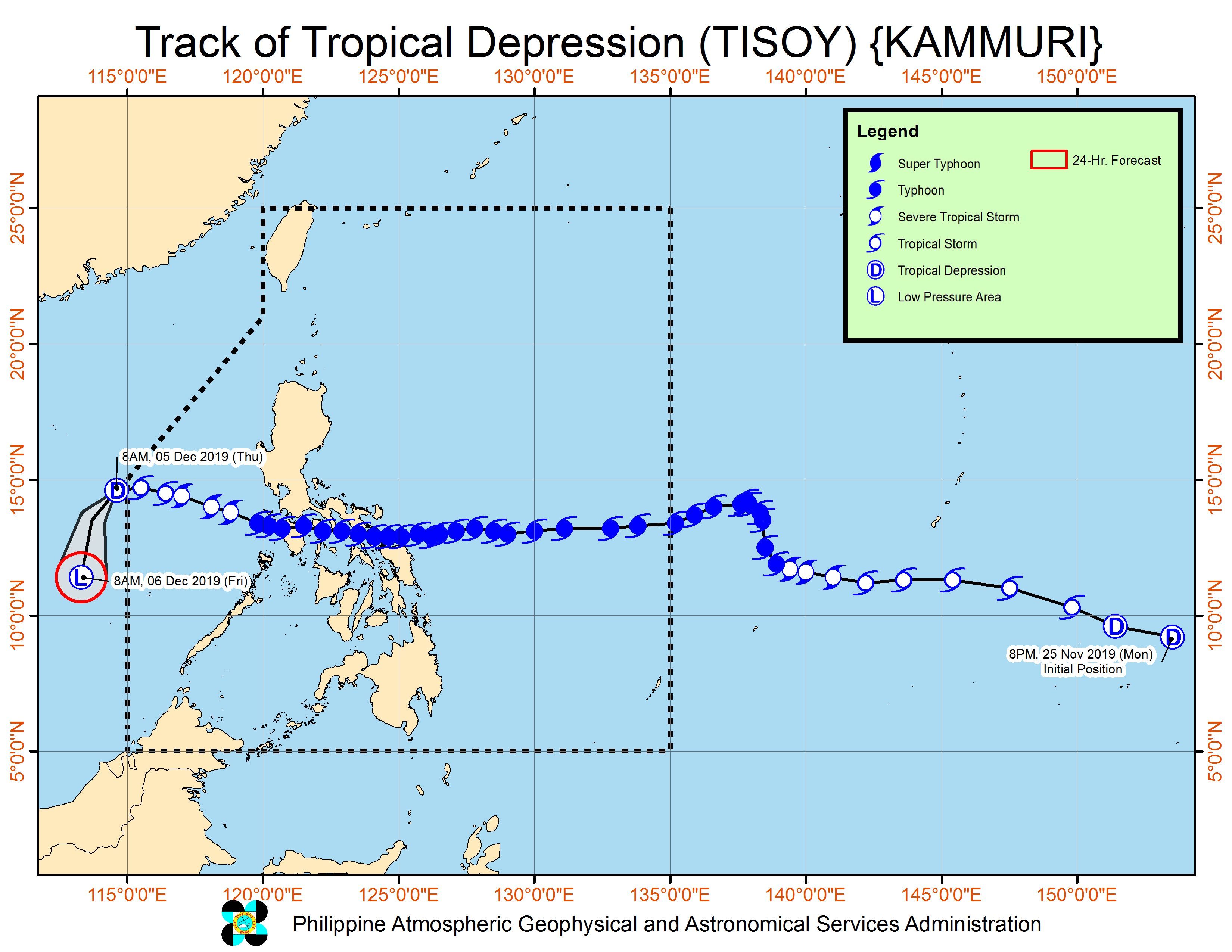
MANILA, Philippines – Tisoy (Kammuri), a typhoon at its peak, was downgraded to a tropical depression as it left the Philippine Area of Responsibility (PAR) at 8 am on Thursday, December 5.
In a briefing past 11 am on Thursday, the Philippine Atmospheric, Geophysical, and Astronomical Services Administration (PAGASA) said Tisoy is already 705 kilometers west northwest of Coron, Palawan, outside PAR.
As Tisoy made its exit, its maximum winds were down to 55 km/h, while its gustiness was 70 km/h.
At the time of its first landfall as a typhoon, Tisoy had maximum winds of 175 km/h and gustiness of up to 240 km/h.
It made landfall in Luzon 4 times, leaving several areas under a state of calamity. These are the places where it made landfall:
- Gubat, Sorsogon – 11 pm on Monday, December 2
- San Pascual, Burias Island, Masbate – 4 am on Tuesday, December 3
- Torrijos, Marinduque – 8:30 am on Tuesday, December 3
- Naujan, Oriental Mindoro – 12:30 pm on Tuesday, December 3
At least 13 people died and 34 others were injured due to Tisoy, said the National Disaster Risk Reduction and Management Council early Thursday morning. The fatalities were from Mimaropa, Eastern Visayas, and Calabarzon.
Tisoy also destroyed crops worth at least P811.5 million in Bicol and Oriental Mindoro.
President Rodrigo Duterte will visit Albay on Thursday. Vice President Leni Robredo, who hails from Bicol, will also visit the region on Saturday, December 7. (READ: #ReliefPH: Help victims of Typhoon Tisoy)
Though Tisoy is no longer inside PAR, there may still be heavy rain due to the surge of the northeast monsoon or hanging amihan and the tail-end of a cold front.
Occasional to frequent heavy rain
- Cagayan Valley
- Ilocos Norte
- Aurora
Intermittent heavy rain
- northern part of Quezon
- rest of Cordillera Administrative Region
PAGASA warned that the heavy rain will continue for the next 12 to 24 hours and “may trigger flooding and landslides in highly susceptible areas.”
Travel also remains risky, especially for small vessels, in the seaboards of Northern Luzon and Central Luzon as well as the eastern and western seaboards of Southern Luzon.
The northeast monsoon may trigger gusty conditions in the northern parts of Northern Luzon too, especially in coastal and mountainous areas.
Meanwhile, PAGASA is monitoring a low pressure area (LPA) outside PAR, at 2,515 kilometers east of Hinatuan, Surigao del Sur.
PAGASA Senior Weather Specialist Chris Perez said the LPA is unlikely to develop into a tropical depression at the moment. Within 24 hours, it could either just dissipate or enter PAR as an LPA. Monitoring will continue.
Tisoy was the Philippines’ 20th tropical cyclone for 2019. (READ: LIST: PAGASA’s names for tropical cyclones in 2019)
The country gets an average of 20 tropical cyclones annually. In the earlier part of the year, only 14 to 18 tropical cyclones had been projected since 2019 is an El Niño year.
For the month of December, PAGASA had been expecting 0 to 1 tropical cyclone.
PAGASA declared the start of the rainy season last June 14. – Rappler.com
Add a comment
How does this make you feel?
There are no comments yet. Add your comment to start the conversation.