SUMMARY
This is AI generated summarization, which may have errors. For context, always refer to the full article.
What’s the weather like in your area? Tweet us at @rapplerdotcom.
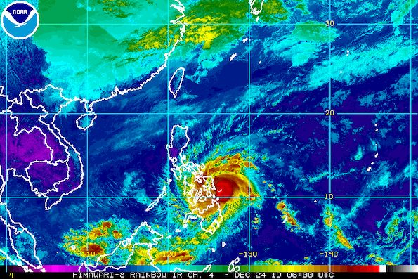
MANILA, Philippines – Ursula (Phanfone) strengthened from a severe tropical storm into a typhoon early Tuesday afternoon, December 24, with the state weather bureau warning that it “endangers” the region of Eastern Visayas.
In a bulletin issued past 2 pm on Tuesday, the Philippine Atmospheric, Geophysical, and Astronomical Services Administration (PAGASA) said Ursula now has maximum winds of 120 kilometers per hour (km/h) from the previous 110 km/h and gustiness of up to 150 km/h from the previous 135 km/h.
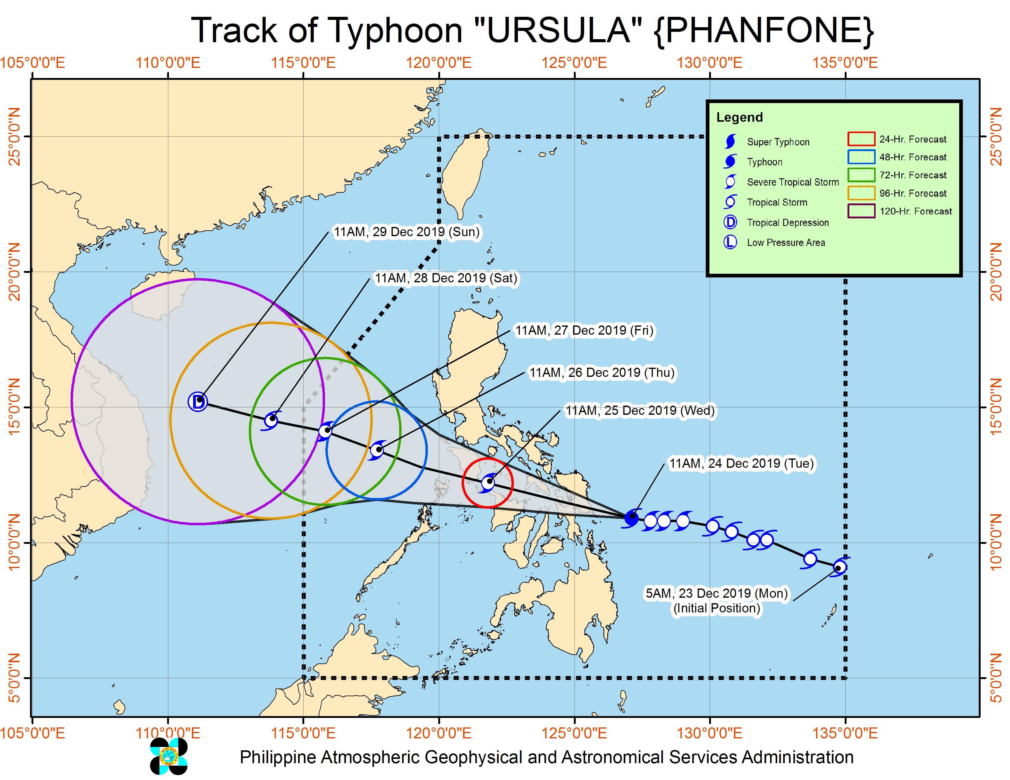
The typhoon is already 95 kilometers east of Guiuan, Eastern Samar, still moving west at 20 km/h.
It is now expected to make landfall specifically in the Borongan-Guiuan area of Eastern Samar between 4 pm and 6 pm on Tuesday.
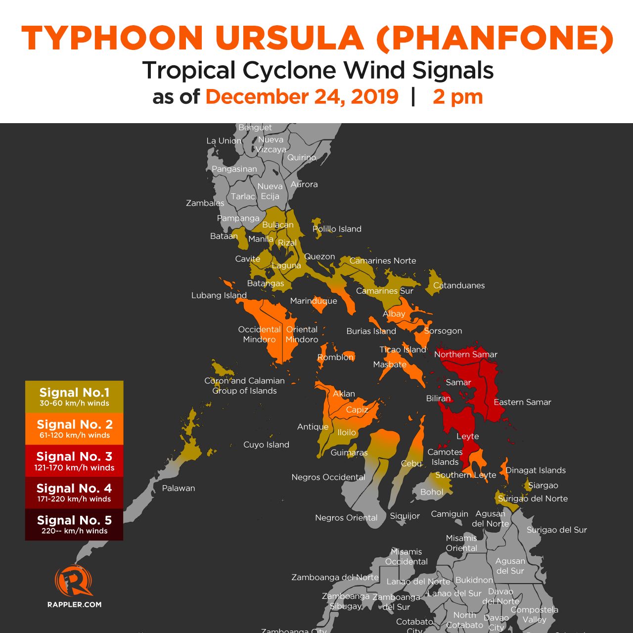
With Ursula becoming a typhoon, Signal No. 3 has also been raised for the first time. Below is the latest list of areas under tropical cyclone wind signals. (READ: Why is it now called tropical cyclone ‘wind’ – and not ‘warning’ – signals?)
Signal No. 3 (winds of 121 km/h to 170 km/h)
- Northern Samar
- Samar
- Eastern Samar
- Biliran
- Leyte
- Camotes Islands
Signal No. 2 (winds of 61 km/h to 120 km/h)
- southern part of Quezon (Mulanay, San Narciso, San Andres, San Francisco)
- Marinduque
- Oriental Mindoro
- Occidental Mindoro including Lubang Island
- Romblon
- Albay
- Sorsogon
- Masbate including Burias and Ticao Islands
- extreme northern part of Cebu including Bantayan and Camotes Islands (Bantayan, Madridejos, Santa Fe, Daanbantayan, Medellin, San Remigio, Bogo City, Tabogon, Tabuelan, Borbon, San Francisco, Poro, Tudela, Pilar)
- northeastern part of Iloilo (Carles, Balasan, Estancia, Batad, San Dionisio, Sara, Concepcion, Lemery, Ajuy)
- northern part of Antique (Libertad, Pandan, Sebaste, Culasi, Tibiao)
- Capiz
- Aklan
- Southern Leyte
- extreme northern part of Negros Occidental (Enrique B Magalona, Victorias, Manapla, Cadiz, Sagay, Escalante, Toboso)
- Dinagat Islands
Signal No. 1 (winds of 30 km/h to 60 km/h)
- Bulacan
- Bataan
- Metro Manila
- Rizal
- Cavite
- rest of Quezon
- Laguna
- Batangas
- Camarines Sur
- Camarines Norte
- Catanduanes
- northern Palawan (Linapacan, El Nido, Taytay, Araceli, Dumaran, San Vicente, Roxas)
- Calamian Islands
- Cuyo Islands
- rest of northern part of Cebu (Carmen, Asturias, Tuburan, Catmon, Sogod)
- central part of Cebu (Aloguinsan, Carcar City, Pinamungahan, San Fernando, Naga City, Toledo City, Minglanilla, Balamban, Talisay City, Cebu City, Cordova, Lapu-Lapu City, Mandaue City, Consolacion, Liloan, Compostela, Danao City)
- northeastern part of Bohol (Inabanga, Danao, Dagohoy, Pilar, Guindulman, Anda, Candijay, Alicia, Buenavista, Jetafe, Talibon, Trinidad, Bien Unido, San Miguel, Ubay, Mabini, President Carlos P Garcia)
- rest of Antique
- rest of Iloilo
- Guimaras
- northern part of Negros Occidental (Bacolod City, Bago City, Calatrava, La Carlota City, La Castellana, Moises Padilla, Binalbagan, Hinigaran, Isabela, Murcia, Pontevedra, Pulupandan, Salvador Benedicto, San Carlos City, San Enrique, Silay City, Talisay City, Valladolid)
- northern part of Negros Oriental (Canlaon City, Guihulngan City, Jimalalud, La Libertad, Vallehermoso)
- Surigao del Norte including Siargao and Bucas Grande Islands
PAGASA warned that areas under Signal No. 3 will begin to experience destructive typhoon-force winds on Tuesday afternoon, and “high-risk structures may experience heavy damage.”
Also on Tuesday afternoon, damaging gale- to storm-force winds will affect Southern Leyte. Similar winds will also hit Albay, Sorsogon, Masbate, Romblon, Aklan, Capiz, and portions of Antique, Iloilo, and the northern part of Cebu on Tuesday night; and Marinduque, the southern part of Quezon, and portions of Occidental Mindoro and Oriental Mindoro on Wednesday morning, December 25, Christmas Day.
“This may bring light to moderate damage to high-risk structures and at most light damage to medium-risk structures,” said PAGASA.
Moderate to strong winds, meanwhile, will begin affecting the northeastern part of Mindanao and Eastern Visayas on Tuesday; Bicol and parts of Central Visayas on Tuesday afternoon or evening; Calabarzon as well as parts of Mimaropa and Western Visayas on Wednesday morning; and Metro Manila, Bulacan, and Bataan on Wednesday morning or afternoon.
“Medium- to high-risk structures may experience light damage,” the state weather bureau said.
Rain from Ursula also persists, with more to come. PAGASA maintained this rainfall outlook:
Between Tuesday, December 24, and Wednesday noon, December 25
- Occasional to frequent heavy rain
- Dinagat Islands
- Siargao Island
- Bucas Grande Island
- Eastern Visayas
- Sorsogon
- Masbate
- northern and central parts of Cebu
- northern part of Negros Occidental
- northern part of Negros Oriental
- Aklan
- Antique
- Capiz
- Iloilo
- Guimaras
- Romblon
- Light to moderate rain with intermittent heavy rain
- rest of Bicol
- Quezon
- Marinduque
- Oriental Mindoro
- rest of the Visayas
- rest of Surigao del Norte
Between Wednesday noon and late evening, December 25
- Occasional to frequent heavy rain
- Aklan
- Antique
- Capiz
- Romblon
- Marinduque
- Oriental Mindoro
- Occidental Mindoro
- Batangas
- Calamian Islands
- Light to moderate rain with intermittent heavy rain
- Cuyo Islands
- Negros Occidental
- Negros Oriental
- Iloilo
- Guimaras
- Aurora
- rest of Calabarzon
Residents are advised to watch out for possible flash floods and landslides. (READ: FAST FACTS: Tropical cyclones, rainfall advisories)
There may also be storm surges up to 2 meters high in several coastal areas of these provinces:
- Eastern Samar
- Northern Samar
- Leyte
Travel remains risky in the eastern seaboards of the Philippines due to rough sea conditions. Seas will also be rough in the inland waters of Southern Luzon and the Visayas beginning Tuesday afternoon or evening, and in the western seaboards of Southern Luzon on Wednesday afternoon.
Maritime trips had been canceled as early as Monday, December 23. As of noon on Tuesday, the Philippine Coast Guard said it has recorded a total of 23,789 stranded passengers in Bicol, Central Visayas, Eastern Visayas, Southern Tagalog, Northern Mindanao, Western Visayas, and Southern Visayas.
There are canceled flights for Tuesday and Wednesday as well.
Based on its latest forecast track, Ursula is expected to leave the Philippine Area of Responsibility late Friday, December 27, or early Saturday, December 28.
Ursula is the Philippines’ 21st tropical cyclone for 2019, exceeding the yearly average of 20. (READ: LIST: PAGASA’s names for tropical cyclones in 2019)
Ursula is also the second tropical cyclone for December, after Typhoon Tisoy (Kammuri). PAGASA earlier said it was expecting one or two tropical cyclones during the month.
In December 2018, the Philippines had a deadly tropical cyclone during Christmas – Tropical Depression Usman. It left 156 people dead and 105 others injured in Eastern Visayas, Bicol, and Mimaropa, according to the National Disaster Risk Reduction and Management Council.
PAGASA declared the start of the rainy season last June 14. – Rappler.com
Add a comment
How does this make you feel?
There are no comments yet. Add your comment to start the conversation.