SUMMARY
This is AI generated summarization, which may have errors. For context, always refer to the full article.
What’s the weather like in your area? Tweet us at @rapplerdotcom.
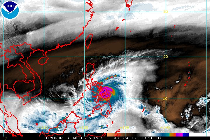
MANILA, Philippines – Typhoon Ursula (Phanfone) became even stronger early Tuesday evening, December 24, as it continued to batter Eastern Visayas with fierce winds and heavy rain.
In a bulletin issued 8 pm on Tuesday, the Philippine Atmospheric, Geophysical, and Astronomical Services Administration (PAGASA) said Ursula now has maximum winds of 130 kilometers per hour (km/h) from the previous 120 km/h and gustiness of up to 180 km/h from the previous 150 km/h.
The typhoon is already in the vicinity of Marabut, Samar. It earlier made landfall in Salcedo, Eastern Samar, at 4:45 pm on Tuesday, spoiling Christmas Eve for thousands in the Visayas.
Ursula slightly accelerated again, now moving west northwest at 30 km/h from the previous 25 km/h.
Its next stop is the Tacloban City-Palo area in Leyte. Leyte was the province hardest hit by Super Typhoon Yolanda (Haiyan) in November 2013.
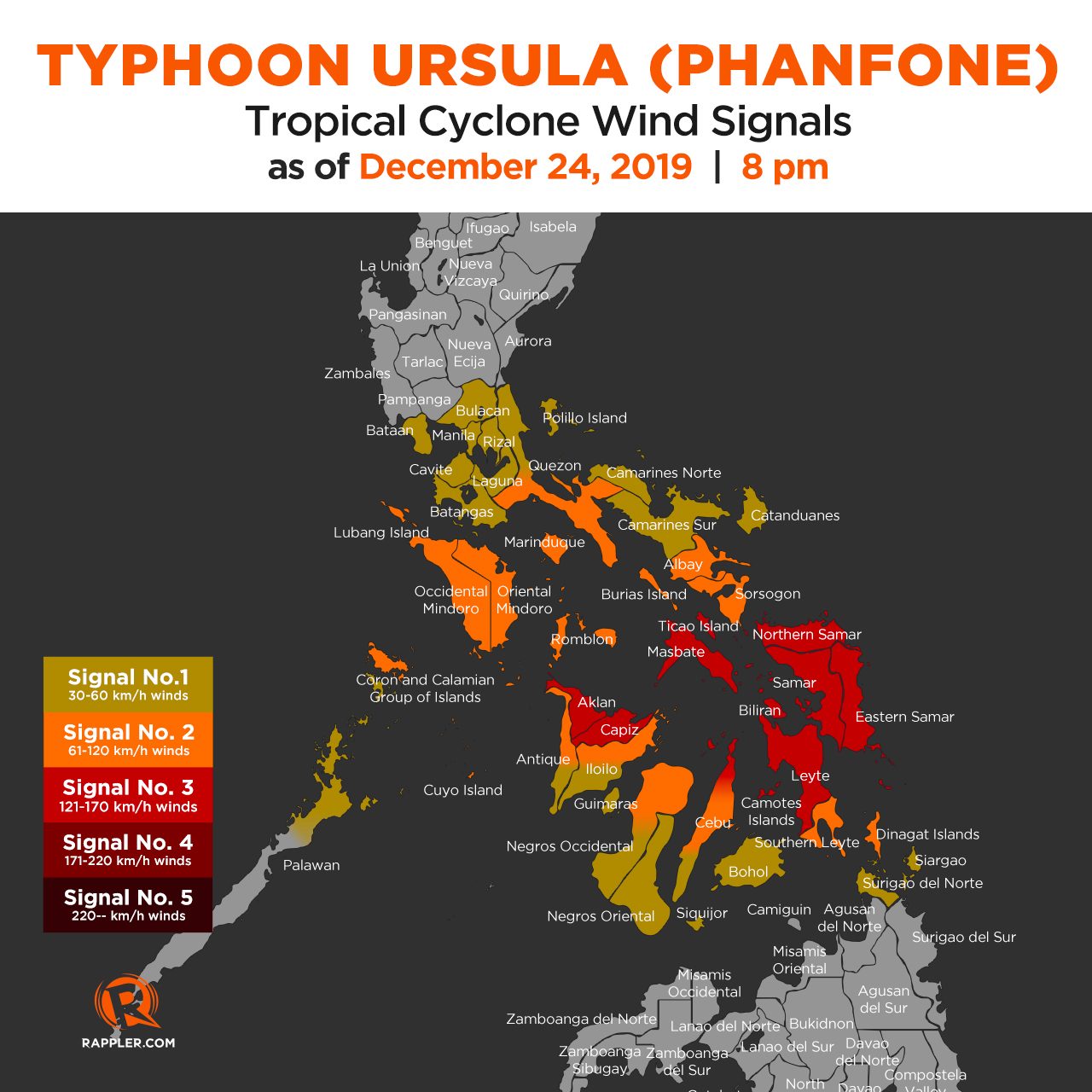
As of early Tuesday evening, Ursula’s eyewall was bringing violent winds to the southern parts of Eastern Samar and Samar, as well as the northern part of Leyte. Tropical cyclone wind signals remain raised. (READ: Why is it now called tropical cyclone ‘wind’ – and not ‘warning’ – signals?)
Signal No. 3 (winds of 121 km/h to 170 km/h)
- Masbate including Ticao Island
- Northern Samar
- Samar
- Eastern Samar
- Biliran
- Leyte
- extreme northern part of Cebu including Camotes Islands (Daanbantayan, Medellin, Bantayan, Sta Fe, Madridejos, San Francisco, Poro, Tudela, Pilar)
- Capiz
- Aklan
Signal No. 2 (winds of 61 km/h to 120 km/h)
- southern part of Quezon (Mulanay, San Narciso, San Andres, San Francisco)
- Marinduque
- Oriental Mindoro
- Occidental Mindoro including Lubang Island
- Romblon
- Albay
- Sorsogon
- Burias Island
- Calamian Islands
- Cuyo Islands
- central portion of the northern part of Cebu (Bogo City, Tabogon, Tabuelan, Borbon)
- northeastern part of Iloilo (Carles, Balasan, Estancia, Batad, San Dionisio, Sara, Concepcion, Lemery, Ajuy)
- northern part of Antique (Libertad, Pandan, Sebaste, Culasi, Tibiao)
- Southern Leyte
- northern part of Negros Occidental (Enrique B Magalona, Victorias, Manapla, Cadiz, Sagay, Escalante, Toboso)
- Dinagat Islands
Signal No. 1 (winds of 30 km/h to 60 km/h)
- Bulacan
- Bataan
- Metro Manila
- Rizal
- Cavite
- rest of Quezon
- Laguna
- Batangas
- Camarines Sur
- Camarines Norte
- Catanduanes
- northern part of Palawan (Linapacan, El Nido, Taytay, Araceli, Dumaran, San Vicente, Roxas)
- rest of Cebu
- Bohol
- Siquijor
- rest of Antique
- rest of Iloilo
- Guimaras
- Negros Oriental
- rest of Negros Occidental
- Surigao del Norte including Siargao and Bucas Grande Islands
PAGASA also gave this additional outlook for winds:
Tuesday evening, December 24
- destructive typhoon-force winds in Masbate including Ticao Island and portions of the northern part of Cebu
- damaging gale- to storm-force winds in Romblon, Aklan, Capiz, and portions of Antique, Iloilo, and the rest of northern Cebu
- moderate to strong winds in Bicol and parts of Central Visayas
Wednesday morning, December 25
- destructive typhoon-force winds in Capiz and Aklan
- damaging gale- to storm-force winds in Marinduque, the southern part of Quezon, Occidental Mindoro, Oriental Mindoro, and Calamian Islands
- moderate to strong winds in Calabarzon, and portions of Mimaropa and Western Visayas
Wednesday afternoon, December 25
- moderate to strong winds in Metro Manila, Bulacan, and Bataan
In terms of rainfall, this is PAGASA’s latest outlook:
Between Tuesday evening, December 24, and Wednesday noon, December 25
- Occasional to frequent heavy rain
- Dinagat Islands
- Siargao Island
- Bucas Grande Island
- Eastern Visayas
- Sorsogon
- Masbate
- northern and central parts of Cebu
- northern part of Negros Occidental
- northern part of Negros Oriental
- Aklan
- Antique
- Capiz
- Iloilo
- Guimaras
- Romblon
- Light to moderate rain with intermittent heavy rain
- rest of Bicol
- Quezon
- Marinduque
- Oriental Mindoro
- rest of the Visayas
- rest of Surigao del Norte
Between Wednesday noon and late evening, December 25
- Occasional to frequent heavy rain
- Aklan
- Antique
- Capiz
- Romblon
- Marinduque
- Oriental Mindoro
- Occidental Mindoro
- Calamian Islands
- Light to moderate rain with intermittent heavy rain
- Cuyo Islands
- Negros Occidental
- Negros Oriental
- Iloilo
- Guimaras
- Aurora
- Calabarzon
There could be flash floods, especially in low-lying communities, and landslides in mountainous areas. (READ: FAST FACTS: Tropical cyclones, rainfall advisories)
There may also be storm surges up to 2 meters high in several coastal areas of these provinces:
- Eastern Samar
- Northern Samar
- Leyte
Travel remains risky in the eastern seaboards of the Philippines due to rough sea conditions. Seas will also be rough in the inland waters of Southern Luzon and the Visayas on Tuesday evening, and in the western seaboards of Southern Luzon on Wednesday afternoon.
The Philippine Coast Guard said there have been at least 23,789 stranded passengers in Bicol, Central Visayas, Eastern Visayas, Southern Tagalog, Northern Mindanao, Western Visayas, and Southern Visayas.
There are canceled flights for Tuesday and Wednesday as well.
Based on its latest forecast track, Ursula is expected to leave the Philippine Area of Responsibility on Friday, December 27.

Ursula is the Philippines’ 21st tropical cyclone for 2019, exceeding the yearly average of 20. (READ: LIST: PAGASA’s names for tropical cyclones in 2019)
Ursula is also the second tropical cyclone for December, after Typhoon Tisoy (Kammuri). PAGASA earlier said it was expecting one or two tropical cyclones during the month.
In December 2018, the Philippines had a deadly tropical cyclone during Christmas – Tropical Depression Usman. It left 156 people dead and 105 others injured in Eastern Visayas, Bicol, and Mimaropa, according to the National Disaster Risk Reduction and Management Council.
PAGASA declared the start of the rainy season last June 14. – Rappler.com
Add a comment
How does this make you feel?
There are no comments yet. Add your comment to start the conversation.