SUMMARY
This is AI generated summarization, which may have errors. For context, always refer to the full article.
What’s the weather like in your area? Tweet us at @rapplerdotcom.
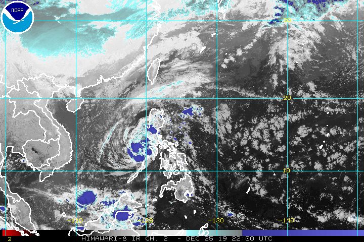
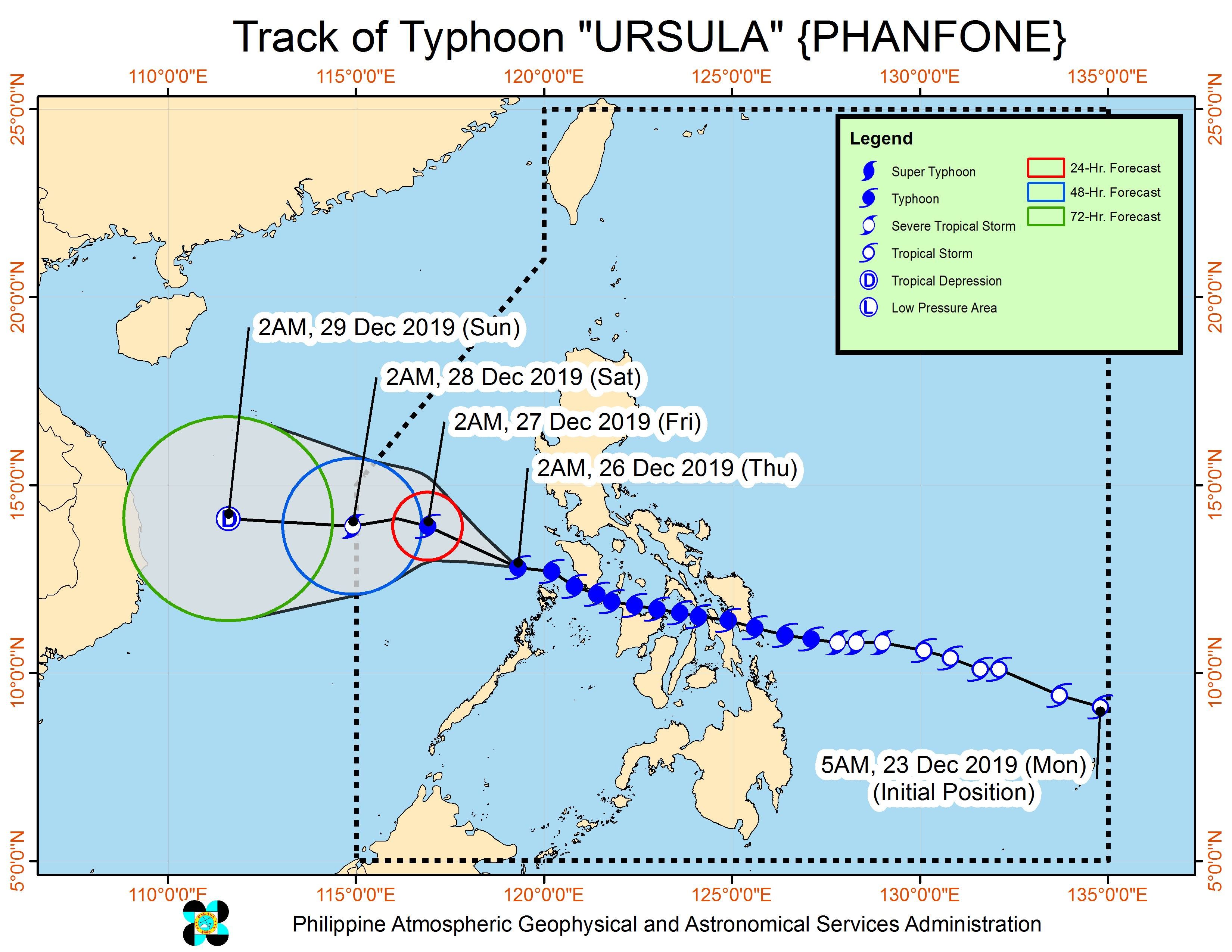
MANILA, Philippines – After making 7 landfalls in the country, Typhoon Ursula (Phanfone) is now over the West Philippine Sea.
In a briefing past 5 am on Thursday, December 26, the Philippine Atmospheric, Geophysical, and Astronomical Services Administration (PAGASA) said Ursula is already 155 kilometers northwest of Coron, Palawan.
The typhoon slightly slowed down, now moving west northwest at 15 kilometers per hour (km/h) from the previous 20 km/h.
It continues to have maximum winds of 130 km/h and gustiness of up to 160 km/h.
Ursula’s first 3 landfalls were in Eastern Visayas on Christmas Eve, the next 3 in Western Visayas on Christmas Day, and the 7th in Oriental Mindoro, also on Christmas Day.
Tuesday, December 24
- Salcedo, Eastern Samar – 4:45 pm
- Tacloban City, Leyte – 7:30 pm
- Cabucgayan, Biliran – 9:15 pm
Wednesday, December 25
- Gigantes Islands, Carles, Iloilo – 2:30 am
- Ibajay, Aklan – 8:40 am
- Semirara Island, Caluya, Antique – 1 pm
- Bulalacao, Oriental Mindoro – 3 pm
Some areas in Ursula’s path experienced heavy flooding and serious damage.
Few areas remain under tropical cyclone wind signals as of dawn on Thursday. (READ: Why is it now called tropical cyclone ‘wind’ – and not ‘warning’ – signals?)
Signal No. 2 (winds of 61 km/h to 120 km/h)
- Calamian Islands (Coron, Culion, Busuanga)
Signal No. 1 (winds of 30 km/h to 60 km/h)
- Bataan
- Cavite
- Batangas
- Oriental Mindoro
- Occidental Mindoro including Lubang Island
- rest of the extreme northern part of Palawan (Linapacan, El Nido)
Though Ursula is already over the West Philippine Sea, there will still be rain in parts of Luzon on Thursday. But PAGASA Weather Specialist Raymond Ordinario said weather will gradually improve later as Ursula moves farther from land. (READ: FAST FACTS: Tropical cyclones, rainfall advisories)
Occasional to frequent heavy rain
- Calamian Islands
- Occidental Mindoro including Lubang Island
Light to moderate rain with intermittent heavy rain
- Oriental Mindoro
- rest of the extreme northern part of Palawan
- Calabarzon
- Metro Manila
- Central Luzon
PAGASA advised residents of those areas to stay on alert for flash floods and landslides.
There are no more storm surge advisories, but travel remains risky in the seaboards of areas under tropical cyclone wind signals. Ursula earlier left at least 23,789 passengers stranded.
Dozens of domestic flights have been canceled since Christmas Eve onwards.
Based on its latest forecast track, Ursula is expected to leave the Philippine Area of Responsibility on Saturday morning, December 28.
Ursula is the Philippines’ 21st tropical cyclone for 2019, exceeding the yearly average of 20. (READ: LIST: PAGASA’s names for tropical cyclones in 2019)
Ursula is also the second tropical cyclone for December, after Typhoon Tisoy (Kammuri). PAGASA earlier said it was expecting one or two tropical cyclones during the month.
In December 2018, the Philippines had a deadly tropical cyclone during Christmas – Tropical Depression Usman. It left 156 people dead and 105 others injured in Eastern Visayas, Bicol, and Mimaropa, according to the National Disaster Risk Reduction and Management Council.
PAGASA declared the start of the rainy season last June 14. – Rappler.com
Add a comment
How does this make you feel?
There are no comments yet. Add your comment to start the conversation.