SUMMARY
This is AI generated summarization, which may have errors. For context, always refer to the full article.

What’s the weather like in your area? Tweet us at @rapplerdotcom.
MANILA, Philippines – Severe Tropical Storm Ambo (Vongfong) started moving toward the province of Bulacan early Friday evening, May 15, after making landfall for the 7th time in the country.
In a bulletin issued 8 pm on Friday, the Philippine Atmospheric, Geophysical, and Astronomical Services Administration (PAGASA) said Ambo made its 7th landfall in Real, Quezon, at 5 pm.
As of 7 pm, it was already in the vicinity of General Nakar, Quezon, still moving northwest at 20 kilometers per hour (km/h). While still in Quezon, Ambo was already making its presence felt in Metro Manila, as the capital region started experiencing fierce winds and heavy rain.
Ambo’s first 6 landfalls were as a typhoon, while its 7th was as a severe tropical storm. Despite the earlier downgrade, it remains a strong tropical cyclone, battering areas in its path. It made landfall in the following areas:
Thursday, May 14
- San Policarpo, Eastern Samar – 12:15 pm
- Dalupiri Island, Northern Samar – 10:15 pm
- Capul Island, Northern Samar – 10:30 pm
Friday, May 15
- Ticao Island, Masbate – 12 am
- Burias Island, Masbate – 3 am
- San Andres, Quezon – 7:45 am
- Real, Quezon – 5 pm
As of early Friday evening, Ambo has maximum winds of 100 km/h and gustiness of up to 165 km/h. (READ: FAST FACTS: Tropical cyclones, rainfall advisories)
Many areas in Luzon remain under tropical cyclone wind signals. (READ: Why is it now called tropical cyclone ‘wind’ – and not ‘warning’ – signals?)
Signal No. 2 (winds of 61 to 120 km/h, or strong to damaging gale-/storm-force winds during the passage of the severe tropical storm)
- Ilocos Norte
- Ilocos Sur
- Apayao
- Abra
- Kalinga
- Mountain Province
- Ifugao
- Benguet
- La Union
- Nueva Vizcaya
- Nueva Ecija
- Quirino
- Aurora
- eastern part of Pangasinan (San Nicolas, Natividad, San Quintin, Umingan, Balungao, Sta Maria, Tayug, Asingan, San Manuel, Binalonan, Laoac, Urdaneta, Villasis, Rosales, Sto Tomas, Alcala, Bautista, Bayambang, Urbiztondo, Basista, Malasiqui, Sta Barbara, Manaoag, Mapandan, San Jacinto, San Fabian, Pozorrubio, Sison, Mangaldan, Dagupan, Calasiao, Binmaley, Lingayen, Bugallon, Aguilar, San Carlos, Mangatarem)
- Tarlac
- Pampanga
- Bulacan
- Metro Manila
- Cavite
- Laguna
- Rizal
- northern and central parts of Quezon (General Nakar, Infanta, Real, Mauban, Sampaloc. Lucban, Tayabas, Sariaya, Candelaria, Dolores, Tiaong, San Antonio, Lucena, Pagbilao, Atimonan, Padre Burgos, Agdangan, Plaridel, Unisan, Gumaca, Pitogo, Macalelon, General Luna, Catanauan, Lopez, Buenavista, Guinayangan, Calauag, Tagkayawan, Perez, Alabat, Quezon)
- Polillo Island
- southern and western parts of Isabela (Quezon, Mallig, Roxas, Quirino, San Manuel, Burgos, Gamu, Reina Mercedes, Aurora, Luna Cabatuan, Naguilian, Benito Soliven, Cauayan, San Guillermo, Dinapigue, San Mateo, Alicia, Angadanan, Ramon, San Isidro, Echague, Jones, San Agustin, Santiago, Cordon)
Signal No. 1 (winds of 30 to 60 km/h, or strong to near-gale-force winds during the passage of the severe tropical storm)
- Cagayan including Babuyan Islands
- Batanes
- Zambales
- Bataan
- rest of Isabela
- Batangas
- Marinduque
- rest of Quezon
- Camarines Norte
- northwestern part of Camarines Sur (Del Gallego, Ragay, Lupi, Sipocot)
PAGASA warned that aside from damaging winds, rain from Ambo will persist. Below are the affected areas.
Friday evening, May 15
Moderate to heavy rain, with at times intense rain
- Metro Manila
- Calabarzon
- Aurora
- Bulacan
- Pampanga
- Nueva Ecija
- Isabela
- Nueva Vizcaya
- Quirino
- Occidental Mindoro
- Marinduque
Between Friday evening, May 15, and Saturday evening, May 16
Moderate to heavy rain, with at times intense rain
- Cordillera Administrative Region
- Ilocos Region
- Central Luzon
- Nueva Vizcaya
- Quirino
PAGASA advised the public to stay on alert for possible floods and landslides. Tens of thousands of people earlier fled their homes as authorities enforced preemptive evacuation. (READ: Social distancing ‘per family’ at Typhoon Ambo evacuation centers)
Sea travel remains risky for all vessels in the seaboards of areas under tropical cyclone wind signals.
Ambo is expected to leave the Philippine Area of Responsibility on Monday, May 18. By then, it is likely to have weakened already into a tropical depression.
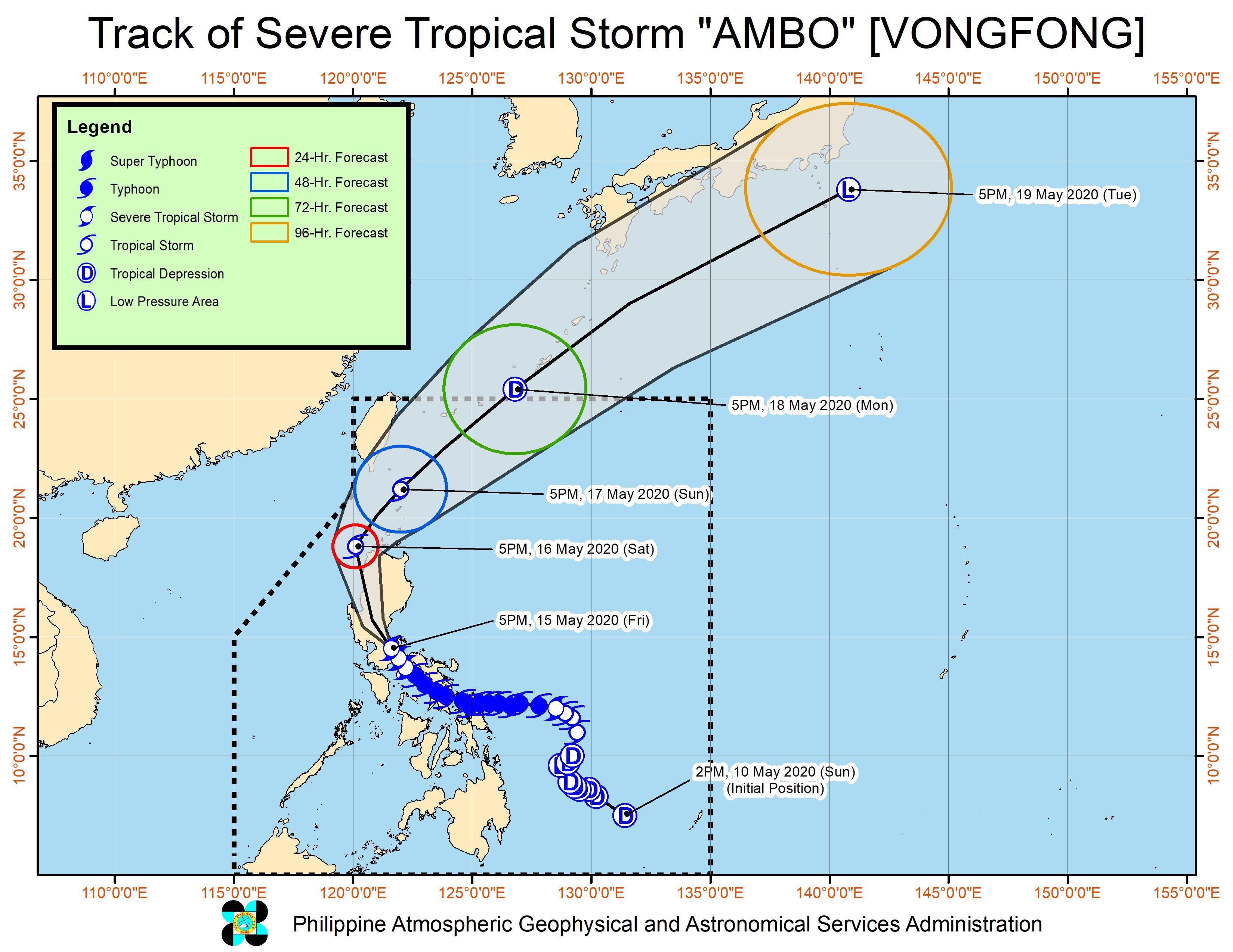
Ambo is the Philippines’ first tropical cyclone for 2020. The country gets an average of 20 tropical cyclones per year. (READ: LIST: PAGASA’s names for tropical cyclones in 2020)
In PAGASA’s climate outlook, it gave the following estimates for the number of tropical cyclones in the next 6 months:
- May – 1 or 2
- June – 1 or 2
- July – 2 to 4
- August – 2 or 3
- September – 2 or 3
- October – 2 or 3
– Rappler.com
Add a comment
How does this make you feel?
There are no comments yet. Add your comment to start the conversation.