SUMMARY
This is AI generated summarization, which may have errors. For context, always refer to the full article.

What’s the weather like in your area? Tweet us at @rapplerdotcom.
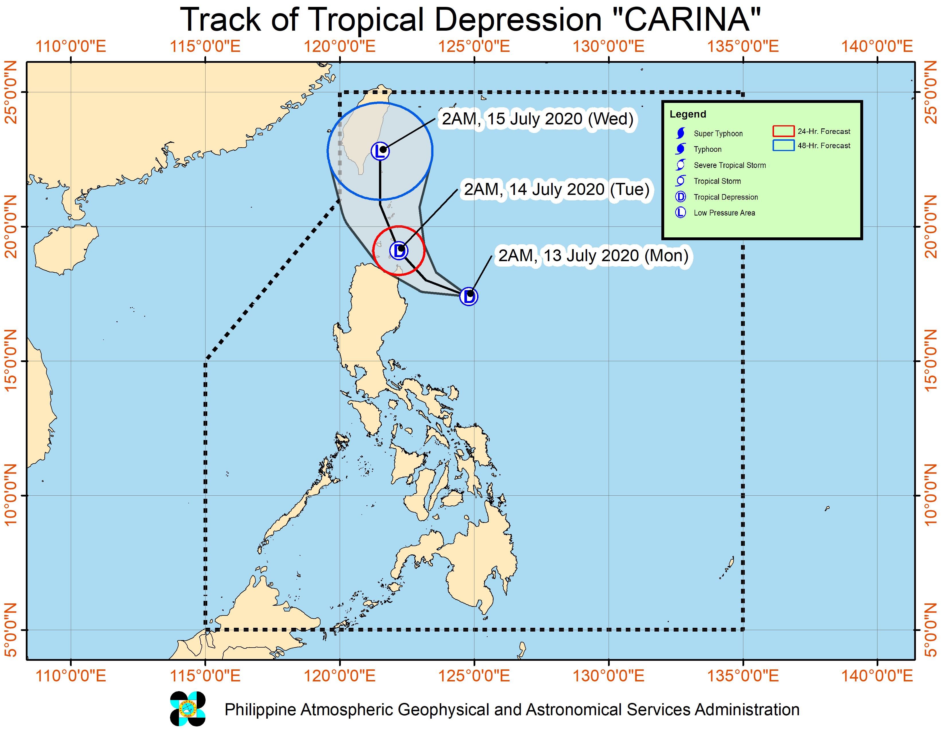
MANILA, Philippines – The low pressure area (LPA) east of Cagayan province developed into a tropical depression at 2 am on Monday, July 13. It was given the local name Carina.
Tropical Depression Carina is the Philippines’ 3rd tropical cyclone for 2020, after Typhoon Ambo (Vongfong) in May and Tropical Storm Butchoy (Nuri) in June.
The Philippine Atmospheric, Geophysical, and Astronomical Services Administration (PAGASA) said in a bulletin at 5 am on Monday that Carina is already 315 kilometers east of Tuguegarao City, Cagayan. It is moving west at 20 kilometers per hour (km/h).
The tropical depression has maximum winds of 45 km/h and gustiness of up to 55 km/h. (READ: FAST FACTS: Tropical cyclones, rainfall advisories)
Signal No. 1 is raised over the following areas:
- Batanes
- Babuyan Islands
- northeastern part of mainland Cagayan (Santa Ana, Gonzaga, Santa Teresita, Buguey, eastern part of Lal-lo, eastern part of Gattaran, eastern part of Baggao)
PAGASA said areas under Signal No. 1 “may experience occasional gusts” due to Carina. (READ: Why is it now called tropical cyclone ‘wind’ – and not ‘warning’ – signals?)
The state weather bureau also provided the following rainfall outlook for Monday:
Moderate to heavy rain
- Babuyan Islands
- eastern part of mainland Cagayan
- eastern part of Isabela
Light to moderate rain with at times heavy rain
- Ilocos Region
- Cordillera Administrative Region
- rest of Cagayan Valley
- Aurora
- northern part of Quezon including Polillo Island
PAGASA also warned that moderate to rough seas, with waves 1.2 to 3.1 meters high, will be experienced in the northern and eastern seaboards of Luzon in the next 24 hours. Small vessels are advised not to set sail.
Based on Carina’s latest forecast track, PAGASA said it could just pass close to the northeastern part of Cagayan and the Babuyan Islands between Monday night and Tuesday morning, July 14.
“However, accounting for the forecast track probability cone, a landfall scenario over these areas remains likely,” added the state weather bureau.
An average of 20 tropical cyclones form within or enter the Philippine Area of Responsibility (PAR) each year. Only around half of these make landfall. (READ: LIST: PAGASA’s names for tropical cyclones in 2020)
In PAGASA’s climate outlook, it gave the following estimates for the number of tropical cyclones inside PAR in the next 6 months:
- July – 2 to 4
- August – 2 or 3
- September – 2 or 3
- October – 2 or 3
- November – 1 or 2
- December – 1 or 2
PAGASA declared the start of the rainy season on June 12. – Rappler.com
Add a comment
How does this make you feel?
There are no comments yet. Add your comment to start the conversation.