SUMMARY
This is AI generated summarization, which may have errors. For context, always refer to the full article.

What’s the weather like in your area? Tweet us at @rapplerdotcom.
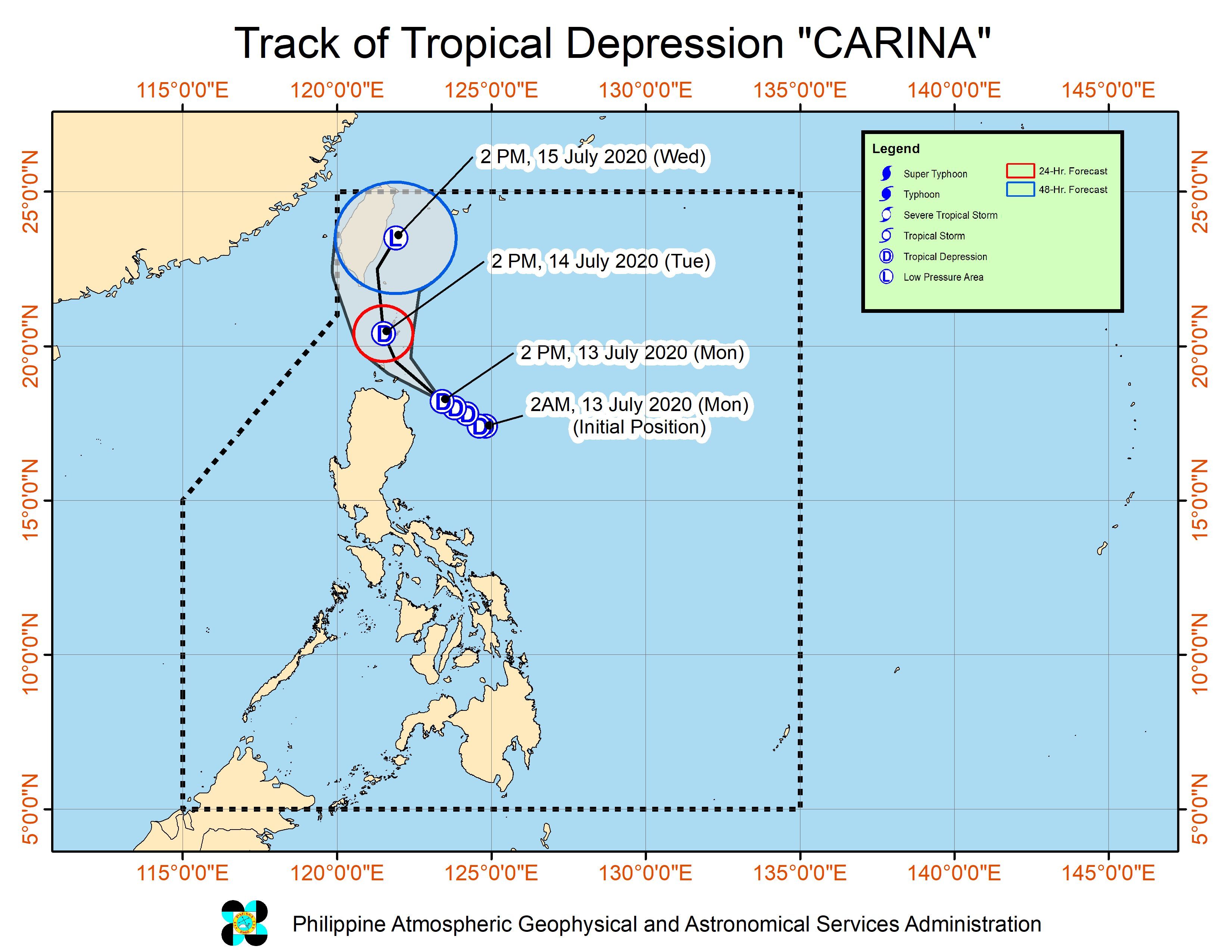
MANILA, Philippines – Tropical Depression Carina maintained its strength on Monday afternoon, July 13, as it headed for the Luzon Strait, which is located near the Batanes-Cagayan area.
In an online briefing past 5 pm on Monday, the Philippine Atmospheric, Geophysical, and Astronomical Services Administration (PAGASA) said Carina is now 165 kilometers east of Aparri, Cagayan.
The tropical depression is moving west northwest at the same speed of 15 kilometers per hour (km/h).
It could just pass through the Luzon Strait, roughly 100 kilometers off the northeastern tip of Luzon and near the Babuyan Islands and Batanes. But there is still a chance it might hit land.
“Accounting for the forecast track probability cone, a landfall scenario over these areas remains a possibility,” PAGASA said.
At the moment, Carina continues to have maximum winds of 45 km/h and gustiness of up to 55 km/h. It is not forecast to become a tropical storm and might weaken back into a low pressure area on Wednesday, July 15. (READ: FAST FACTS: Tropical cyclones, rainfall advisories)
As Carina neared, more parts of mainland Cagayan were placed under Signal No. 1 on Monday afternoon. This is the latest list of areas covered:
- Batanes
- Babuyan Islands
- northeastern part of mainland Cagayan (Santa Ana, Gonzaga, Santa Teresita, Buguey, Camalaniugan, Aparri, Lal-lo, Gattaran, Baggao)
PAGASA said areas under Signal No. 1 “may experience occasional gusts.” (READ: Why is it now called tropical cyclone ‘wind’ – and not ‘warning’ – signals?)
Rainfall from Carina will continue in parts of Luzon as well. PAGASA reminded the public that there could be floods and landslides.
Scattered to widespread moderate to heavy rain
- Cagayan including Babuyan Islands
- Isabela
- Apayao
- Abra
- Kalinga
- Ilocos Norte
Scattered light to moderate rain with at times heavy rain
- Central Luzon
- rest of Northern Luzon
Moderate to rough sea conditions will also persist in the northern and eastern seaboards of Luzon in the next 24 hours. Waves could reach 1.2 to 3.1 meters high, which may be risky for small vessels.
Carina is the Philippines’ 3rd tropical cyclone for 2020, after Typhoon Ambo (Vongfong) in May and Tropical Storm Butchoy (Nuri) in June.
An average of 20 tropical cyclones form within or enter the Philippine Area of Responsibility (PAR) each year. Only around half of these make landfall. (READ: LIST: PAGASA’s names for tropical cyclones in 2020)
In PAGASA’s climate outlook, it gave the following estimates for the number of tropical cyclones inside PAR in the next 6 months:
- July – 2 to 4
- August – 2 or 3
- September – 2 or 3
- October – 2 or 3
- November – 1 or 2
- December – 1 or 2
PAGASA declared the start of the rainy season on June 12. – Rappler.com
Add a comment
How does this make you feel?
There are no comments yet. Add your comment to start the conversation.