SUMMARY
This is AI generated summarization, which may have errors. For context, always refer to the full article.

MANILA, Philippines (UPDATE) – Tropical storm Gorio (international codename Rumbia) continues to bring rain over large parts of Luzon early Sunday, June 30, and has maintained its strength overnight.
Gorio was spotted 120 km west of Ambulong, Batangas (14.1°N, 119.9°E) as of 8 am Sunday, June 30, carrying maximum sustained winds of 65 kilometers per hour (km/h) and gusts of up to 80 km/h.
The storm is estimated to carry moderate to heavy rainfall (5-15 mm/h) within its 300 km diameter, state weather bureau PAGASA said in its 5 am severe weather bullentin for Gorio.
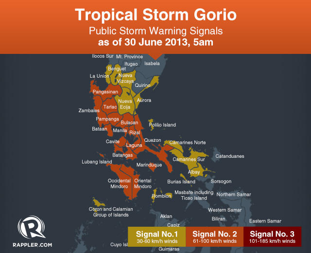
Public storm warning signal #2 has been raised over:
- Pangasinan
- Tarlac
- Zambales
- Pampanga
- Bulacan
- Rizal
- Metro Manila
- Bataan
- Cavite
- Laguna
- Batangas
- Quezon
- Marinduque
- Oriental Mindoro
- Occidental Mindoro
These areas can expect moderate damage to agriculture, particularly to rice and corn; moderate damage to light structures; and travel by all types of sea vessels and aircraft will be risky.
Storm signal #1 is in effect over:
- La Union
- Benguet
- Nueva Ecija
- Nueva Vizcaya
- Polilio Island
- Southern Aurora
- Camarines Norte
- Camarines Sur
- Albay
- Burias Island
- Romblon
- Coron Island
- Calamian Group of Islands
Sea travel by small seacraft and fishing boats will be risky in these areas, the bureau said.
Public storm signals elsewhere have been lowered, PAGASA said.
Areas under the public storm warning signals are warned against possible flash floods and landslides, while those near the coasts should be on the lookout for possible storm surges.
Gorio is moving west northwest at a speed of 26 km/h, and is estimated to be 500 km northwest of Subic, Zambales and out of the Philippine Area of Responsibility (PAR) by Monday morning. – Rappler.com
Add a comment
How does this make you feel?
There are no comments yet. Add your comment to start the conversation.