SUMMARY
This is AI generated summarization, which may have errors. For context, always refer to the full article.
What’s the weather like in your area? Tweet us the situation: Use #weatheralert and tag@rapplerdotcom.
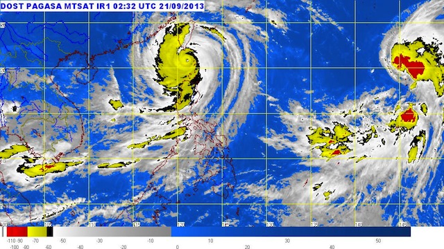
MANILA, Philippines (6th UPDATE) – Typhoon Odette (international codename Usagi) has weakened a bit after hitting Batanes early Saturday, September 21, state weather bureau PAGASA said.
As of 10 am, Odette was 60 kilometers west of Itbayat, Batanes, carrying maximum sustained winds of 185 km/h near the center and gusts of up to 220 km/h.
Storm warning signal number 3 is currently hoisted over Batanes.
“This is the strongest typhoon to hit the province since 1987,” Batanes Rep Dina Abad told Rappler in a text message.
Abad told Rappler: “Strong winds and rain came at around 10 am (Friday, September 20) until this morning. The electric coop’s distribution system has been damaged. Houses made of light materials destroyed. May mga punong bumagsak, mga pananim na nasira.” (Trees fell down, crops destroyed.)
“Kahit humina na ang ulan at hangin – wala pa ring lumalabas sa bahay,” Abad added. (Even as the winds die down, people are not leaving their homes.)
“The winds are very strong. I cannot even go out now,” Batanes Governor Vicente Gato told dzBB radio in Manila. “Many trees have been uprooted and we have no electricity,” he said.
Signal number 2 is in effect over the following areas:
- Cagayan
- Apayao
- Ilocos Norte
Signal number 1 is in effect over these provinces
- Abra
- Kalinga
- Isabela
- Benguet
- La Union
- Ilocos Sur
- Mountain Province
- Ifugao
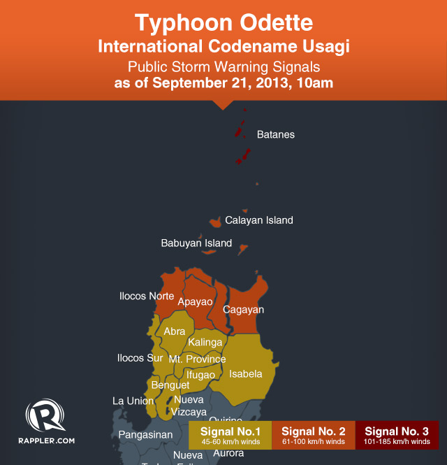
Public storm warning signals in other areas have been lowered.
Heavy to intense rainfall is expected within the typhoon’s 800 km diameter, and residents of areas with public storm warning signals should be on alert for flash floods, landslides, and storm surges.
The typhoon is expected to be out of the Philippine Area of Responsibility (PAR) by Saturday afternoon.
Landfall over Batanes
Odette intensified dramatically into a “super typhoon” in the early hours Friday, September 20.
The typhoon was packing maximum sustained winds of 215 kph near the center and gusting up to 250 kph as it made landfall over the municipality of Itbayat, Batanes (20.7°N, 121.9°E) at around 7 am Saturday.
The US Navy’s Joint Typhoon Warning Center (JTWC) has labeled Odette (Usagi) as a super typhoon. Based on their data, Odette was packing sustained winds of 240 km/h (150 mi/h) with gusts of nearly 300 km/h, making it the equivalent of a strong Category 4 Atlantic hurricane.
The Philippine weather bureau has no official “super typhoon” category, but raises the storm warning signal number 4 for typhoons carrying maximum sustained winds of more than 186 km/h.
PAGASA last raised storm signal number 4 back in August 2011, during Typhoon Mina (Nanmadol).
The National Disaster Risk Reduction and Management Council (NDRRMC) issued its highest alert, with flooding recorded in four regions in Luzon, while several roads and bridges were rendered impassable by overflowing rivers or landslides.
There were no immediate reports of any casualties, although emergency and relief services said they were prepared for the worst with more than 100 families having already been evacuated in one northern province.
Emergency relief services were also put on heightened alert, with the Red Cross already stockpiling first aid kits and food packs in some areas.
“Damage to affected communities can be very heavy,” the PAGASA said. “The situation is potentially very destructive to communities. All travel and outdoor activities should be cancelled.”
South China on target
The system roared through the Luzon Strait dividing the Philippines and Taiwan on Saturday morning as it barrels towards Hong Kong and the Chinese coast.
Taiwan’s southern tip is set to be clipped by the storm’s northeast quadrant, typically home to a tropical cyclone’s most powerful winds.
“It is the strongest typhoon in the west Pacific region this year,” a weather forecaster at the Taiwan Central Weather Bureau told Agence France-Presse on Friday. Meteorologists have described the typhoon as the most powerful tropical cyclone to form in 2013 so far.
In Taiwan, some flights were cancelled and ferry services suspended, with schools and offices in many parts of the island closed, especially in the south and east, which were expected to bear the brunt of the storm, authorities said.
Hotels and resorts in mountainous areas were closed due to fears of flooding and landslides.
Coastguards cordoned off the beaches at Kenting, a popular scenic spot in the south, as strong winds whipped up the sea.
The defense ministry has deployed more than 1,600 soldiers to “high risk” areas and placed 24,000 others on standby.
Nearly 2,500 people had already been evacuated, officials said, as the Central Weather Bureau warned people to expect up to 1.2 meters (47 inches) of rain.
Preparations in China, Hong Kong
In Hong Kong, officials warned the storm posed a “severe threat” to the city, urging residents to brace for strong winds and possible flooding, while Cathay Pacific said it may have to cancel flights.
“The weather will deteriorate significantly with high winds and rough seas,” the city’s observatory said.
China’s National Meteorological Center issued a red alert – its highest level warning – as it forecast gale-force winds and heavy rain.
It said Usagi would affect the coastal areas of the provinces of Guangdong, Zhejiang and Fujian as it moved northwest.
Nearly 23,000 fishing boats had earlier taken shelter in Fujian province ahead of the storm, state media reported Saturday, while more than 4,000 people living in coastal areas were evacuated.
In China, nearly 23,000 fishing boats took shelter in Fujian province ahead of the storm, state media reported early Saturday, while more than 4,000 people living in coastal fish farms were evacuated.
Saturday PH weather
Odette will continue to enhance the southwest monsoon that will bring moderate to occasionally heavy rains and thunderstorms over the western section of Southern Luzon.
Meanwhile, Metro Manila, the rest of Luzon and Western Visayas will have cloudy skies with light to moderate rainshowers and thunderstorms.
Mindanao and the rest of Visayas will experience partly cloudy to cloudy with isolated rainshowers or thunderstorms.
PAGASA will next issue a bulletin on Odette at 5 pm today. – With reports from Agence France-Presse/Rappler.com
Add a comment
How does this make you feel?
There are no comments yet. Add your comment to start the conversation.