SUMMARY
This is AI generated summarization, which may have errors. For context, always refer to the full article.
What’s the weather like in your area? Tweet us the situation: Use #weatheralert and tag @rapplerdotcom.

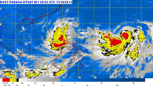
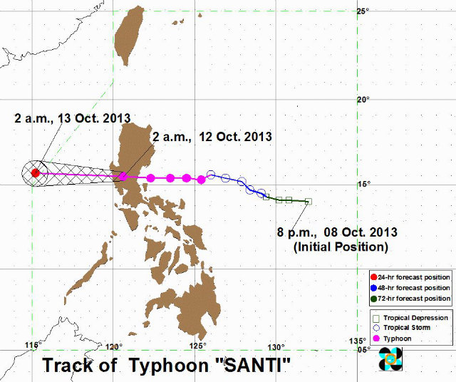
MANILA, Philippines (UPDATED) – Typhoon Santi (international name: Nari) weakened as it made landfall, crossing central Luzon and making its way to the West Philippine sea (South China sea).
As of 4:00 am Saturday, October 12, Santi was in the vicinity of Iba, Zambales (15.4°N, 120.0°E), according to a bulletin issued by state weather bureau PAGASA.
As of an 8:00 am update by PAGASA, the following areas received a yellow rainfall advisory which indicates 7.5 to 15 millimeter (heavy) rain has fallen in the last hour and will likely fall for the next to hours. lt also warns of possible flooding.
- Metro Manila
- Rizal
- Laguna
- Cavite
- Batangas
- Northern Quezon
- Bulacan
- Pampanga
- Tarlac
- Bataan
- Zambales
Public storm warning signals in several areas were lowered since PAGASA’s last bulletin, issued 6 hours earlier, as Santi first made landfall.
Storm warning signal no. 3 remains hoisted over 2 areas while 3 areas remain under signal no. 2. 14 areas including Metro Manila are under storm signal no. 1.
Storm warning signal number 3 (winds of 101-185 km/h in the next 18 hours)
- Zambales
- Pangasinan
Storm warning signal number 2 (2inds of 61-100 km/h expected in the next 24 hours)
- La Union
- Benguet
- Tarlac
- Pampanga
- Bataan
Storm warning signal number 1 (winds of 30-60 km/h expected in the next 36 hours)
- Ilocos Sur
- Mt. Province
- Ifugao
- Nueva Viscaya
- Quirino
- Aurora
- Nueva Ecija
- Bulacan
- Metro Manila
- Rizal
- Cavite
- Laguna
- Batangas
- Lubang Islands

The storm is expected to bring heavy to intense rainfall (7.5-25.0 mm/hour) within its 400 km diameter.
Santi packs maximum sustained winds of 120 kilometers/hour near the center with gustiness of up to 150 km/h as it is forecast to move west at 22 km/h.
Those living in low lying and mountainous areas along the typhoon’s path should stay on alert for flash floods and landslides. Likewise, those living in coaster areas under storm signals 3 and 2 should be on the lookout for storm surges of up to 4 meters.
Sea travel along the Luzon and Visayas seaboards is considered risky.
By Sunday morning, October 13, Santi is expected to be 470 west of Iba, Zambales, or outside the Philippine Area of Responsibility.
The next bulletin on Santi will be issued at 11 am Saturday, October 12. – Rappler.com
Help report and map incidents of flooding and rescue using Rappler’s crowdsourcing tool.
Use hashtag #FloodPH for flood alerts and tag @moveph. Indicate street, town/city and province.
Use hashtag #RescuePH for rescue calls and tag @moveph. Add your name, exact location, and your contact details.
Add a comment
How does this make you feel?
There are no comments yet. Add your comment to start the conversation.