SUMMARY
This is AI generated summarization, which may have errors. For context, always refer to the full article.
 November 5, 2013. Image courtesy NOAA")
MANILA, Philippines – The Philippines should brace for a new storm that will enter the Philippine Area of Responsibility (PAR) later this week.
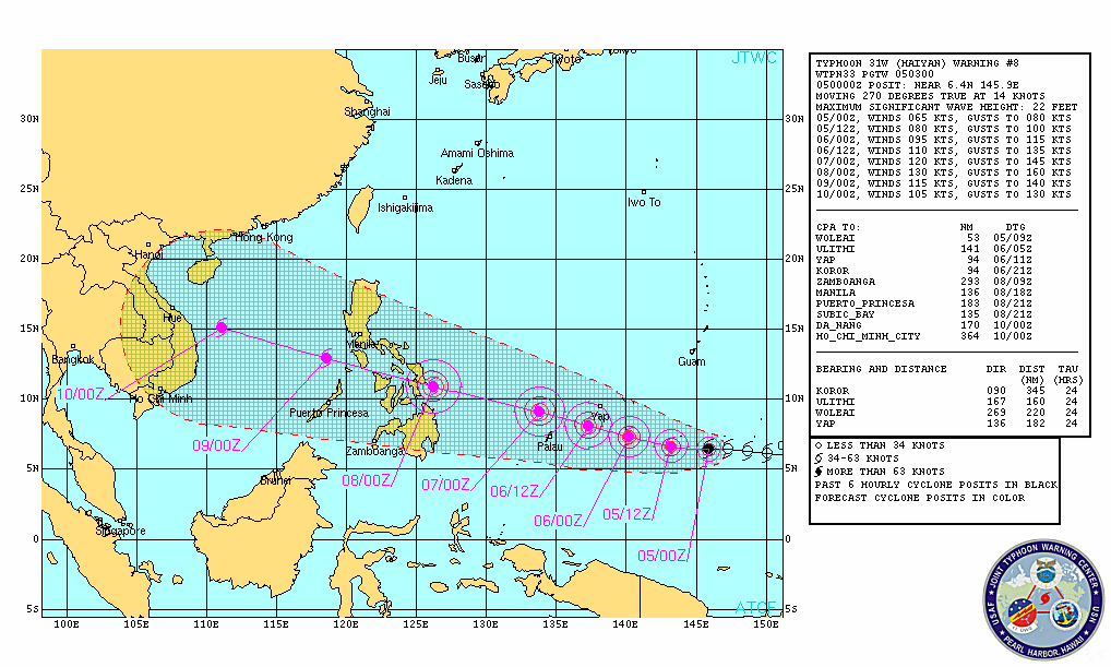
Tropical Storm Haiyan was located 2,170 kilometers east of Mindanao, or in the vicinity of the Caroline Islands, state weather bureau PAGASA said in its 11 am advisory Tuesday, November 5.
Haiyan is estimated to have maximum sustained winds of 95 km/h and gusts of up to 120 km/h, the bureau said.
The system is currently moving at a speed of 25 km/h, towards the west, or the general direction of the Philippines.
“This weather disturbance is expected to enter the Philippine Area of Responsibility (PAR) on Thursday morning [November 7]. It will not affect any part of the country within the next 36 hours,” the bureau said.
Once it enters the PAR, it will be given the PAGASA codename Yolanda.
It is forecast to make landfall in the Samar-Leyte area by Friday afternoon, PAGASA forecaster Elvie Enriquez told Rappler.
It will then cross the archipelago, most probably through the Visayas, before exiting between Palawan and Mindoro islands by Saturday. The system will then traverse the South China Sea towards Vietnam.
Monitoring Haiyan
Foreign meteorological agencies are also monitoring the system.
Forecast models released by the Japan Meteorological Agency (JMA) and the US Navy Joint Typhoon Warning Center (JTWC) both show the typhoon eventually moving towards the west-northwest.
The system is moving towards the general direction of northeastern Mindanao, Visayas, Bicol, and eastern Luzon, weather site Weather Philippines said.
It is currently affecting parts of the Caroline Islands and Micronesia, Weather Philippines said in its latest update.
At present, the JTWC and the US National Weather Service in Guam has designated the system as a typhoon.
Haiyan is still intensifying within the next 24 to 48 hours, and could become a Category 4 typhoon by Wednesday, November 6, NASA said. This is equivalent to a Signal Number 4 typhoon.
As early as Monday, November 4, some areas have started preparing for the incoming typhoon.
The Office of Civil Defense-Regional Disaster Risk Reduction and Management Council in Region V (Bicol) is currently on Blue Alert for Haiyan, declared by the council Monday. All provincial DRRM offices in the region are now preparing for the incoming typhoon.
In Albay, Gov Joey Salceda said “massive evacuations are inevitable starting Thursday afternoon.”
The province is now preparing for the typhoon, Salceda said in a post on his official Facebook profile.
Meanwhile, the low pressure area formerly named Wilma was located 160 km northeast of Puerto Princesa City.
PAGASA said it will continue to affect the Palawan area, causing moderate to occasionally heavy rain.
“Small seacraft and fishing vessels are advised not to venture out over the seaboard of Palawan due to the expected big waves generated by this weather system,” the bureau’s advisory said.
The next update on these systems will be incorporated in the 24-hour forecast issued at 5 pm Tuesday. – KD Suarez/Rappler.com
Add a comment
How does this make you feel?


There are no comments yet. Add your comment to start the conversation.