SUMMARY
This is AI generated summarization, which may have errors. For context, always refer to the full article.

MANILA, Philippines – Tropical Depression Agaton (international name: Lingling) will bring moderate to heavy rains over Visayas as it moves slowly towards the southeastern part of the country, state weather bureau PAGASA said.
Both Weather Philippines and the Joint Typhoon Warning Center of the US already classified Agaton as a tropical storm by Saturday evening.
As of 10 pm Saturday, January 18, Agaton was located 180 km east of Hinatuan, Surigao del Sur, packing maximum winds of 55 km/h near the center. Since the 5 pm update on the tropical depression, it has been predicted to remain almost stationary.
PAGASA said rainfall within its 300-kilometer diameter will be at 5-15 millimeters per hour.
Agaton will bring moderate to occasionally heavy rains and thunderstorms over the Visayas. According to Weather Philippines, moderate to heavy rains of 30-50 mm will be experienced in the following areas:
- Eastern Visayas
- Cebu
- Bohol
- Misamis Oriental
- Davao
- Northeastern Cotabato
- Northern Davao Del Sur
- Compostela Valley
- Northern Davao Oriental
Meanwhile, heavy rains will become extreme rains of more than 100 mm along the following areas:
- Surigao Del Norte
- Dinagat and Siargao Islands
- Agusan Del Norte
- northern portions of Surigao Del Sur and Agusan Del Sur
Landfall?
Weather Philippines also predicted that Agaton will make landfall along the Surigao Del Sur-Davao Oriental Border on Sunday morning, January 19, between 5-7 am.
Although PAGASA made no mention of a landfall in its 11 pm weather bulletin, the tropical depression appears to be headed in the direction of General Santos City based on its map.
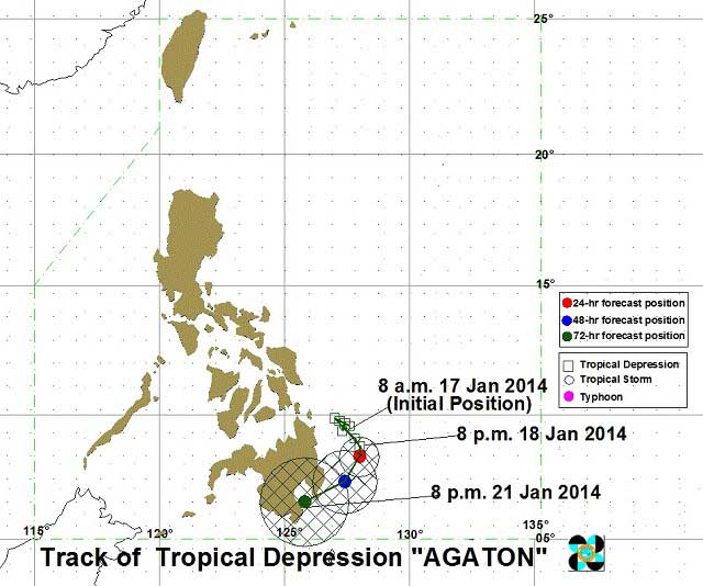
By Sunday evening, Agaton is expected to be 190 km east of Hinatuan, Surigao del Sur. By Monday evening, January 20, it is forecast to be 170 km southeast of Hinatuan, Surigao del Sur. On Tuesday evening, January 21, it is expected to be 90 km south of Davao City.
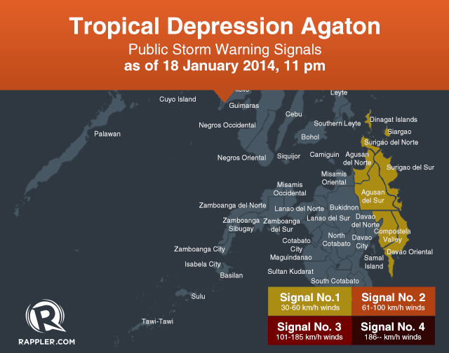
Storm signal number 1 is still hoisted over 7 areas, with winds of 30-60 km/h expected in at least 36 hours:
- Surigao del Norte including Siargao Is.
- Surigao del Sur
- Dinagat Province
- Agusan del Norte
- Agusan del Sur
- Davao Oriental
- Compostella Valley
Agaton is expected to lose strength during landfall, Weather Philippines said, and will weaken further into a low pressure area in 24 hours as it passes across the landmass of Southern Caraga, Davao and Northern Mindanao Regions. – Rappler.com
Help report critical information such as flooding, road or building damage, or those who need rescue or assistance using the Project Agos disaster information map. Rappler’s MovePH team will monitor the map and alert the relevant local authorities.
Add a comment
How does this make you feel?
There are no comments yet. Add your comment to start the conversation.