SUMMARY
This is AI generated summarization, which may have errors. For context, always refer to the full article.
What’s the weather like in your area? Tweet us the situation: Use #weatheralert and tag @rapplerdotcom.
MANILA, Philippines (UPDATED) – Heavy rain and winds pound large parts of the Bicol region late Tuesday afternoon, July 15, as Typhoon Glenda (international codename Rammasun) closes in on the region, state weather bureau PAGASA said.
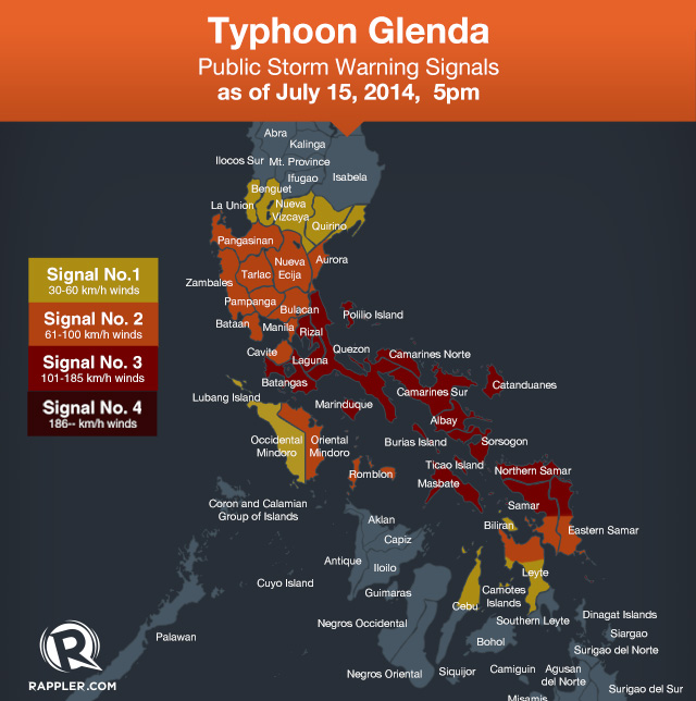
The entire Bicol region, plus parts of Eastern Visayas and Southern Luzon, has been put under Public Storm Warning Signal No 3, while Storm Signal No 2 has been declared over Metro Manila. (READ: #GlendaPH: Latest info and critical alerts)
As of 4 pm Tuesday, PAGASA last spotted the typhoon 60 kilometers east of Legazpi City, carrying maximum sustained winds of 130 km/h near the center, and gusts of up to 160 km/h.
It is forecast to move westward at a speed of 19 kph.
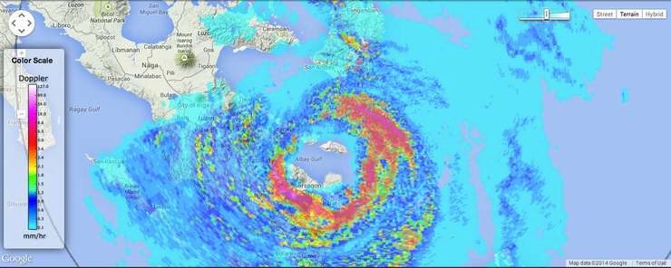
Radar images provided by the National Operational Assessment of Hazards (NOAH) showed that as of 5 pm, the eye was currently the Albay Gulf, with the eyewall – where the strongest rain and winds are – hitting Sorsogon City and the Rapu-Rapu islands.
“It is expected to pass Metro Manila before noon tomorrow and in the vicinity of Bataan in the afternoon and will move towards the West Philippine Sea. By Thursday afternoon, it will be at 370 km West of Sinait, Ilocos Sur outside the Philippine Area of Responsibility,” the bureau said in its 5pm severe weather bulletin.
PAGASA put the following areas under storm warning signals:
Public Storm Warning Signal #3 (Winds of 101-185 kph is expected in at least 18 hours)
- Catanduanes
- Albay
- Sorsogon
- Camarines Sur
- Camarines Norte
- Masbate
- Quezon including Polillo Islands
- Marinduque
- Laguna
- Batangas
- Rizal
- Northern Samar
- Northern parts of Samar and Eastern Samar
Public Storm Warning Signal #2 (Winds of 61-100 kph is expected in at least 24 hours)
- Cavite
- Southern Aurora
- Bulacan
- Pampanga
- Bataan
- Nueva Ecija
- Pangasinan
- Tarlac
- Zambales
- Lubang Island
- Oriental Mindoro
- Metro Manila
- Romblon
- Biliran
- Rest of Samar and Eastern Samar
- Northern part of Leyte province
Public Storm Warning Signal #1 (winds of 30 – 60 kph is expected in at least 36 hours)
- Northern Aurora
- Occidental Mindoro
- Quirino
- Nueva Vizcaya
- Benguet
- La Union
- Rest of Leyte
- Camotes Islands
- Northern Cebu including Cebu City
Moderate to intense rainfall (7.5-20 millimeters per hour) is expected within the typhoon’s 500 km diameter.
“Residents in low lying and mountainous areas under Signal Nos 3, 2 and 1 are alerted against possible flash floods and landslides. Likewise, those living in coastal areas under Signal Nos 3 and 2 are alerted against storm surges,” the bureau warned.
Gale warnings have also been issued, covering the eastern seaboards of northern and central Luzon, as well as waters off the Visayas islands. Seas in these areas are forecast to be rough to very rough, and could be dangerous for small seacraft.
Forecast tracks issued by the Japan Meteorological Agency and the US Navy Joint Typhoon Warning Center both show the typhoon passing through Bicol and Southern Luzon, and exiting near Zambales, after passing near Metro Manila.
Similar strength, track as 1983 storm
Independent weather organization Weather Philippines, in its latest bulletin Tuesday, said Glenda will weaken as it crosses Bicol and Southern Luzon, but will regain its strength once it reaches the waters of the West Philippine Sea.
Glenda is expected to leave the Philippine Area of Responsibility either on Thursday evening (July 16) or Friday morning (July 17).
Weather Philippines noted that the typhoon has a similar track and strength as Typhoon Vera (Philippine codename Bebeng), which hit July 14, 1983.
‘Preparing for the worst’
Glenda will be the first to make landfall since this year’s rainy season began in June, and authorities as well as local media were seeking to ensure all potentially impacted communities were well informed and prepared.
“We are preparing for the worst… it is critical now that we finish the evacuations,” said Rafaelito Alejandro, the regional civil defense chief of Bicol.
About 6,000 residents had already moved to evacuation centers, with authorities aiming to have another 39,000 take shelter before the typhoon hits, he said.
“If we can finish the evacuation, then it’s just a waiting game to see what happens,” Alejandro told Agence France-Presse by telephone.
The government cancelled most classes in Manila and Bicol on Tuesday, while dozens of domestic flights were also grounded.
The coastguard also shut down domestic shipping across Bicol, leaving more than 1,600 ferry passengers stranded.
Its international codename, Rammasun, is Thai for “God of Thunder”. – With reports from Agence France-Presse/Rappler.com
Stay alert and ready with the latest weather and disaster information through Project Agos.
Add a comment
How does this make you feel?
There are no comments yet. Add your comment to start the conversation.