SUMMARY
This is AI generated summarization, which may have errors. For context, always refer to the full article.
MANILA, Philippines (UPDATED) – Typhoon Glenda (international codename Rammasun) is expected to cross Metro Manila before noon Wednesday, July 16, and will exit Luzon via Zambales by Wednesday evening, according to national weather service PAGASA’s 11 pm bulletin Tuesday, July 15.
Metro Manila is already under Storm Signal No 3, along with surrounding provinces, according to PAGASA.
The Manila City Disaster Risk Reduction and Management Office ordered the mandatory evacuation of residents living in flood-prone areas, such as Baseco, Isla Puting Bato, Happy Land, and Old Sta Mesa.
At 10:45 p.m. Tuesday, the eye of Typhoon Glenda was located based on all available data and Baler Radar Station at 65 km Southeast of Alabat, Quezon province (13.6°N, 122.6°E). PAGASA put the typhoon’s maximum sustained winds at 150 kph near the center with gustiness of up to 185 kph.
The typhoon was intensifying further as it traversed Ragay Gulf and moved towards Southern Quezon. PAGASA put the estimated rainfall amount at 7.5 – 30.0 mm per hour (moderate to intense) within the 500 km diameter of the typhoon.
Residents in low-lying and mountainous areas under signal numbers 3, 2, & 1 are alerted against possible flashfloods and landslides. Those living in coastal areas under signals 3 and 2 are alerted against storm surges of up to 3 meters.
Fishing boats and other small sea crafts are advised not to venture out into the Eastern seaboards of Luzon and Visayas.
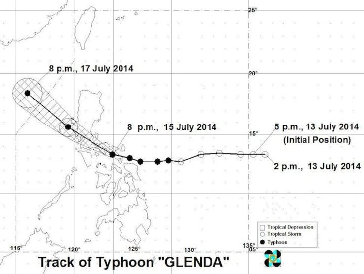
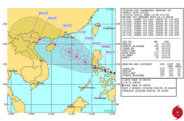
According to the Joint Typhoon Warning Center (JTWC), typhoon Glenda will weaken considerably as it tracks across Southern Luzon and Manila over the next 12 hours.
The JTWC said the typhoon is expected to intensify again as it emerges over the South China Sea and will peak prior to making landfall over Hainan Island. It will maintain strength until its final landfall in Northern Vietnam near Hanoi.
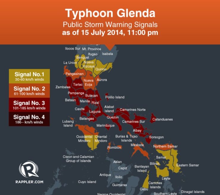
PAGASA Public Storm Warning No. 3 (Winds of 101-185 kph is expected in at least 18 hours)
- Catanduanes
- Albay
- Sorsogon
- CamarinesNorte
- CamarinesSur
- Quezon including Polillo Islands and Alabat Island
- Marinduque
- Laguna
- Batangas
- Rizal
- Burias and Ticao Islands
- Cavite
- Bulacan
- Bataan
- Pampanga
- Tarlac
- Zambales
- Metro Manila
Public Storm Warning No. 2 (Winds of 61-100 Kph is expected in at least 24 hours)
- Southern Aurora
- Nueva Ecija
- Pangasinan
- Romblon
- Masbate
- Northern parts of Oriental Mindoro and Occidental Mindoro including Lubang Island
- NorthernSamar
Public Storm Warning No. 1 (Winds of 30-60 Kph is expected in at least 36 hours)
- Rest of Aurora
- Quirino
- Nueva Vizcaya
- Benguet
- La Union
- Rest of Oriental Mindoro and OccidentalMindoro
- Biliran
- Northern Cebu including Cebu City, Camotes Islands, and Bantayan Island
- Northern part of Leyte
- Eastern Samar
- Samar
Public Storm Warning signals elsewhere have been lowered. – Rappler.com
Add a comment
How does this make you feel?
There are no comments yet. Add your comment to start the conversation.