SUMMARY
This is AI generated summarization, which may have errors. For context, always refer to the full article.
What’s the weather like in your area? Tweet us the situation: Use #weatheralert and tag @rapplerdotcom
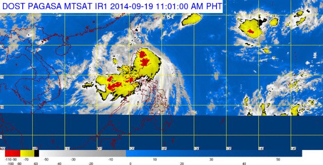
MANILA, Philippines (3rd UPDATE) – Tropical Storm Mario (Fung-Wong) hit land late Friday morning, September 19, as it maintained its strength.
State weather bureau PAGASA said the tropical storm has made landfall over the northern tip of Cagayan.
As of 10 am Friday, the center of Mario was located at 64 km north northeast of Tuguegarao City. The tropical storm packs maximum sustained winds of 85 km per hour near the center and gustiness of up to 100 km per hour.
It is seen to move west northwest at 22 km per hour, PAGASA said, with moderate to intense rains (7 to 20 mm per hour) within the tropical storm’s 350-km diameter. (#MarioPH: Help map critical reports)
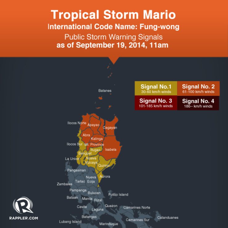
PAGASA has raised public storm warning signal number 2 over the following areas:
- Cagayan including Calayan, Babuyan and Batanes Group of Islands
- Isabela
- Kalinga
- Apayao
- Mt. Province
- Abra
- Ilocos Norte
- Batanes Group of Islands
Meanwhile, public storm warning signal number 1 is raised over:
- Aurora
- Quirino
- Nueva Vizcaya
- Ifugao
- Benguet
- Ilocos Sur
- La Union
Residents in these areas are alerted against possible flashfloods and landslides.
The combined effects of Mario and the southwest monsoon will bring moderate to heavy rains and thunderstorms in Metro Manila and the rest of Luzon which may also trigger flashfloods and landslides.
Mario is expected to be in the vicinity of Calayan, Cagayan by Friday evening; at 190 km northwest of Itbayat, Batanes, by Saturday morning, September 20; and, at 680 km north of Itbayat, Batanes – out of the Philippine Area of Responsibility – by Sunday evening, September 21.
The next bulletin for Mario will be issued at 5 pm Friday.
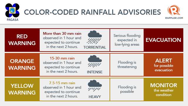
As of 12 nn, PAGASA hoisted heavy rainfall alerts over the the following areas
Red rainfall warning
- Metro Manila
- Bulacan
- Rizal
- Laguna
- Cavite
- Batangas
Orange rainfall warning
- Quezon
- Pampanga
- Zambales
- Bataan
Yellow rainfall warning
- Tarlac
- Nueva Ecija
Follow Rappler’s live blog for more information, photos, and videos from areas affected by Typhoon #MarioPH (Fung-Wong). – Rappler.com
Add a comment
How does this make you feel?
There are no comments yet. Add your comment to start the conversation.