SUMMARY
This is AI generated summarization, which may have errors. For context, always refer to the full article.
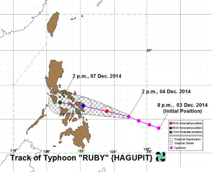
MANILA, Philippines – Typhoon Ruby (international name Hagupit) has intensified as it moves toward Eastern Visayas, state weather bureau PAGASA said on Thursday afternoon, December 4.
As of 4 pm Thursday, the center of Ruby was located at 720 km east of Surigao City with winds of up to 205 km/hour near the center, and gustiness of up to 240 km/hour.
It will move west northwest in direction at 15 km/hour, with rainfall amount of 7.5 mm to 20 mm per hour (heavy–intense) within its 700-km diameter.
Ruby will be 360 km east of Guiuan, Eastern Samar on Friday afternoon, December 5 and is expected to hit land in the Eastern Samar-Northern Samar area by Saturday afternoon, December 6. (READ: #RubyPH: Big chance hitting E. Samar by Saturday)
It will be 30 km west southwest of Romblon, Romblon on Sunday afternoon, December 7.
PAGASA raised public storm warning signal number 2 over 8 areas:
- Northern Samar
- Eastern Samar
- Samar
- Biliran
- Leyte
- Southern Leyte
- Dinagat Island
- Siargao Island
Meanwhile, public storm warning signal number 1 has been raised over 10 areas:
- Catanduanes
- Albay
- Sorsogon
- Masbate including Ticao Island
- Northern Cebu, including Bantayan Island and Camotes Island
- Bohol
- Surigao del Norte
- Surigao del Sur
- Camiguin Island
- Agusan del Norte
Areas under public storm warning signals can expect moderate to heavy rains in the next 24 to 36 hours. PAGASA warned residents in low lying and mountainous areas against possible flashfloods and landslides, while storm surges are possible for those living near coastal areas.
Project NOAH executive director Mahar Lagmay earlier said storm surges of 3.5 to 4 meters are expected in parts of Eastern Visayas, and the highest surges are likely in Catarman, Borongan and Guiuan in Samar and the Tacloban Straight in Leyte.
The typhoon and a northeast monsoon will bring rough to very rough sea conditions over the seaboards of Northern Luzon, eastern seaboard of Central and Southern Luzon, over the seaboards of Visayas and over the northern and eastern seaboards of Mindanao.
The next bulletin on Ruby will be issued at 11 pm Thursday. – Rappler.com
Stay alert and ready with the latest weather and disaster information through Project Agos.
Add a comment
How does this make you feel?
There are no comments yet. Add your comment to start the conversation.