SUMMARY
This is AI generated summarization, which may have errors. For context, always refer to the full article.
What’s the weather like in your area? Tweet us the situation: Use #weatheralert and tag @rapplerdotcom
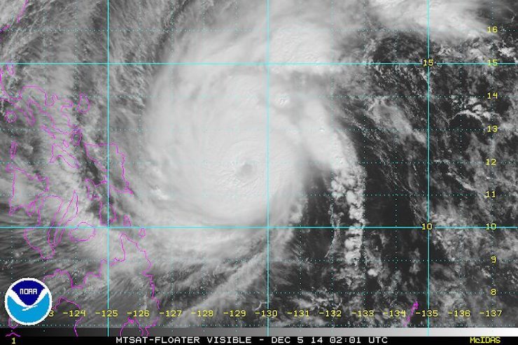
MANILA, Philippines – Typhoon Ruby (Hagupit) maintained its strength Friday morning, December 5, as state forecasters predict landfall in the northern area of Samar island by Saturday, December 6.
Ruby, located 435 kilometers east of Borongan, Eastern Samar as of 10 am Friday, currently has maximum sustained winds of 215 km/h near the center and gusts of up to 250 km/h, state weather bureau PAGASA said in its 11 am bulletin.
The US Navy’s Joint Typhoon Warning Center (JTWC) has downgraded Ruby into a typhoon. Previously, the JTWC labeled the system as a super typhoon. Despite this, the storm still has considerable strength.
Heavy to intense rainfall (7.5-20 mm/h) is expected within the typhoon’s 700 km diameter, the bureau said.
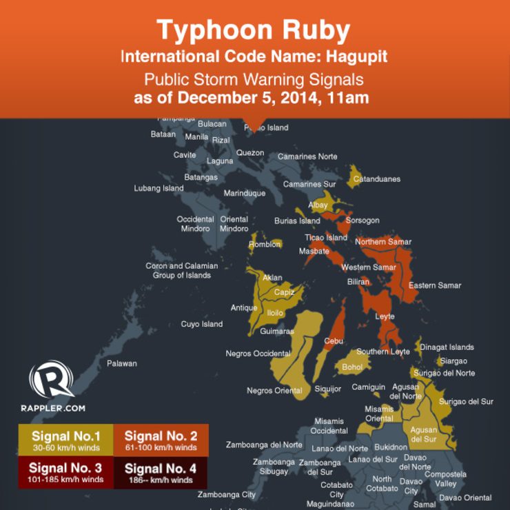
Public storm warning signal number 2, where winds between 61-100 km/h can be expected with 24 hours, has been raised over these areas:
- Sorsogon
- Ticao Island
- Masbate
- Northern Samar
- Eastern Samar
- Samar
- Biliran
- Leyte
- Southern Leyte
- Northern Cebu including Cebu City
- Bantayan Island
- Camotes Island
Signal number 1, where winds between 30-60 km/h can be expected within 36 hours has been raised over these areas:
- Catanduanes
- Albay
- Camarines Norte
- Camarines Sur
- Burias Island
- Romblon
- Capiz
- Iloilo
- Antique
- Aklan
- Negros Oriental
- Negros Occidental
- Rest of Cebu
- Siquijor
- Bohol
- Surigao del Sur
- Agusan del Norte
- Surigao del Norte
- Dinagat Island
- Siargao Island
- Misamis Oriental
- Agusan del Sur
- Camiguin Island
The typhoon is still moving at a pace of 13 km/h, moving west northwest, the bureau said.
The typhoon is still expected to make landfall in the area of Eastern Samar and Northern Samar on Saturday evening, December 6, “and will be associated with strong winds, storm surge, and heavy to intense rainfall,” PAGASA said.
It is forecast to exit the Philippine Area of Responsibility by Wednesday morning, December 10.
Ruby and the northeast monsoon are expected to bring “rough to very rough” seas in northern Luzon, eastern coasts of Central and Southern Luzon, the Visayas, and northern and eastern Mindanao. Storm surges of up to 4 meters high are possible.
“Fisherfolks and those using small seacraft are advised not to venture out over the said seaboards. Moreover, those living near coastal areas are alerted against possible storm surges,” the bulletin said.
With Ruby approaching, stormy weather can be expected in Eastern Visayas, Caraga, Sorsogon, Masbate, and northern Cebu within 24 hours, the bureau said in its regular forecast, also issued 5 am.
The rest of the Visayas, Bicol, and the provinces of Misamis Oriental, Camiguin, and Romblon will experience rain with gusty winds, the bureau said.
Cagayan Valley, Cordillera, and Ilocos regions will have cloudy skies accompanied by light rain, while the rest of the archipelago, including Metropolitan Manila, will have cloudy skies with light to moderate rain.
The next bulletin on Ruby will be issued at 5 pm. – Rappler.com
Add a comment
How does this make you feel?


There are no comments yet. Add your comment to start the conversation.