SUMMARY
This is AI generated summarization, which may have errors. For context, always refer to the full article.
What’s the weather like in your area? Tweet us the situation: Use #weatheralert and tag @rapplerdotcom.
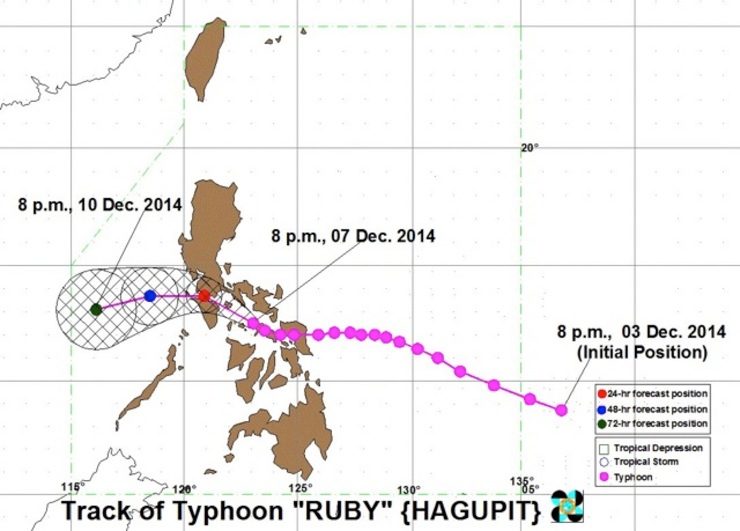
MANILA, Philippines (UPDATED) – Typhoon Ruby (international name: Hagupit) is expected to make its 3rd landfall over the northern part of the Mindoro provinces between 6 pm and 8 pm Monday, December 8, according to state weather bureau PAGASA.
As of 10 pm Sunday, December 7, the eye of the typhoon was located at 70 km northwest of Masbate City. PAGASA said it is now traversing the Sibuyan Sea.
It has maintained strength, with maximum sustained winds of 140 km/h near the center, and gustiness of up to 170 km/h.
Ruby first hit land in Dolores, Eastern Samar, on Saturday night, December 6, and made its 2nd landfall in Cataingan, Masbate, on Sunday morning.
PAGASA earlier forecasted that Ruby would make landfall on the islands of Sibuyan, Romblon, and Tablas on Sunday before hitting Oriental Mindoro Monday morning.
But PAGASA forecaster Glaiza Escullar told Rappler in a phone interview that the typhoon shifted a few degrees to the north, skipping landfall on the said islands. Ruby is now seen to make its 3rd and last landfall over northern Mindoro on Monday evening, December 8, between 6 pm and 8 pm.
The typhoon will bring strong winds, storm surge, and moderate to heavy rainfall.
The effects of the typhoon will be felt in Metro Manila starting Monday, and will peak at around 8 pm to 10 pm.
Ruby is moving west northwest – still at 10 km/h, but with moderate to heavy rainfall (5 to 15 mm/h) expected within its 450-km diameter.
Public Storm Warning Signal Number 3 – with winds between 101-185 km/h expected in at least 18 hours – has been hoisted over 12 areas:
- Masbate
- Ticao Island
- Burias Island
- Marinduque
- Romblon
- Oriental Mindoro
- Occidental Mindoro
- Batangas
- Laguna
- Cavite
- Southern Quezon
- Lubang Island
Storm Signal Number 2 has been raised over 15 areas, which can expect winds between 61 to 100 km/h in at least 24 hours:
- Calamian Group of Islands
- Bulacan
- Bataan
- Rest of Quezon
- Rizal
- Sorsogon
- Albay
- Camarines Sur
- Camarines Norte
- Metro Manila
- Semirara Island
- Biliran
- Aklan
- Capiz
- Bantayan Island
PAGASA also raised Signal Number 1 – with winds between 30 to 60 km/h expected in at least 36 hours – over 16 areas:
- Polillo Island
- Zambales
- Nueva Ecija
- Tarlac
- Pampanga
- Catanduanes
- Northern Palawan including Cuyo
- Northern Samar
- Eastern Samar
- Samar
- Leyte
- Iloilo
- Antique
- Guimaras
- Negros Occidental
- Northern Cebu including Cebu City and Camotes Island
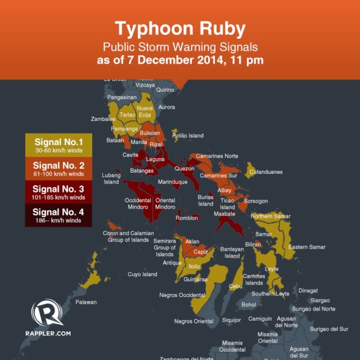
PAGASA warned residents in low-lying and mountainous areas against flashfloods and landslides. Coastal areas under Signal Number 3 are warned against big waves associated with storm surges which may reach up to 3 meters.
Ruby is expected to exit the Philippine Area of Responsibility (PAR) by Thursday morning, December 11.
“Ruby and the Northeast Monsoon will cause rough to very rough sea conditions over the seaboards of Luzon and Visayas and over the northern seaboard of Mindanao,” the bureau said.
The next bulletin on Typhoon Ruby will be released at 5 am on Monday. – Rappler.com
Get the latest #WeatherAlert and typhoon updates on Project Agos.
Add a comment
How does this make you feel?
There are no comments yet. Add your comment to start the conversation.