SUMMARY
This is AI generated summarization, which may have errors. For context, always refer to the full article.
What’s the weather like in your area? Tweet us the situation: Use #weatheralert and tag @rapplerdotcom
MANILA, Philippines (UPDATED) – Tropical Storm Amang (international name Mekkhala) intensified late evening of Friday, January 16, prompting PAGASA to put the entire Samar Island under Public Storm Warning Signal No 2.
The weather agency warns of light to moderate with occasionally heavy rains that will affect Eastern Visayas that may continue for 2 – 3 hours. Possible flooding may occur in low-lying areas, while landslides may occur in mountainous areas.
Spotted 330 kilometers east of Borongan City, Eastern Samar, Amang now packs winds with speeds of 85 to 100 kilometers per hour (km/h), according to state weather bureau PAGASA’s Friday, 11 pm bulletin.
It was an increase from the storm’s wind speeds recorded by the agency at 4 pm – 75 to 90 km/h.
Independent weather station Weather Philippines had an even grimmer forecast, saying the storm “rapidly” intensified.
The group’s senior typhoon specialist Mike Padua told Rappler that as of 11 pm, the range of wind speeds detected was 95 km/h to 120 km/h. Though still far from being a typhoon, Amang can be considered a “strong tropical storm,” said Padua.
Foreign weather stations like the Japan Meteorological Agency and the US’ Joint Typhoon Warning Center also peg maximum sustained winds at 95 km/h.
New storm signals
PAGASA raised Public Storm Warning Signals in the following areas:

Storm Signal No 2:
- Northern Samar
- Eastern Samar
- Samar
Storm Signal No 1:
- Southern Quezon
- Camarines Norte
- Camarines Sur
- Catanduanes
- Albay
- Sorsogon
- Masbate (including Ticao and Burias islands)
- Leyte
- Southern Leyte
- Biliran
- Camotes Island
- Bantayan Island
- Extreme Northern Cebu
- Dinagat Island
It added that it may also put Northern Quezon, including Polillo island, under Storm Signal 1 in the next 6 hours depending on changes in the storm.
Areas under storm warning signal are asked to be alert for flashfloods and landslides. Those near the coast should expect ocean waves of up to 6.5 meters (21.3 feet).
Help map critical reports of flooding, road or building damage, rescue and assistance needs using the Project Agos disaster information map.
Landfall predictions
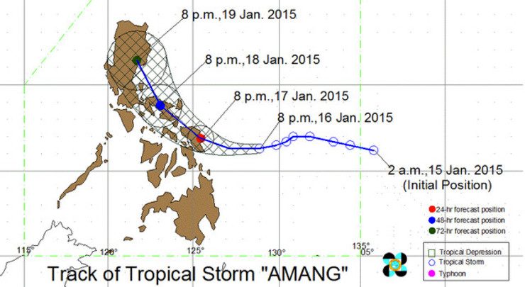
PAGASA predicts Amang will “slow down” and hit Borongan City, Eastern Samar by early morning on Sunday.
Weather Philippines meanwhile says the storm will make landfall in the northern shores of Eastern Samar on Saturday between 2 pm to 5 pm.
JTWC says Amang is likely to intensify right before landfall, possibly packing winds of up to 110 km/h.
The tracks predicted by the two weather monitoring groups also changed since earlier bulletins.
PAGASA’s latest track shows Amang curving slightly to the north up to Bicol and then to Cagayan Valley.
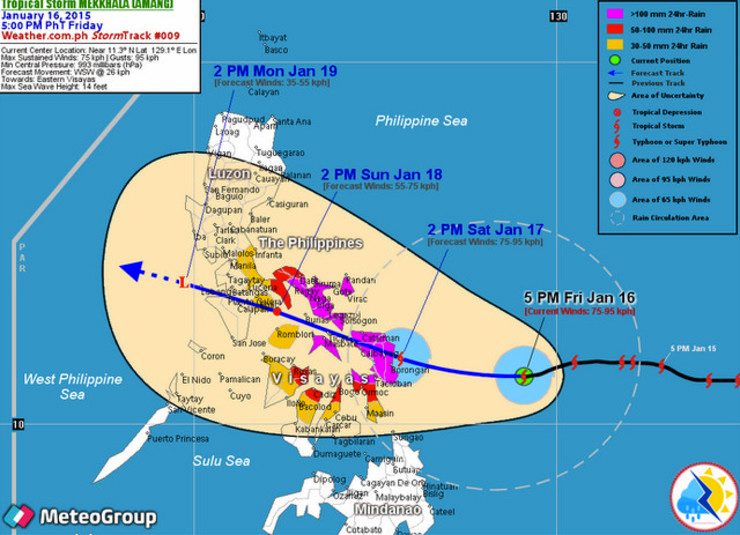
Weather Philippines’ track is similar to that of JTWC’s. In it, Amang continues its western track traversing Central Visayas and then on to Calabarzon and Mindoro Island. – Rappler.com
Add a comment
How does this make you feel?
There are no comments yet. Add your comment to start the conversation.