SUMMARY
This is AI generated summarization, which may have errors. For context, always refer to the full article.
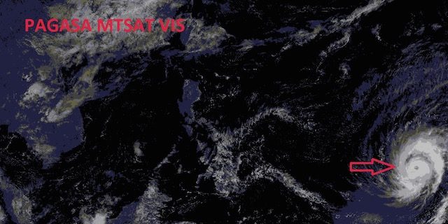
MANILA, Philippines – Typhoon Maysak has slightly gained speed as it moves closer to the Philippine Area of Responsibility (PAR) on Monday, March 30.
As of 10 am, Maysak was located 2,240 kilometers east of Mindanao, carrying maximum sustained winds of 140 km/h near the center and gusts of up to 170 km/h, state weather bureau PAGASA said in its weather advisory Monday.
The bureau said the typhoon is forecast to move west at a speed of 23 km/h.
Maysak is expected to enter the PAR by Wednesday, April 1. It is currently too far to affect any part of the country, the bureau said. Once it enters the PAR, it will be given the local codename Chedeng.
The typhoon is currently threatening the Western Micronesia area, particularly the islands of Yap and Ulithi, according to independent weather organization Weather Philippines.
Weather Philippines also said that based on current 5-6 day forecasts, the severe weather system could make a possible hit in the Bicol and Samar areas on Saturday, April 4, as a weakened storm. These forecasts, however, are bound to change as the typhoon is still too distant. – Rappler.com
Add a comment
How does this make you feel?


There are no comments yet. Add your comment to start the conversation.