SUMMARY
This is AI generated summarization, which may have errors. For context, always refer to the full article.
What’s the weather like in your area? Tweet us the situation: Use #weatheralert and tag @rapplerdotcom
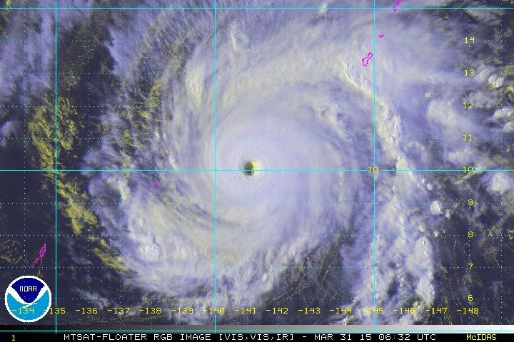
MANILA, Philippines – Typhoon Maysak has been upgraded to a super typhoon status as it traverses the northwestern Pacific Ocean, the United States Navy’s Joint Typhoon Warning Center (JTWC) said on Tuesday, March 31.
As of posting, the eye of the super typhoon was located northeast of Ulithi, an atoll in the Caroline Islands.
In its Tuesday night bulletin, however, state weather bureau PAGASA maintained that Maysak was still a typhoon. It spotted the storm 1,690 kilometers east of Surigao City, Surigao Del Norte at 4 pm on Tuesday, March 31. (READ: Typhoon Maysak retains strength as it nears PAR)
Maysak continued to pack winds of 175 kilometers per hour (km/h) near the center and gusts of up to 210 km/h, its wind speeds forecast earlier that day at 11 am. It is moving west northwest at a speed of 20 km/h. JTWC recorded a stronger maximum sustained winds of 145 KT (259.28 km/h) and gustiness of 175 KT (324.1 km/h) for Maysak. The JTWC numbers are based on one-minute sustained wind speeds, while PAGASA’s are based on 10-minute periods.
Independent local weather organization Weather Philippines, meanwhile, recorded a maximum sustained winds of 240 km/h near the center and gustiness of 295 km/h, based on an alert it released Tuesday afternoon.
Weather Philippines also upgraded Maysak into a Super Typhoon.
However, the JTWC, Weather Philippines, and the Japan Meteorological Agency (JMA) all forecast that Maysak will weaken in the next few days as it enters the Philippine Area of Responsibility (PAR).
“Maysak will continue to gain strength within the next 24 hours, before it starts its weakening trend through 48 hours,” according to the Weather Philippines.
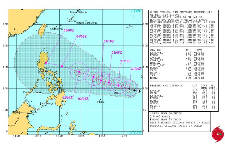
In its Tuesday night bulletin, PAGASA said Maysak is expected to enter PAR by Wednesday evening (April 1) or Thursday morning (April 2). It will be given the name “Chedeng” when it enters PAR.
Already wreaking havoc
Neville Koop, a meteorologist with Fiji’s Na Draki weather service, said at its peak it would have winds of 270 kilometres per hour (168 miles per hour) with gusts up to 340 km/h.
“This typhoon will be very destructive,” Koop told Agence France-Presse. “At its peak Typhoon Maysak will be as strong as Cyclone Pam.”
Severe Tropical Cyclone Pam slammed into Vanuatu over two weeks ago, causing widespread damage and leaving 11 people dead in the South Pacific nation.
The island of Chuuk, part of the Federated States of Micronesia (FSM), received a direct hit late on Sunday, March 29, and the Yap group was next in its path.
“Chuuk was devastated,” lawyer Kembo Mida said in an email to the Ayuda Foundation relief organization which is based in Guam about 1,000 km (600 miles) away.
“Houses were blown away and trees snapped in half. It was very dangerous and scary… a ship sank too.”
The director of the FSM National Emergency Management Office, Andrew Yatilman, told Radio New Zealand that Typhoon Maysak scored a direct hit on the most populated area of Chuuk, which is home to nearly 50,000 people.
“Residences (had) their roofs completely torn off, and so whoever was staying in those will have to be accommodated either by relatives or in public shelters that have been set up by the government,” he said.
“Most people are all right, we understand that there may have been a few casualties; between four and five that we know so far.”
In 2002, heavy rain from Tropical Storm Chataan triggered several landslides that killed 47 people in Chuuk’s deadliest weather disaster. – With reports from Agence France-Presse/ Rappler.com
Add a comment
How does this make you feel?
There are no comments yet. Add your comment to start the conversation.