SUMMARY
This is AI generated summarization, which may have errors. For context, always refer to the full article.
What’s the weather like in your area? Tweet us the situation: Use #weatheralert and tag @rapplerdotcom
MANILA, Philippines [UPDATED] – More areas are now under storm signals as Typhoon Chedeng (Maysak) maintained its intensity Saturday morning, April 4. It is moving closer to the Isabela-Aurora area, according to state weather bureau PAGASA.
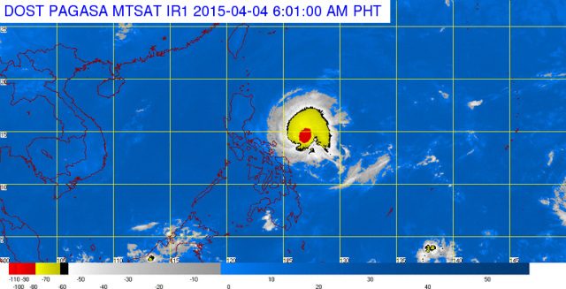
As of 4 am Saturday, Chedeng was located 625 kilometers east southeast of Casiguran, Aurora, with maximum sustained winds of 130 kilometers/hour (km/h) near the center, and gusts of up to 160 km/h.
It is moving west northwest at 19 km/h, with moderate to heavy rainfall expected within its 150-km radius.
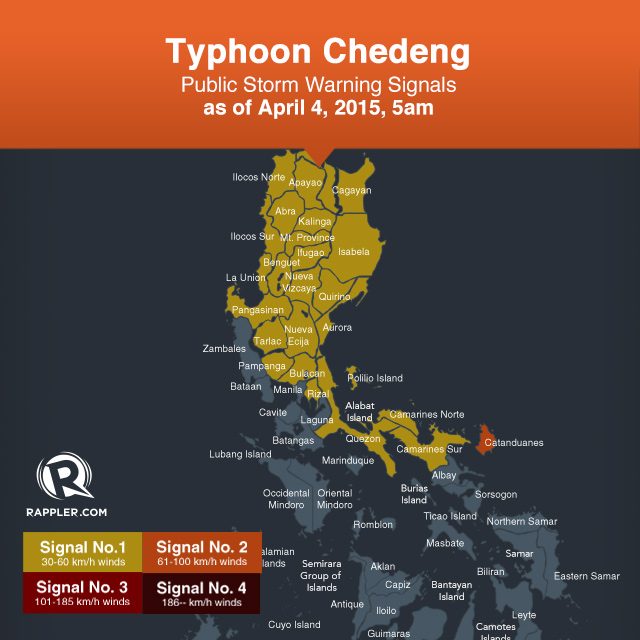
Public Storm Warning Signal Number 2 is still raised over Catanduanes. Winds of 61-100 km/h are expected in this province in at least 24 hours.
A total of 23 areas are now under public Storm Warning Signal No. 1 (with winds of 30-60 km/h expected in at least 36 hours):
- Camarines Sur
- Camarines Norte
- Quezon, including Polillo Island
- Rizal
- Bulacan
- Pampanga
- Tarlac
- Nueva Ecija
- Pangasinan
- La Union
- Ilocos Norte
- Ilocos Sur
- Abra
- Apayao
- Cagayan
- Benguet
- Kalinga
- Aurora
- Quirino
- Nueva Vizcaya
- Ifugao
- Isabela
- Mountain Province
In provinces with storm signals, residents in low lying and mountainous areas are advised against possible flashfloods and landslides. (Visit the Agos Alert Map to view hazard maps showing areas that are vulnerable to rain-induced landslides, flashfloods and storm surges.)
“Storm surges and sea surface waves of up to 2 meters are possible over the eastern coast of Aurora, Quezon and Isabela. Fisherfolks are advised not to venture out over the northern seaboard of Northern Luzon and eastern seaboard of Bicol Region and of Visayas,” the bureau said in its 5 am Chedeng bulletin.
University of the Philippines Professor and Weather Manila meteorologist Dr. Gerry Bagtasa warns that while Chedeng has weakened compared to its peak strength, it will still be a fairly strong storm when it finally hits land.
Different models-the US-based Joint Typhoon Warning Centre (JTWC) and the Japan Meteorological Agency (JMA) predict that windspeed would be at 90 to 100 kph upon landfall, according to Bagtasa.
“This may not enough to uproot trees but it can bend trees. And branches might fall.”
Bagtasa also points out that the height of waves in beaches would be higher than normal. “People are definitely advised not go island hopping. Even swimming in the shallower portions would still be dangerous because of high waves.”
Authorities have warned tourists in affected areas like Baler, Tayabas to reconsider plans ahead of Chedeng’s landfall.
While the past few days have been relatively sunny, Bagtasa says people should not be complacent.
“It’s summer so that accounts for the fact that they don’t feel the wind right now.” The impact of tropical cyclones, Bagtasa notes, are typically confined to the radius of the storm. “Chedeng is also not moving that fast. It’s still far from land.”
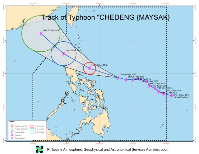
The typhoon is expected to make landfall over the coast of the Aurora-Isabela area by Sunday morning, April 5.
Meanwhile, in its April 4, 8:52 am update, Weather Philippines said Chedeng’s outer rainbands will bring moderate to heavy rains across Northern Bicol beginning Saturday through Sunday Afternoon (Apr 05).
Moderate to heavy rains will likewise be experienced across Northern Quezon and most of the eastern provinces of Northern Luzon beginning Sunday morning, according to the same update.
PAGASA said Chedeng will exit the landmass via Ilocos Sur by Sunday evening, and will exit the Philippine Area of Responsibility by Monday morning, April 6.
The next PAGASA bulletin on the typhoon will be issued at 11 am Saturday. – Rappler.com
Add a comment
How does this make you feel?


There are no comments yet. Add your comment to start the conversation.