SUMMARY
This is AI generated summarization, which may have errors. For context, always refer to the full article.
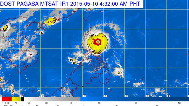
MANILA, Philippines (UPDATED) – Typhoon Dodong (international name: Noul) intensified further on Sunday morning, May 10, as it moves closer to northern Luzon, placing 5 areas under storm warning signal number 3.
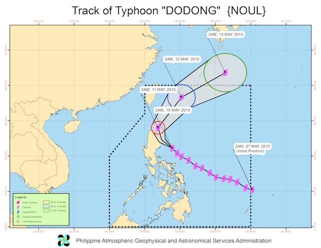
As of 5 am Sunday, Dodong was spotted 240 kilometers east northeast of Baler, Aurora or 170 kilometers east of Casiguran Aurora (16.4°N, 123.7°E)
Packing maximum sustained winds of 170 kilometers per hour near the center and gustiness of up to 205 kilometers per hour, the typhoon is forecast move northwest at 17 kilometers per hour.
Dodong is expected to hit the northeastern tip of Cagayan Valley – the town of Santa Ana – Sunday afternoon or early evening, PAGASA said in a televised 9am update.
State weather bureau PAGASA said Dodong is estimated to bring in heavy to intense rain within the 150 kilometer diameter of the typhoon.
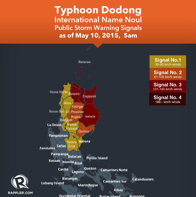
Public storm warning signal number 3 was hoisted over the following areas:
- Cagayan
- Babuyan Group of Islands
- Calayan Group of Islands
- Isabela
- Apayao
Here are the areas under storm warning signal number 2:
- Northern Aurora
- Kalinga
- Mountain Province
- Ifugao
- Batanes
- Quirino
These areas were placed under public storm warning signal number 1:
- Rest of Aurora
- Abra
- Ilocos Sur
- Ilocos Norte
- Benguet
- Nueva Vizcaya
- Nueva Ecija
PAGASA warned fisherfolks against venturing out to the eastern seabord of Southern Luzon.
For those located in coastal areas, storm surges of up to 1.50 meters are possible over the easter coast of Isabela and Cagayan, PAGASA said.
Tourists and travellers are advised to advised to avoid beaches along the easter section of Isabela and Cagayan.
Dodong is expected to exit the Philippine Area of Responsibility Tuesday morning, May 12.
The US Navy’s Joint Typhoon Warning Center (JTWC) has labeled Dodong a super typhoon, and the center calculated winds of up to 130 kts (240 km/h) with gusts of up to 160 kts (296 km/h), using 1-minute maximum sustained wind speed measurements.
The Japan Meteorological Agency (JMA) tagged the storm as “violent.”
Evacuations
Over 1,200 people have already been pre-emptively evacuated from the areas expected to be affected by Noul, said National Disaster and Risk Reduction Council spokesperson Mina Marasigan.
“There are areas which can have landslides. There are areas which can have flash floods. There are coastal areas which can be hit by storm surges as high as 1.5 meters,” she told Agence France–Presse.
Storm surges – tsunami-like waves generated by powerful typhoons – have become a major concern during storms.
In November 2013 storm surges were the main killers as Super Typhoon Haiyan ravaged the central Philippines, leaving more than 7,350 people dead or missing.
Several hundred people living in a farming hamlet below the restive Bulusan volcano on Luzon have also been evacuated due to the potential that rain could mix with volcanic ash accumulated on the volcano’s slopes to form deadly, fast-moving mudflows that could bury entire houses.
The government has already suspended ferry services in the affected areas and some domestic flights have also been cancelled as part of safety measures.
About 20 typhoons and storms hit the Philippines each year, many of them deadly.– with Agence France-Presse/Rappler.com
Add a comment
How does this make you feel?
There are no comments yet. Add your comment to start the conversation.