SUMMARY
This is AI generated summarization, which may have errors. For context, always refer to the full article.
What’s the weather like in your area? Tweet us the situation: Use #weatheralert and tag @rapplerdotcom
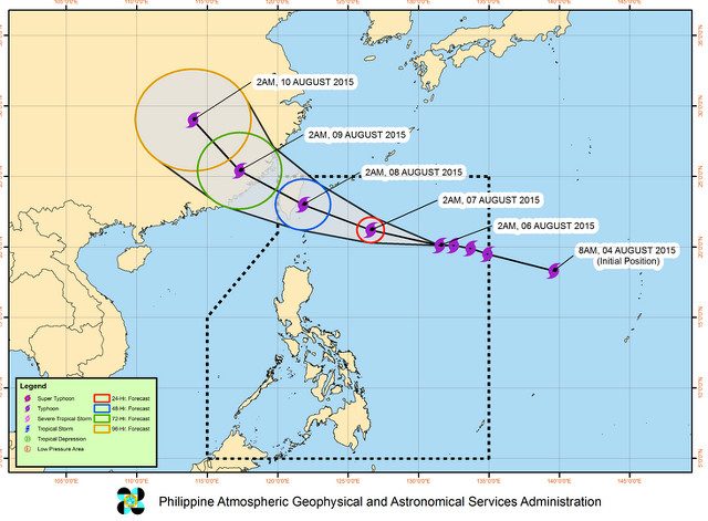
MANILA, Philippines – (UPDATED) Public Storm Warning Signal No 1 has been raised over Batanes in Nothern Luzon as Typhoon Hanna weakened further on Thursday morning, August 6.
Typhoon Hanna was spotted 825 kilometers east of Basco, Batanes at 10 am, said the Philippine Atmospheric, Geophysical and Astronomical Services Administration (PAGASA) in its morning typhoon update.
It weakened from earlier that morning, now packing maximum sustained winds of 165 km/h and gusts of up to 200 km/h. However, it will still bring moderate to heavy rains to areas within its 700-kilometer diameter.
The Batanes Group Islands can expect winds of 30 to 60 km/h in the next 36 hours.
Houses made of very light materials may get slightly damaged from such winds. Rice crops in the flowering stage may experience significant damage.
Waves at open sea may reach heights of 1.25 to 4 meters (4 to 13 feet).
Fishers are warned against venturing out to the Northern and Eastern seaboards of Luzon, and the seaboards of Palawan, Visayas, and Mindanao.
Monsoon rains, enhanced by Hanna, are also expected over Visayas, Mindanao, Bicol region and the province of Palawan. Such rains may trigger landslides and flashfloods, warned PAGASA.
Hanna will be outside PAR on Sunday morning.
The next typhoon update will be released at 5 pm. – Rappler.com
Add a comment
How does this make you feel?
There are no comments yet. Add your comment to start the conversation.