SUMMARY
This is AI generated summarization, which may have errors. For context, always refer to the full article.
(UPDATED) Signal No 2 is still raised over Batanes. A southwest monsoon is also affecting Calabarzon, Mimaropa, Bicol Region, and Visayas.
What’s the weather like in your area? Tweet us the situation: Use #weatheralert and tag @rapplerdotcom
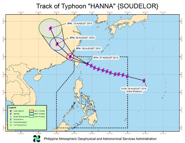
MANILA, Philippines (UPDATED) – Typhoon Hanna (international codename Soudelor) has maintained its strength as it continues to move closer towards the Taiwan area, state weather bureau PAGASA said on Friday evening, August 7.
The typhoon is expected to leave the Philippine Area of Responsibility by Saturday evening, August 8.
As of 10 pm Friday, the eye of Hanna was located 315 kilometers (km) northeast of Itbayat, Batanes. It has maximum sustained winds of 165 km/hour (km/h) near the center and gustiness of up to 200 km/h.
It is still moving west northwest at a speed of 20 km/h. Moderate to heavy rainfall is expected within the 750-km diameter of the typhoon.
Public Storm Warning Signal No 2 is still raised over the province of Batanes, which should expect 61 km/h to 120 km/h winds in the next 24 hours.
Storm surges are also possible in the coastal areas of the province, and the waves could reach heights of 4.1 meters to 14 meters.
Meanwhile, Northern Cagayan and the islands of Calayan and Babuyan are still under Public Storm Warning Signal No 1. These areas should expect 30 km/h to 60 km/h winds in the next 36 hours, and storm surges at open seas which could reach wave heights of 1.25 meters to 4 meters.
PAGASA warned fisher folk against venturing out over the seaboards of Luzon, Visayas, and Eastern Mindanao.
A southwest monsoon is affecting Calabarzon, Mimaropa, Bicol Region, and Visayas. Residents living in low lying and mountainous areas should stay alert against possible flashfloods and landslides.
The next bulletin on Hanna will be issued at 5 am Saturday. – Rappler.com
Add a comment
How does this make you feel?
Loading
There are no comments yet. Add your comment to start the conversation.