SUMMARY
This is AI generated summarization, which may have errors. For context, always refer to the full article.

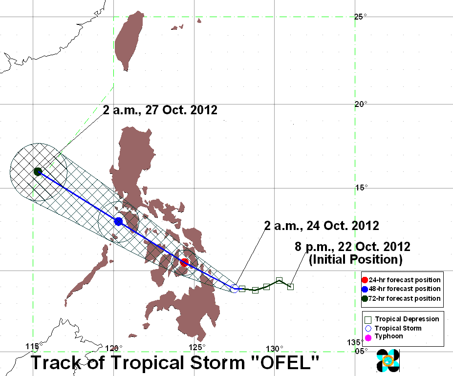
MANILA, Philippines (UPDATED) – The entire Visayas and CARAGA region are now under public storm warning signals as tropical storm Ofel (Son-Tinh) accelerated towards the area Wednesday morning, October 24.
Ofel was located just off the tip of Siargao Island (10.1°N, 126.0°E) as of 10 am, carrying maximum sustained winds of 65 km/h near the center and gustiness of up to 80 km/h, state weather bureau PAGASA said in its 11 am severe weather bulletin.
The storm is also carrying moderate to intense rainfall (5-20 mm/h) within is 400 km diameter.
Public storm warning signal number 2 has been raised over the following areas:
- Bohol
- Cebu
- Leyte
- Southern Leyte
- Dinagat Island
- Surigao del Norte
- Surigao del Sur
- Agusan del Norte
- Camiguin
- Northern towns of Agusan del Sur
These areas will have winds between 61-100 km/h in the next 36 hours.
Public storm warning signal number 1, meanwhile, has been raised over the following areas:
- The rest of Agusan del Sur
- Masbate
- Romblon
- Northern Samar
- Eastern Samar
- Samar
- Biliran
- Capiz
- Antique
- Aklan
- Iloilo
- Guimaras
- Negros Oriental
- Negros Occidental
- Siquijor
- Misamis Oriental
- Northern towns of Bukidnon
Winds of 30-60 km/h are forecast for these areas in the next 24 hours.
The storm is moving west northwest at 19 km/h, and based on PAGASA forecast tracks it is expected to cross Surigao del Norte, then over Visayas.
The storm is expected to be in the vicinity of Roxas City by Thursday morning, and will be 180 km west of Nasugbu, Batangas by Friday morning.
It will be out of the Philippine Area of Responsibility (PAR), particularly over the South China Sea (West Philippine Sea) by Saturday morning.
Forecast tracks predict Ofel moving forward toward either the the general area of Vietnam or towards southern China after leaving the Philippines.
Residents in areas with storm signals, particularly those living near bodies of water and near mountainsides, are warned of possible flooding and landslides.
Big waves caused by Ofel and the northeast monsoon, or the Amihan, are expected in the eastern coasts of Mindanao, Visayas, and southern Luzon. Small seacraft are warned not to venture out to sea in these areas.
On the other hand, Bicol, Mimaropa, and the rest of the Visayas and Mindanao will have cloudy skies with moderate to heavy rain or thunderstorms.
Metro Manila and the rest of Luzon will have partly cloudy skies with brief rain or thunderstorms.
Winds will primarily come from the northeast over most of Luzon and Visayas, while it will blow from the northwest to southwest over the rest of Mindanao.
Tropical Cyclone Bulletin: Tropical Storm Ofel (Son-Tinh), 24 October 2012, 11am
PAGASA 24-Hour Public Weather Forecast, 24 October 2012, 5am
– Rappler.com
Add a comment
How does this make you feel?
There are no comments yet. Add your comment to start the conversation.