SUMMARY
This is AI generated summarization, which may have errors. For context, always refer to the full article.
What’s the weather like in your area? Report the situation through Rappler’s Agos or tweet us at @rapplerdotcom.
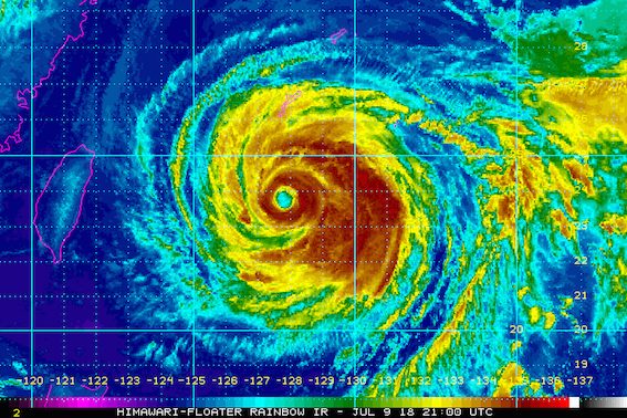
MANILA, Philippines – Typhoon Gardo (Maria) slightly weakened again before dawn on Tuesday, July 10, but it continued to enhance the southwest monsoon or hanging habagat, which is bringing rain.
In a briefing past 5 am on Tuesday, state weather bureau PAGASA said Gardo now has maximum winds of 170 kilometers per hour (km/h) from the previous 185 km/h and gustiness of up to 210 km/h from the previous 225 km/h.
The typhoon is already 760 kilometers east northeast of Basco, Batanes, still moving west northwest at a relatively fast 30 km/h.
Gardo is not expected to make landfall in the Philippines, so tropical cyclone warning signals will not be raised in any area.
But PAGASA warned that the typhoon is enhancing the southwest monsoon or hanging habagat, which is affecting Luzon and the Visayas.
Monsoon rains are being experienced in Metro Manila, Palawan, Oriental Mindoro, Occidental Mindoro, Romblon, Zambales, Pampanga, Bulacan, Cavite, Batangas, and Bataan.
Residents of these areas primarily affected by the southwest monsoon should be on alert for possible flash floods and landslides, especially in low-lying or in mountainous areas. (READ: FAST FACTS: Tropical cyclones, rainfall advisories)
The rest of Luzon and Western Visayas also have scattered rainshowers and thunderstorms due to the southwest monsoon. Flash floods and landslides are possible, too.
Several areas have suspended classes for Tuesday due to the monsoon rains. (READ: #WalangPasok: Class suspensions, Tuesday, July 10)
PAGASA also warned that sea travel remains risky in the northern and eastern seaboards of Northern Luzon.
Based on its latest forecast track, Gardo will leave the Philippine Area of Responsibility (PAR) either Tuesday evening or Wednesday morning, July 11. Its exit could happen as early as Tuesday evening due to its relatively fast speed. (READ: PAGASA: Typhoon Gardo different from Yolanda)
Gardo is the Philippines’ 7th tropical cyclone for 2018. The country usually gets an average of 20 tropical cyclones per year. (READ: LIST: PAGASA’s names for tropical cyclones in 2018)
PAGASA had declared the start of the rainy season last June 8. – Rappler.com
Add a comment
How does this make you feel?
There are no comments yet. Add your comment to start the conversation.