SUMMARY
This is AI generated summarization, which may have errors. For context, always refer to the full article.
What’s the weather like in your area? Report the situation through Rappler’s Agos or tweet us at @rapplerdotcom.
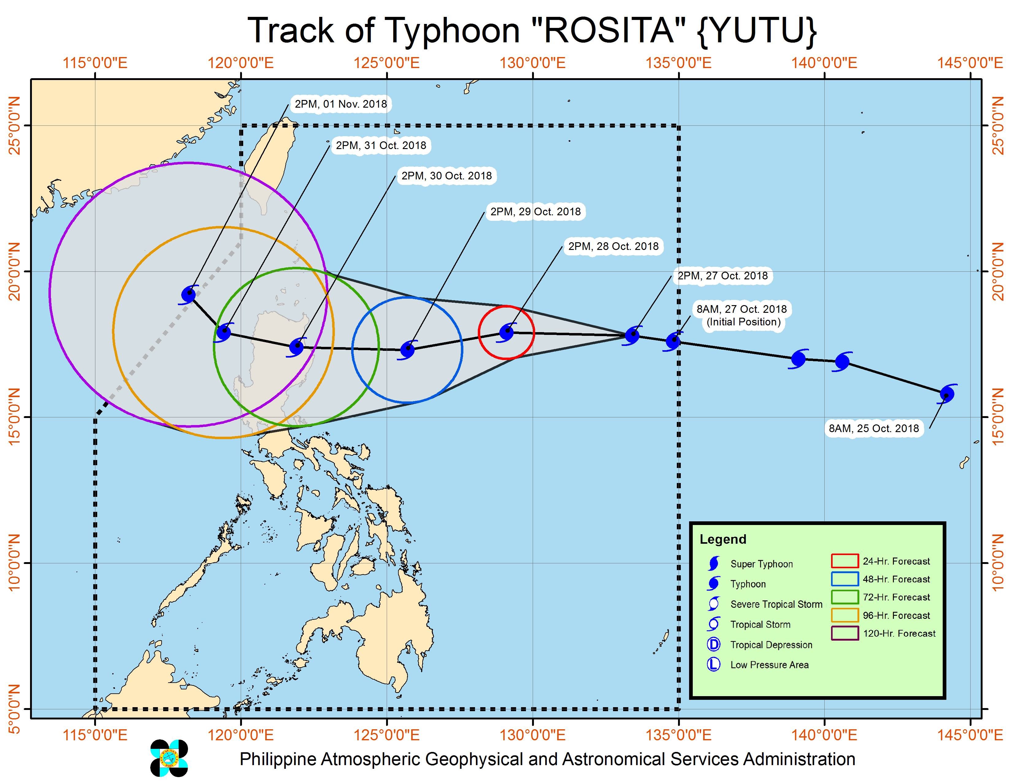
MANILA, Philippines – Typhoon Rosita (Yutu) slightly accelerated on Saturday afternoon, October 27, while maintaining its strength.
In a press briefing past 5 pm on Saturday, the Philippine Atmospheric, Geophysical, and Astronomical Services Administration (PAGASA) said Rosita is already 1,214 kilometers east of Aparri, Cagayan. It is now moving west at a slightly faster 25 kilometers per hour (km/h) from the previous 20 km/h.
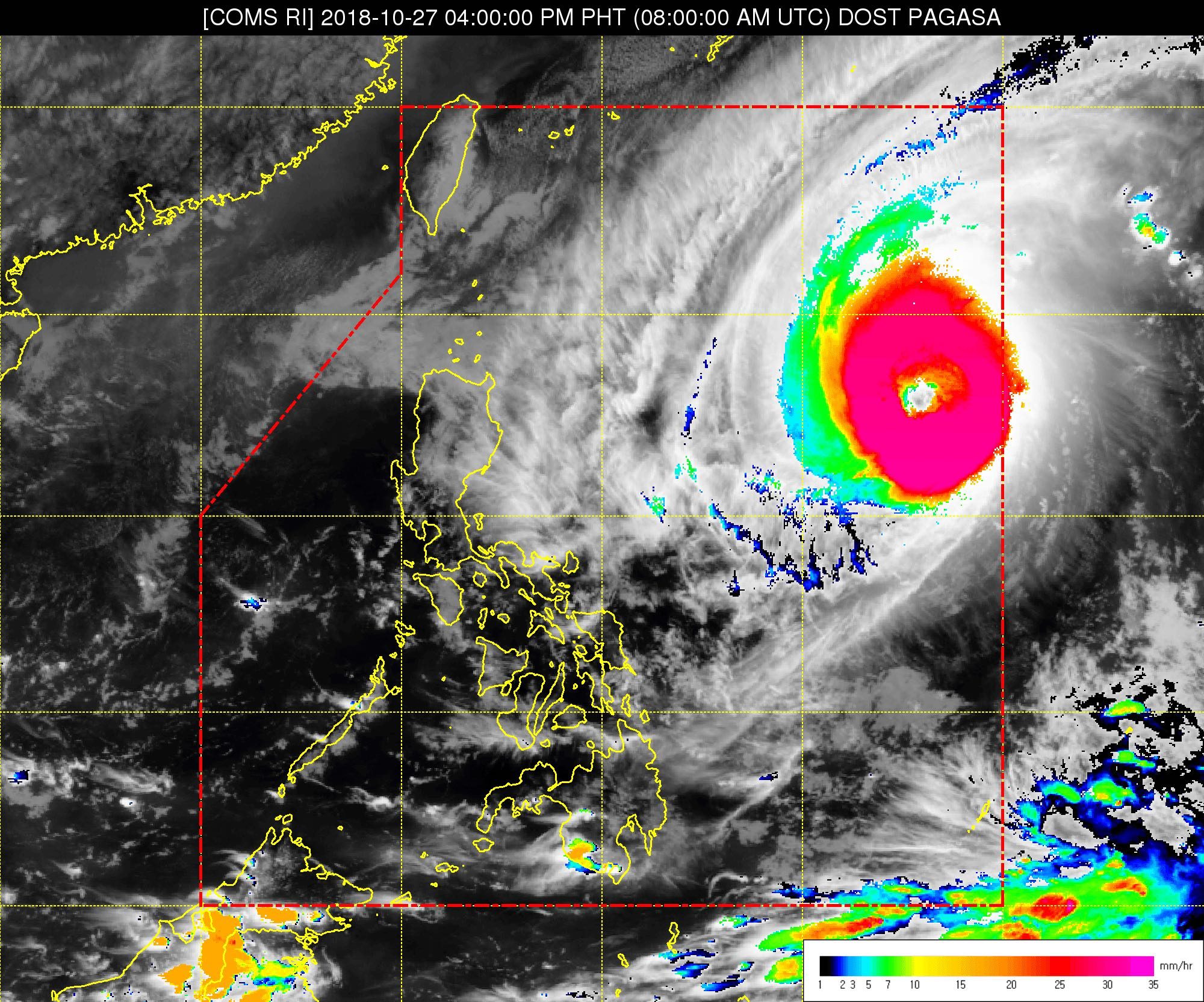
The typhoon continues to have maximum winds of 200 km/h and gustiness of up to 245 km/h. It has a huge diameter of 800 kilometers.
PAGASA said tropical cyclone warning signals may be raised in parts of Northern Luzon and Central Luzon as early as Sunday evening, October 28.
Moderate to heavy rain from Rosita may begin hitting Northern Luzon and Central Luzon starting Monday evening, October 29. Also on Monday evening, Signal No. 1 could be raised in Metro Manila. (READ: #WalangPasok: Class suspensions, Monday, October 29)
Strong to very strong winds are also expected to affect parts of Northern Luzon and Central Luzon beginning Tuesday morning, October 30.
Then, also on Tuesday, Rosita might make landfall in the area of Isabela and Cagayan. (READ: FAST FACTS: Tropical cyclones, rainfall advisories)
PAGASA warned that flash floods and landslides are possible in areas in the typhoon’s path, especially in low-lying communities or in mountainous regions. Residents should be on alert and follow authorities’ instructions.
Rosita’s track is similar to that of Typhoon Ompong (Mangkhut), which made landfall in Cagayan last September 15. Ompong triggered deadly landslides, particularly in the Cordillera Administrative Region (CAR).
If Rosita maintains its speed, it would leave the Philippine Area of Responsibility on Thursday, November 1.
Sea travel is also risky in the northern and eastern seaboards of Luzon, as well as in the seaboard of the Samar provinces, Surigao, Siargao, and Dinagat Islands.
A gale warning was issued at 5 pm on Saturday for Batanes, the Babuyan Group of Islands, Calayan, the northern and eastern coasts of Cagayan, the northern and western coasts of Ilocos Norte, Isabela, Ilocos Sur, La Union, Pangasinan, the western coast of Aurora, Camarines Norte, Camarines Sur, Catanduanes, the eastern coast of Albay, the eastern coast of Sorsogon, the eastern coast of Quezon including Polillo Island, Northern Samar, Eastern Samar, Surigao, Siargao, and Dinagat Islands.
Seas off those areas are rough to very rough, with wave heights reaching 2.6 meters to 4.5 meters.
PAGASA advised fishermen and others with small vessels not to set sail in areas covered by the gale warning. Larger vessels should watch out for big waves.
Rosita is the Philippines’ 18th tropical cyclone for 2018. The country usually gets an average of 20 tropical cyclones per year. (READ: LIST: PAGASA’s names for tropical cyclones in 2018)
Aside from the typhoon, the northeast monsoon will also trigger light rain in CAR, Cagayan Valley, the Ilocos Region, and Central Luzon on Sunday. But PAGASA said there will be “no significant impact.”
The rest of the country will also have localized thunderstorms on Sunday, mostly in the afternoon or evening. Flash floods and landslides are possible if the thunderstorms bring heavy rain.
PAGASA declared the start of the rainy season last June 8. – Rappler.com
Add a comment
How does this make you feel?


There are no comments yet. Add your comment to start the conversation.