SUMMARY
This is AI generated summarization, which may have errors. For context, always refer to the full article.
What’s the weather like in your area? Report the situation through Rappler’s Agos or tweet us at @rapplerdotcom.
MANILA, Philippines – Signal No. 3 was raised in 3 areas late Monday morning, October 29, as Typhoon Rosita (Yutu) is now threatening the southern Isabela-northern Aurora area.
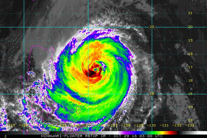
In a press briefing past 11 am on Monday, the Philippine Atmospheric, Geophysical, and Astronomical Services Administration (PAGASA) said Rosita is already 410 kilometers east northeast of Casiguran, Aurora. It is still moving west southwest at 20 kilometers per hour (km/h).
The typhoon weakened due to its interaction with the northeast monsoon or hanging amihan. It now has maximum winds of 150 km/h from the previous 170 km/h, and gustiness of up to 185 km/h from the previous 210 km/h. But PAGASA emphasized that Rosita remains a threat, with a wide diameter of 600 kilometers.
“Pumasok na kasi ‘yung amihan, so sa ngayon ‘yung lamig at drier na hangin na dala ng amihan, nakaapekto sa bagyo…. Kasi ang bagyo natin warm, so kalaban niya ‘yung lamig,” explained PAGASA Assistant Weather Services chief Rene Paciente.
(The northeast monsoon has already begun, so the colder and drier air brought by the northeast monsoon affected the typhoon…. The typhoon has warm air, so it’s in conflict with the air from the northeast monsoon.)
Below are the areas under tropical cyclone warning signals.
Signal No. 3:
- Isabela
- Quirino
- northern part of Aurora
Signal No. 2:
- Cagayan
- Abra
- Kalinga
- Ilocos Sur
- Mountain Province
- Ifugao
- La Union
- Benguet
- Nueva Vizcaya
- Pangasinan
- Tarlac
- Nueva Ecija
- northern part of Quezon including Polillo Island
- southern part of Aurora
Signal No. 1:
- southern part of Quezon
- Ilocos Norte
- Apayao
- Batanes
- Babuyan Group of Islands
- Zambales
- Rizal
- Pampanga
- Bulacan
- Metro Manila
- Laguna
- Batangas
- Bataan
- Cavite
- Camarines Norte
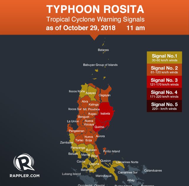
PAGASA warned that stormy weather is expected in areas under Signal Nos. 2 and 3. It is risky to travel by land in those areas.
Moderate to heavy rain and strong to very strong winds are expected to begin hitting Northern Luzon and Central Luzon on Monday evening. (READ: #WalangPasok: Class suspensions, Monday, October 29)
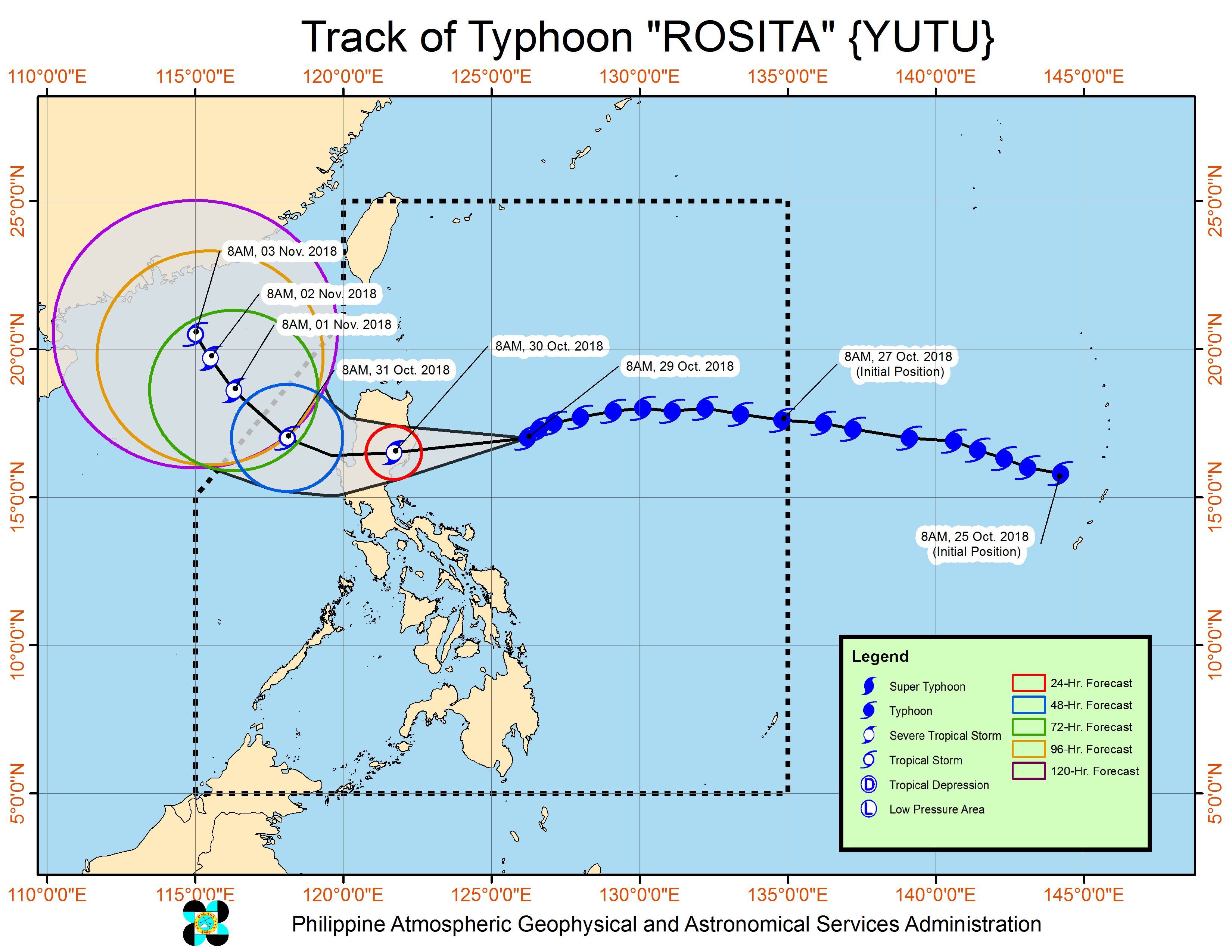
On Tuesday morning, October 30, Rosita could make landfall in the southern Isabela-northern Aurora area. (READ: FAST FACTS: Tropical cyclones, rainfall advisories)
After making landfall, it is expected to cross Aurora, Isabela, Quirino, Ifugao, Nueva Vizcaya, Benguet, and La Union. It might exit landmass on Tuesday afternoon.
PAGASA warned that flash floods and landslides are possible in areas in the typhoon’s path. There might also be storm surges up to 3 meters high in coastal areas of Isabela, Cagayan, Aurora, Ilocos Sur, Ilocos Norte, and La Union. (READ: Cagayan braces for Typhoon Rosita a month after Ompong)
Sea travel is also risky in the seaboards of areas under tropical cyclone warning signals, as well as in the eastern seaboards of Southern Luzon, the Visayas, and Mindanao.
A gale warning was issued at 5 am on Monday for Batanes, the Babuyan Group of Islands, Calayan, Cagayan, Isabela, Ilocos Norte, Ilocos Sur, La Union, Pangasinan, Aurora, Zambales, Bataan, Camarines Norte, Camarines Sur, Catanduanes, the eastern coast of Albay, the eastern coast of Sorsogon, the eastern coast of Quezon including Polillo Island, Northern Samar, Eastern Samar, Surigao, Siargao, and Dinagat Islands.
Seas off those areas are rough to very rough, with wave heights reaching 2.6 meters to 4.5 meters.
PAGASA advised fishermen and others with small vessels not to set sail in areas covered by the gale warning. Larger vessels should watch out for big waves.
Based on Rosita’s latest forecast track, it will leave the Philippine Area of Responsibility on Wednesday evening, October 31.
Rosita is the Philippines’ 18th tropical cyclone for 2018. The country usually gets an average of 20 tropical cyclones per year. (READ: LIST: PAGASA’s names for tropical cyclones in 2018)
PAGASA declared the start of the rainy season last June 8. – Rappler.com
Add a comment
How does this make you feel?
There are no comments yet. Add your comment to start the conversation.